
Öjendorfer Park
Coordinates: 53 ° 33 ′ 28 " N , 10 ° 8 ′ 42" E


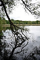
The Öjendorfer Park is a listed public park in the east of Hamburg . The character of the park is determined by the large Öjendorfer Lake , which lies almost in the middle .
location
Öjendorfer Park is located on the eastern edge of the Hamburg district of Billstedt . Its almost rectangular area extends over almost 140 hectares and is framed by the Öjendorf cemetery in the west, the federal motorway 24 in the north, the Barsbütteler Weg in the east and the Driftredder in the south. With the cemetery, the Schleemer Bach valley , the adjoining allotment gardens and other immediately adjacent open spaces, it forms a closed, lavishly designed green zone of almost 400 hectares.
history
The park was created on an originally agricultural area, where a sand pit was operated from 1925 to 1929 . After the Second World War, between 1950 and 1953, around 25 million tons of rubble from the destroyed eastern districts of Hamburg were deposited in the up to 12 m deep pit . In 1954, the remaining parts of the pit were filled with water from the Schleemer Bach. From 1957 to 1966 there was a rubble treatment plant on the site that delivered grit for the construction industry. The remaining material has been used to shape today's park landscape around the lake since 1958 and gradually planted it with greenery. The park only reached its final shape in 1968.
The entire park area is entered in the Hamburg monument list under No. 39042 .
Furnishing
The park is mainly accessed by a circular path around the lake. On the west side of the lake are the shadier and quieter places in the coppice of the Schleemer Bach, the east side of the lake is dominated by open, sunny lawns. The landscape of the park is hilly and shows an alternation of meadows and forest with only a few flowers.
In the park there are two playgrounds , two bathing areas, large lawns, a kiosk , a mini golf course , table tennis tables, garden chess systems and an artificial hill that is used for sledding in winter . From 1971 to 2013 there was a large and popular wooden play fort on the playground, which was demolished for cost reasons when the playground was redesigned.
gallery

playground
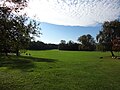
Sunbathing area

The lake with an island
At the Lakeshore

Playground in the east of the park


literature
- Axel Iwohn, Martina Nath-Esser, Claudia Wollkopf: Hamburg Grün - The gardens and parks of the city . L&H Verlag, Hamburg 1998, ISBN 3-928119-39-7 , p. 233-235 .
Web links
- There are two descriptions of the park on www.hamburg.de .
- History of the park on the website of the history workshop Billstedt.
Individual evidence
- ↑ Timeline for Billstedt on the website of the history workshop Billstedt. Retrieved July 3, 2014.
- ↑ List of monuments of the Free and Hanseatic City of Hamburg, as of January 7, 2014 (PDF; 9.3 MB). Free and Hanseatic City of Hamburg, Culture Authority, Monument Protection Office, 2014.
- ↑ Report on the game on the website of the citizenship deputies for Billstedt . Retrieved July 1, 2014.
- ^ Report on the reopening of the playground on the website of the MPs for Billstedt . Retrieved July 1, 2014.

Alsterpark | Old Elbe Park | Baakenpark | Blohms Park | Elbpark Entenwerder | Gustav Mahler Park | Gorch Fock Park | Grasbrookpark | Hammer Park | Horner Moor | Horner Park | Lohsepark | Öjendorfer Park | Planten un Blomen | Rüschpark | Sand Gate Park | Sanitaspark | Thörls Park | Trauns Park | from Dratelnscher Park | Waldpark Steinfurth | Wilhelmsburger Inselpark | Wilhelmsburger Rathauspark