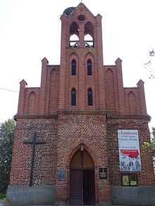
Święty Gaj
| Święty Gaj | ||
|---|---|---|

|
|
|
| Basic data | ||
| State : | Poland | |
| Voivodeship : | Warmia-Masuria | |
| Powiat : | Elbląski | |
| Gmina : | Rychliki | |
| Geographic location : | 53 ° 58 ′ N , 19 ° 24 ′ E | |
| Residents : | 190 (2006) | |
| Telephone code : | (+48) 55 | |
| License plate : | NEB | |
| Economy and Transport | ||
| Street : | Dzierzgoń ↔ Stare Dolno | |
| Rychliki - Kwietniewo → Święty Gaj | ||
| Rail route : | no rail connection | |
| Next international airport : | Danzig | |
Święty Gaj ( German Heiligenwalde ) is a place in the Polish Warmian-Masurian Voivodeship and belongs to the Gmina (rural community) Rychliki (Reichenbach) in the powiat Elbląg (Elbing) .
Geographical location and transport links
Święty Gaj is located on the Młynowka (Mühlenfließ) , 19 kilometers southwest of the former district town Pasłęk (Prussian Holland) and eight kilometers north of the city of Dzierzgoń (Christburg) . Up to the present county seat Elblag (Elbing) is 25 kilometers. The voivodeship border with Pomerania is two kilometers to the west. In the east of the village there is an old Slavic rampart .
There is no longer a train connection. Until 1945 Kwietniewo (Königlich Blumenau , 1931–1945 Königsblumenau) was the next train station on the route from Elbing to Miswalde ( Myślice ), and in 2004 the train route from Malbork (Marienburg) to Małdyty (Maldeuten) with the train station in Dzierzgoń ( Christburg) decommissioned.
history
The place called Heiligenwalde before 1945 was a church village with a domain . The Commander of Christburg ( Dzierzgoń ) and later Grand Master of the Teutonic Order , Luther of Braunschweig , gave the village the festival on April 17, 1324 .
On May 28, 1874 Heiligenwalde came to the newly formed district of Alt Dollstädt ( Stare Dolno ). Until 1945 it belonged to the district of Preussisch Holland in the administrative district of Königsberg in the Prussian province of East Prussia . In 1910 the estate district of Heiligenwalde had 62 inhabitants and the rural community of Heiligenwalde 333.
On September 30, 1928, the rural community and the domain estate merged to form the new rural community of Heiligenwalde. The total number of inhabitants rose to 411 by 1933 and was still 380 in 1939.
As a result of the Second World War , Heiligenwalde came to Poland and received the Polish name "Święty Gaj" (which means something like "holy grove"). Today the place is the seat of a Schulzenamt (Polish: sołectwo) within the rural community Rychliki and belongs to the Powiat Elbląski of the Warmian-Masurian Voivodeship (1975 to 1998 Elbląg Voivodeship ).
church
There was already a church in Heiligenwalde in 1330. Before 1945 the population of Heiligenwald was almost without exception Protestant denomination. Heiligenwalde formed with Königlich Blumenau (1931 to 1945 Königsblumenau , today in Polish: Kwietniewo) - this was the parish seat - the parish of Blumenau-Heiligenwalde. After the Reformation it belonged to the Saalfeld Inspection in East Prussia (Polish: Zalewo) and was then incorporated into the Church of Prussian Holland (Polish: Pasłęk) within the church province of East Prussia of the Church of the Old Prussian Union until 1945 .
Today the population of Święty Gaj is predominantly Catholic . The church, now dedicated to Św. Wojciech is now a branch church of the parish in Kwietniewo, but belongs to the Dzierzgoń (Christburg) deanery in the diocese of Elbing of the Catholic Church in Poland . Evangelical Christians living in Święty Gaj belong to the parish in Pasłęk (Prussian Holland) , which is a subsidiary of the parish in Ostróda (Osterode in East Prussia) . It is located in the Masurian diocese of the Evangelical-Augsburg Church in Poland .
Personality of the place
- Otto von Oehlschläger (1831–1904), lawyer and politician
Individual evidence
- ↑ Location information East Prussia picture archive: Heiligenwalde
- ↑ Heiligenwalde at ostpreussen.net
- ^ Rolf Jehke: District of Alt Dollstädt
- ↑ Uli Schubert: Community directory, Prussian Holland district
- ^ Michael Rademacher: German administrative history from the unification of the empire in 1871 to the reunification in 1990. District of Preussisch Holland. (Online material for the dissertation, Osnabrück 2006).

