
Aggtelek
| Aggtelek | |||||
|
|||||
| Basic data | |||||
|---|---|---|---|---|---|
| State : | Hungary | ||||
| Region : | Northern Hungary | ||||
| County : | Borsod-Abaúj-Zemplén | ||||
| Small area until December 31, 2012 : | Edelény | ||||
| District since 1.1.2013 : | Putnok | ||||
| Coordinates : | 48 ° 28 ' N , 20 ° 30' E | ||||
| Height : | 330 m | ||||
| Area : | 43.81 km² | ||||
| Residents : | 521 (Jan. 1, 2011) | ||||
| Population density : | 12 inhabitants per km² | ||||
| Telephone code : | (+36) 48 | ||||
| Postal code : | 3759 | ||||
| KSH kódja: | 09362 | ||||
| Structure and administration (as of 2020) | |||||
| Community type : | local community | ||||
| Mayor : | Patrik Róczei (independent) | ||||
| Postal address : | Kossuth Lajos út 8 3759 Aggtelek |
||||
| Website : | |||||
| (Source: A Magyar Köztársaság helységnévkönyve 2011. január 1st at Központi statisztikai hivatal ) | |||||


Aggtelek [ ɒkːtɛlɛk ] is a Hungarian community in the county Putnok in Borsod-Abaúj-Zemplén .
Geographical location
Aggtelek is located in northern Hungary , 45 kilometers northwest of the city of Miskolc , one kilometer from the Slovakian border. Nearby there is an entrance to the Baradla Caves, which are among the most beautiful stalactite caves in the country. Neighboring communities within five kilometers are Jósvafő and Trizs . Across the Slovak border is the entrance to the Domica stalactite cave on the territory of the Kečovo municipality , which is connected underground with the Baradla Caves. The nearest town, Szendrő, is about 20 kilometers southeast.
history
The area is said to have been inhabited since prehistoric times. After the Mongols left the area, it was uninhabited for a long time. Aggtelek was first mentioned in 1295 under the name Ogogteluk .
In 1858 the area was devastated by a great fire and during the Second World War the nearby front caused great damage.
Thanks to its surroundings, Aggtelek enjoys a high status in tourism. The Aggtelek Karst and the Baradla Domica stalactite cave are part of the UNESCO World Heritage .
Community partnerships
-
 Monastero di Lanzo , Italy
-
 Hrušov (Rožňava), Slovakia
Attractions
- Baradla Caves, connected to the Domica Cave in Slovakia ( Baradla Domica Cave System )
- Cemetery with memorial steles ( Fejfamúzeum és Kopjafa Emlékpark )
- Bell tower of the Reformed Church ( Harangtorony ), built in 1804
- Local history museum ( Tájház )
- Aggtelek National Park
- Roman Catholic Chapel Nagyboldogasszony
- Reformed church, originally built in the 13th century, expanded and rebuilt in 1785
- Sándor Petőfi House of Culture ( Petőfi Sándor Művelődési Ház )
traffic
Country road No. 5603 runs through Aggtelek. From here, secondary road No. 26104 leads in a north-westerly direction to the Slovakian border. The nearest train station is to the east in Perkupa .
photos

Bell tower and Sándor Petőfi House of Culture

Aggtelek Karst
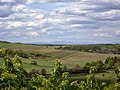
Landscape around Aggtelek


.jpg)
Individual evidence
- ^ Borsod-Abaúj-Zemplén megye polgármestereinek névsora. BOON, October 14, 2019, accessed February 29, 2020 (Hungarian).
Web links
- Aggtelek at Aggteleki Nemzeti Park Igazgatóság ( Hungarian , English )
- Az aggteleki református templom (Hungarian)