
al-Chouf cedar nature reserve
|
Al Chouf Cedar Nature Reserve
|
||
 The Barouk mountain. |
||
| location | Chouf (district) , Lebanon | |
| surface | 550 km² | |
| WDPA ID | 555576134 | |
| Geographical location | 33 ° 42 ' N , 35 ° 42' E | |
|
||
| Setup date | 1996 | |


The Al Chouf Cedar Nature Reserve ( Arabic محمية أرز الشوف الطبيعية, DMG Maḥmīyat Arz aš-Šūf aṭ-ṭabīʿiyya ) is a nature reserve in the Chouf district of Lebanon . It is located on the slopes of Mount Barouk ( Arabic الباروك, DMG al-Bārūk ) and covers an area of 550 km², almost 5.3% of the territory of Lebanon. The park is supported by the German Society for International Cooperation (giz) and the Swiss Agency for Development and Cooperation and was added to the list of biosphere reserves in 2005.
The reserve protects the old groves of Lebanon cedars in Barouk , Maaser el Shouf ( Arabic معاصر الشوف, DMG Maʿāṣir aš-Šūf ), Ain Zhalta ( Arabic عين زحلتا, DMG ʿAin Zaḥaltā ) and Bmohray ( Arabic بمحراي). It is an Important Bird Area (IBA). Ecotourism is to be promoted in the reserve . 32 species of mammals, 200 species of birds and over 500 species of plants were observed. The founder of the reserve is Walid Dschumblat .
Overview
Geological structures
The Barouk Mountains consist of Pliocene deposits which were unfolded by enormous plate tectonic processes. Lebanon consists of two parallel mountain ranges: Anti-Lebanon in the east, and Lebanon proper in the west, closer to the coast of the Levantine Sea . The two mountain ranges are separated by the Bekaa plain , a valley that has been filled with geologically young deposits. The most important type of rock are limestone . The entire Barouk is karstified with frequent sinkholes and caves. A well-known cave is near Niha village . This cave is accessible at approx. 700 m.
The mountains rise to a height of 1980 m above sea level (near Dahr El Baidar ). The mountain slopes become increasingly flatter on the east side of the mountains, while on the west side they steadily increase in steepness. The ridge narrows the further south you go.
Soil condition
The soils belong to the Mediterranean red and brown soils, which develop on hard limestone substrates. The rocks belong to the Jurassic formations of the Bathonian , Callovian , Oxfordian and the Kimmeridgian . The rock proportion is 80–90%. The soils are in equilibrium because they are very permeable, contain many calcareous elements and have a healthy vegetation cover. Therefore they are hardly at risk of erosion .
Hydrology
Due to the rising winds from the sea and incline rain , there is a relatively high amount of precipitation on the west side of the mountains. Snowfall usually only occurs in the higher mountain regions and usually disappears again after a few days, at the latest by the end of the rainy season . Due to the karst structure of the mountains, most of the water quickly penetrates the subsoil, although the soils are relatively shallow and cannot absorb much water. Groundwater feeds the numerous abundant springs on the lower slopes of the mountains. Most of them carry water even in the dry season from April to November and feed the region's major rivers:
- Nahr El Awali or Nahr El Aouali ( Arabic نهر الأولي, DMG Nahr al-ʾAwalī (Nahr El Barouk))
- Nahr ad-Damur (Nahr as-Safa)
The rivers are the main sources of agricultural irrigation and provide water to several villages of the Chouf and some of the villages in the western Bekaa Plain. They also irrigate the Aammiq swamp in Arabic آمق in the Bekaa plain.
climate
The annual rainfall is 1200 mm, the mean annual temperature 11.3 C. The mean daytime temperature is 23.4 C in August, while values of -0.6 C are recorded in January. The absolute temperature scale is between -10.8 C in January and 32.3 C in August. The average relative humidity is 65%, although it should be noted that the eastern slopes are drier. There are 50 to 55 days of snowfall annually according to the Ministry of Labor and Transport .
Flora Fauna
flora
The flora of the area was partially described in the Flora of Lebanon by Paul Mouterde SJ 1966, 1970 and 1983. More recently, the Ministry of the Environment (Protected Areas Project) commissioned Georges Tohmé from the National Council for Scientific Research (NCSR) with investigations in 1999 . In 2002 some results of it were published. 500 different plant species from 61 families have been counted. Of these, 25 species are endangered internationally and nationally, 48 endemic in Lebanon or in Lebanon and Syria or Lebanon and Turkey . 214 species belong to the east-Mediterranean natural area or the Middle East natural area.


24 tree species were counted and the official mandate of the reserve is to protect the last natural occurrence of the Lebanon cedar and to contribute to reforestation. In addition to the Lebanon cedar, the following species form the stock: Cyprus oak (Quercus infectoria) , Brants oak (Quercus brantii) , Kermes oak ( Quercus calliprinos) , Calabrian pine (Pinus brutia) , Aleppo pine (Pinus halepensis) , pine ( Pinus pinea) , Greek juniper (Juniperus excelca) , Syrian juniper (Arceuthos drupacea) .

Kermes oak

Calabrian pine

Aleppo pine
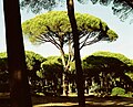
Pine or Italian stone pine

.jpg)


fauna
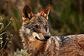
- Mammals: Until the 1970s, there were only a few studies of the species and subspecies of the mammalian fauna.Between 1980 and 1985, Georges Tohmé and Henriette Tohmé compose 33% of the known literature. The only known survey for the area of the reserve was prepared by H. Tohmé in 1999 as part of the NCSR project. In 32 Säugetrierarten were listed: wild boar , wolf , stone marten , mountain gazelle (Gazella gazella) , golden jackal (Canis aureus) , red fox , European badger , Cape hare (Lepus capensis) , Caucasian Squirrel (Sciurus anomalus) , Levantine Mole (Nannospalax ehrenbergi) , Indian White-tailed porcupine (Hystrix indica) , striped hyena (Hyaena hyaena) , wild cat , hyrax (Procavia capensis) . A project has been started to reintroduce the Syrian ibex (Capra nubiana) from Jordan. It is also believed that roe deer , Persian fallow deer (Dama dama mesopotamica) , Anatolian leopard (Panthera pardus tulliana) , wild goat (Capra aegagrus) and Syrian brown bear (Ursus arctos syriacus) could be found well into the 20th century.


wild boar
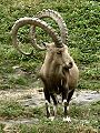
Syrian ibex

Wild goat
wolf

Golden jackal

Persian fallow deer


- Birds: Around 200 species of birds have been observed, 19 of which are rare in Lebanon. However, many of the bird species are migratory birds that only roam the area seasonally. The bird world is made up of species that occur in Europe , Africa and Asia : Chukar grouse (Alectoris chukar) , jay (Garrulus glandarius) , blackbird (Turdus merula) , common raven (Corvus corax) , kestrel (Falco tinnunculus) , lark (Eremophila) alpestris) , Gartenrotschwanz (Phoenicurus phoenicurus) , Buchfink , (Fringilla coelebs) , Turteltaube (Streptopelia turtur) , stone Sperling (Petronia petronia) , Stieglitz (Carduelis carduelis) .
Two species of birds were introduced for hunting purposes: the stone chicken (Alectoris graeca) and the pheasant (Phasianus colchicus) . The most important large birds of prey are: griffon vulture (Gyps fulvus) and golden eagle (Aquila chrysaetos) .

Chukar chicken

pheasant

The subspecies of the jay Garrulus glandarius atricapillus in Israel

Blackbird

Kestrel

Golden eagle

Goldfinch

Vulture portrait

.jpg)


- Reptiles and Amphibians: The reserve offers habitats for a wide variety of reptiles. 26 species were counted, two of which are endemic to Lebanon . 4 amphibian species were documented. Among other things live there: Palestine viper (Vipera Palaestinae) , thighed tortoise (Testudo graeca) , Chameleon , locust lizard (Ablepharus kitaibelii) , common toad , green toad (Bufo viridis) , Near Eastern Fire Salamander (Salamandra infraimmaculata) , Middle East Tree Frog (Hyla savignyi) .

Palestinian viper

Chameleon

Tortoise

Locust lizard

Common toad

European green toad

Asian fire salamander

Tree frog


.jpg)
.jpg)


Attractions
Cedar trees
The cedar forests of Lebanon have history as they are among the oldest documented forests in the world. The cedars were already described in the time of the Sumerians in the third millennium BC and in the Gilgamesh epic the cedars play a major role.
- Historical monuments

The confused system of different cultures, religions and world political events has determined the cultural heritage of the Chouf. Culturally, the area is at least as rich as it is in terms of its natural resources.
- Qalaat Niha : The cave fortress of Tyron Niha tells a story of the end of the reign of Fachr ad-Dīn II. The fortress is probably the only one that was used by the Arabs, the Crusaders and the princes of Mount Lebanon .
- El Nabi Ayoub : Above Niha, a reliquary was built in honor of the prophet Job .
- Qab Elias Castle : The mighty Druze fortress used to be a sentry who watched the road between Beirut and Damascus . From there, the emirs of the Shihab family led their troops when they emerged as rulers of southern Bekaa and Wadi al-Taym .
- Mazar El Sit Cha'wane ( Arabic مزار: El Sit Cha'wane ) is a famous lady of Druze history / legend. Like Job, she was revered as a model of virtue and piety. She also has her own reliquary.
literature
- Georges Tohmé, Henriette Tohmé: Nouveaux signalements de plantes du Liban. In: Journal Scientifique Libanais. Vol. 16, No. 2, 2015, ZDB -ID 2836842-3 , pp. 139-141 .
Individual evidence
- ↑ Georges Tohme, Henriette Thomé: Mille et une fleurs du Liban. = A Thousand and one Flowers of Lebanon (= Publications de l'Université Libanaise. Section des Sciences Naturelles. 22, ZDB -ID 2722842-3 ). Université Libanaise, Beirut 2002, ISBN 9953-0-0053-0 .
Web links
- Shouf Biosphere Reserve - official homepage.
- Homepage of the Lebanese government.