
Alburquerque (Bohol)
| Municipality of Alburquerque | |||
| Location of Alburquerque (Bohol) in the province of Bohol | |||
|---|---|---|---|

|
|||
| Basic data | |||
| Region : | Central Visayas | ||
| Province : | Bohol | ||
| Barangays : | 11 | ||
| District: | 1. District of Bohol | ||
| PSGC : | 071201000 | ||
| Income class : | 6th income bracket | ||
| Households : | 1670 May 1, 2000 census
|
||
| Population : | 10,540 August 1, 2015 census
|
||
| Population density : | 367.9 inhabitants per km² | ||
| Area : | 28.65 km² | ||
| Coordinates : | 9 ° 36 ' N , 123 ° 57' E | ||
| Postal code : | 6302 | ||
| Mayor : | Dr. Cirilo P. Jalad | ||
| Website: | Alburquerque | ||
| Geographical location in the Philippines | |||
|
|||

Alburquerque is a Filipino municipality in the southwest of Bohol Province with 10,540 inhabitants (August 1, 2015 census).
The place initially had the name Segunto and belonged to the municipality of Baclayon . On June 9, 1868, after a decree of the Governor General Jose de la Gandara, an independent municipality was founded and the name was changed to Alburquerque. The community was named after a city of the same name in what is now New Mexico , which in turn was named after Fernández de la Cueva, the then viceroy of New Spain , eighth Duke of Alburquerque. The Boholanos only briefly call the city Albur .
Barangays
Alburquerque is politically divided into 11 barangays .
|

photos

Church in Alburquerque
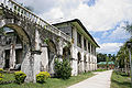
Santa Monica Monastery
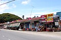
Sari-sari shops along the street


