
Loboc
| Municipality of Loboc | |||
| Location of Loboc in Bohol Province | |||
|---|---|---|---|

|
|||
| Basic data | |||
| Region : | Central Visayas | ||
| Province : | Bohol | ||
| Barangays : | 28 | ||
| District: | 3. Bohol District | ||
| PSGC : | 071229000 | ||
| Income class : | 5th income bracket | ||
| Households : | 2738 May 1, 2000 census
|
||
| Population : | 15,993 August 1, 2015 census
|
||
| Population density : | 187.2 inhabitants per km² | ||
| Area : | 85.41 km² | ||
| Coordinates : | 9 ° 38 ' N , 124 ° 2' E | ||
| Postal code : | 6316 | ||
| Mayor : | Leon A. Calipusan | ||
| Website: | Loboc | ||
| Geographical location in the Philippines | |||
|
|||

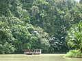
The municipality of Loboc is located in the interior of the Philippine island of Bohol , 24 km from the provincial capital Tagbilaran . Loboc is located in a valley that is crossed by the Loboc River. Loboc has a population of 15,993 (August 1, 2015 census).
The old church from the Spanish era with a separate church tower is well worth seeing. Loboc is also known for its children's choir.
The place is a stopover for tourists en route to the Chocolate Hills . Raft trips on the Loboc River to the falls are available. The Church of San Pedro Apostol is in Loboc and has been on the Philippines' list of proposals for inclusion in the UNESCO World Heritage List since 2006. However, it was largely destroyed in an earthquake on October 15, 2013.
Barangays
Loboc is politically divided into 28 barangays .
|
|
|

Loboc

Loboc Church
Loboc River


Individual evidence
- ↑ Heartbreaking: 10 iconic churches in Bohol, Cebu damaged. rappler.com, October 15, 2013, accessed October 15, 2013 .