Alfredo Chaves
| Município de Alfredo Chaves Terra da Banana e do Leite
Alfredo Chaves
|
|||
|---|---|---|---|
|
Station Matilde
|
|||
|
|
|||
| Coordinates | 20 ° 38 ′ S , 40 ° 45 ′ W | ||
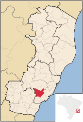
 Location of the municipality in the state of Espírito Santo Location of the municipality in the state of Espírito Santo
|
|||
| Symbols | |||
|
|||
| founding | January 24, 1891 | ||
| Basic data | |||
| Country | Brazil | ||
| State | Espírito Santo | ||
| ISO 3166-2 | BR-ES | ||
| Região intermediária | Vitória (since 2017) | ||
| Região imediata | Vitória (since 2017) | ||
| structure | 7 districts | ||
| Waters | Rio Benevente | ||
| climate | tropical mountain climate, Cfa, Aw | ||
| surface | 615.8 km² | ||
| Residents | 13,955 (2010) | ||
| density | 22.7 Ew. / km² | ||
| estimate | 14,566 (July 1, 2018) | ||
| Parish code | IBGE : 3200300 | ||
| Telephone code | (+55) 27 | ||
| Time zone | UTC −3 | ||
| Website | www.alfredochaves.es.gov.br (Brazilian Portuguese) | ||
| politics | |||
| City Prefect | Fernando Videira Lafayette (2017-2020) | ||
| Political party | PSB | ||
| economy | |||
| GDP | 295,731 thousand R $ 19,751 R $ per capita (2015) |
||
| HDI | 0.710 (2010) | ||
Alfredo Chaves , officially Portuguese Município de Alfredo Chaves , is a small Brazilian town in the state of Espírito Santo , about 60 km southwest of the state capital Vitória inland. Alfredo Chaves had 13,955 inhabitants at the 2010 census and an area of 615.791 km². As of July 1, 2018, the population was already estimated at 14,566 inhabitants, who are called Alfredenses (Portuguese alfredenses ).
geography
Alfredo Chaves is located in the southwest of the state. The community is criss-crossed by hills. The highest peak is Trancenco Peak at 1,050 m above sea level. The city center of Alfredo Chaves is only 10 m above sea level.
history
The place was founded as a colony by Italian immigrants and was originally called Alto Benevente . As early as 1817 there were fatal incidents with the Botokuden , the local ethnic group. Another attack in 1878, triggered by the expansion of the settlement area, caused Emperor Dom Pedro II to send his colonization minister, engineer Alfredo Rodrigues Fernandes Chaves , to the area for pacification and protection. In his honor, the place was initially named Vila de Alfredo Chaves , then Município de Alfredo Chaves when it received city rights .
economy
Livestock is the most important branch of the economy, especially dairy cows and chickens are raised. Coffee and banana plantations also play an important role.
sons and daughters of the town
- Haydée Nicolussi (1905–1970), writer, translator and political activist
literature
- Hesio Pessali: Alfredo Chaves. Uma visão histórica e política . Ed .: Câmara Municipal de Alfredo Chaves. 2nd Edition. Alfredo Chaves 2015 (Brazilian Portuguese, gov.br [PDF]).
Web links
- City Prefecture website , Prefeitura Municipal (Brazilian Portuguese)
- City Council website , Câmara Municipal (Brazilian Portuguese)
- Map by Alfredo Chaves
- Tourism site Alfredo Chaves (Brazilian Portuguese)
Individual evidence
- ↑ Alfredo Chaves climate: average temperature, weather by month, Alfredo Chaves weather averages. In: climate-data.org. de.climate-data.org, accessed on November 6, 2018 .
- ↑ a b IBGE : Alfredo Chaves - Panorama . Retrieved November 6, 2018 (Brazilian Portuguese).
- ↑ a b IBGE : Estimativas da população residente no Brasil e unidades da federação com data de referência em 1 ° de julho de 2018. (PDF; 2.6 MB) In: ibge.gov.br. 2018, accessed November 6, 2018 (Brazilian Portuguese).
- ↑ História , a brief history of the city on the website of the city prefecture. Retrieved May 11, 2014.
- ↑ Hesio Pessali: Alfredo Chaves. Uma visão histórica e política. 2nd Edition. Câmara Municipal de Alfredo Chaves, Alfredo Chaves 2015, p. 29 f.


