Jeetzel
|
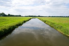
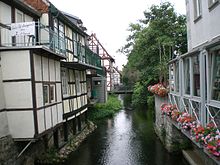
Jeetzel In Saxony-Anhalt: Jeetze |
||
|
Jeetzel on the lower reaches between Seerau and Hitzacker during floods |
||
| Data | ||
| Water code | EN : 5934 | |
| location | Germany, Saxony-Anhalt and Lower Saxony | |
| River system | Elbe | |
| Drain over | Elbe → North Sea | |
| source | At Altferchau (town of Klötze ) 52 ° 35 ′ 47 ″ N , 11 ° 1 ′ 40 ″ E |
|
| Source height | approx. 61 m above sea level NN | |
| muzzle | In Hitzacker in the same at 522.92 km coordinates: 53 ° 9 '26 " N , 11 ° 2' 38" O 53 ° 9 '26 " N , 11 ° 2' 38" O |
|
| Mouth height | 10 m above sea level NN | |
| Height difference | approx. 51 m | |
| Bottom slope | approx. 0.7 ‰ | |
| length | 73 km | |
| Catchment area | 1928 km² | |
| Discharge at the Lüchow A Eo gauge : 1300 km² Location: 26 km above the mouth |
NNQ (July 2, 1992) MNQ 1967–2014 MQ 1967–2014 Mq 1967–2014 MHQ 1967–2014 HHQ (March 13, 1981) |
321 l / s 1.29 m³ / s 6.13 m³ / s 4.7 l / (s km²) 30.7 m³ / s 62.9 m³ / s |
| Discharge at the mouth of the A Eo : 1928 km² |
MQ Mq |
9 m³ / s 4.7 l / (s km²) |
| Left tributaries | Tangelnscher Bach, Hartau, Salzwedeler Dumme, Graue Laake, Wustrower Dumme, Prisserscher Bach, Harlinger Bach | |
| Right tributaries | Landgraben, Purnitz, Lüchower Landgraben, Dannenberger Landgraben, Lucie Canal | |
| Small towns | Salzwedel , Wustrow , Lüchow , Dannenberg , Hitzacker | |
| Communities | Beetzendorf | |
The Jeetzel is an approximately 73 km long left southern tributary of the Elbe in the north German lowlands in the federal states of Saxony-Anhalt and Lower Saxony . In Saxony-Anhalt the river is called Jeetze . From the 13th to the 19th century, the river was an important trade route.
geography
course
The flowing water has its source as Jeetze in the southwest Altmark in the north of Saxony-Anhalt. Its source is located near the village of Altferchau in the terminal moraine complex of the southern ridge , north of the Drömling . From there it runs north, takes in the tributaries Hartau and Tangelnscher Bach , crosses the ground moraines of the " Altmarkplatten ", passes Salzwedel and shortly thereafter arrives in Lower Saxony. Here, in Wendland , where the Jeetzel river is called, it now flows further north through formerly marshland lowlands, parallel to the Drawehn ridge, through the cities of Wustrow , Lüchow and Dannenberg , to flow into the Elbe at Hitzacker (see also: natural spaces Main unit group Wendland and Altmark ).
The 820 m estuary is one of the so-called other federal inland waterways for which the Lauenburg Waterways and Shipping Office is responsible.
Tributaries
For river system in the Jeetzel are even 79 more named river next to the Jeetzel. The river has a catchment area of 1928 square kilometers. The 26 direct tributaries of the Jeetzel include:
- Hartau
- Purnitz
- Salzwedeler stupid
- Lüchower Landgraben
- Wustrower stupid
- Lübelner Mühlenbach
- Luciekanal
Surname
The river name is possibly of Slavic origin and in this case would be derived from the old Slavic jasenu , which means something like Eschenbach (compare Czech "jasan" or Polish jesion = German ash ). This could be due to the fact that the river banks were lined with ash and alder-ash forests. An alternative explanation is the derivation from the Germanic geza (ferment, wallen, go up).
Flow regulations
When the Elbe is in high water, the Jeetzel floods in a characteristic way, which now flows “backwards”. In earlier centuries there were therefore regular extensive floods in the lowlands of the central Wendland (the main moorland between Lüchow and Dannenberg is called "the Lucie"). Since the 1950s, extensive hydraulic engineering measures have been implemented in this area, which already belongs to the Elbe glacial valley : A new canal (“Neue Jeetzel”, “Jeetzel Canal”) was created. This larger, controllable receiving river enabled extensive drainage of the moored lowland and the periodic flooding was contained. The now "Alte Jeetzel" continues to meander - but only with a fraction of the previous discharge - in parallel to it, before finally being fed to the Jeetzel Canal behind Dannenberg via a pumping station.
The water management interventions in favor of intensive agriculture and settlement protection have largely ecologically degraded the pristine natural landscape. Much of the fen area was drained and cut off from seasonal floods. This is why this retention area for flood discharge peaks is now also missing . If the Jeetzel backs up today when the Elbe floods, the water level between the now too narrow dike corset rises very quickly. Since the sand dams are technically outdated, there is a latent risk of dike breaches and sudden flooding of the hinterland between Lüchow and Dannenberg.
In the estuary near the Elbe, the backwater of the Jeetzel, as before the regulation, intensifies the flood effects for the town of Hitzacker, among others. The old town is then not only enclosed by the previously unsealed side of the Elbe, but also by swelling arms of the Jeetzel and literally transformed into an island (“city island”). The highest floods to date were measured in April 2006, August 2002 and 1895 and put the old town under water.
After the floods of 2006, a barrier structure was built that enables the Jeetzel and Hitzacker to be completely separated from the Elbe floods. This includes a wall that can be raised with metal plates if necessary, and a gate at the mouth of the Jeetzel. A pumping station with a pumping capacity of 60 m³ / s, which pumps incoming water from the Jeetzel into the Elbe, was put into operation in 2008. In addition, dyke defense routes were concreted from Jameln downstream on both sides of the Jeetzel (from Lüggau only on the right bank) in order to give the Jeetzeldeichverband unhindered access to the dyke.
natural reserve
In 2004, parts of the catchment area of the middle and lower Jeetzel were registered by the state of Lower Saxony under the name "Water system of the Jeetzel with spring forests" as an FFH area within the framework of the European Natura 2000 concept . In addition to the main course, sections of the backwaters (various “mill streams” flowing from the Drawehn) are also included. The lower course near the mouth belongs to the FFH area "Elbe Valley Lowlands between Schnackenburg and Lauenburg" and to the " Lower Saxon Elbe Valley Biosphere Reserve ".
The Alte Jeetzel is used as a canoeing area for tourists.
literature
- M. Eckoldt (ed.): Rivers and canals. The history of the German waterways . DSV-Verlag 1998
Web links
- Jeetz boat trip to and from Salzwedel: towels and beer to Gotland
- Exhibition in the Museum Zollhaus Hitzacker: The Jeetzel: a river tells stories
Individual evidence
- ↑ a b Lengths (in km) of the main shipping lanes (main routes and certain secondary routes) of the federal inland waterways ( Memento of the original from January 21, 2016 in the Internet Archive ) Info: The archive link was automatically inserted and not yet checked. Please check the original and archive link according to the instructions and then remove this notice. , Federal Waterways and Shipping Administration
- ^ German Hydrological Yearbook Elbe Region, Part III 2014. (PDF) ISSN 0949-3654. Free and Hanseatic City of Hamburg, Hamburg Port Authority, p. 137 , accessed on October 4, 2017 (German, at: dgj.de).
- ↑ Extrapolation of the MQ value of the Lüchow gauge (the characteristics of the catchment area regulating the drainage area differ only insignificantly above and below the gauge.)
- ↑ Directory F of the Chronicle ( Memento of the original from July 22, 2016 in the Internet Archive ) Info: The archive link was automatically inserted and not yet checked. Please check the original and archive link according to the instructions and then remove this notice. , Federal Waterways and Shipping Administration
- ↑ Michael Bergemann: Complete list of flowing waters in the Elbe catchment area . Authority for the Environment and Energy, Hamburg July 1, 2015 ( fgg-elbe.de [PDF; 802 kB ; accessed on November 29, 2015]).
- ^ Entry "Schöpfwerk" in Wendlandlexikon Volume 2 LZ, ISBN 978-3-926322-45-6


