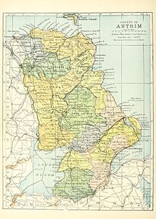
County Antrim
| map | |
|---|---|

|
|
| Basic data | |
| Country: |
|
| Administrative headquarters: | Antrim |
| Province: | Ulster |
| Irish name: | Aontroim |
| Surface: | 2845 km² |
| Residents: | 566,000 (estimate) |

Antrim ( Irish : Aontroim ) is one of six historic counties ( counties ) of Northern Ireland .
geography
The county lies between Lough Neagh , the River Bann and the coast of the Irish Sea , the North Channel. Most of the county is made up of the Antrim Mountains in the northwest. The eastern half of Lough Neagh, a large lake, is also part of the county.
history
The north of the county has belonged to the Christian kingdom of Dalriada since the 5th century . The Irish part was separated from the Scottish part by the Normans in the early 9th century and formed the Kingdom of Ulidia (or Ulaidh) with what is now County Down . After the conquest by the Normans in the 12th century, this continued as the county of Ulster . The English sovereignty weakened over time, until it was renewed in the 17th century by Oliver Cromwell . The county was formed and the land was distributed to English landowners.
economy
The economy is concentrated in the Belfast catchment area , which extends up to Antrim . The rest of the country is heavily agricultural with sheep and cattle breeding. The town of Bushmills is economically important, with Old Bushmills, one of the most famous and oldest whiskey distilleries in the country. Numerous types of whiskey, some of them high-quality, are produced there.
Cities
Attractions
- Altagore Cashel
- Ardclinis Church
- Ballyvennaght Portal and Court Tombs
- Ballywee Raths and Basement
- Ballyutoag ,
- Carrick-a-Rede : suspension bridge
- Carn-na-truagh cairn grave
- Court Tomb by Antynanum
- Culfeightrin Stones two menhirs
- Derrykeighan stone , decorated stone (Celtic)
- Craigs Dolmen
- Dooey's Cairn Court tomb
- Menhirs of Duncarbit
- Dunluce Castle
- Giant's Causeway (UNESCO World Heritage)
- Knockdhu basement , basement
- Circles by Lissanduff , stone circles
- Ossian's Grave Court tomb
- Crannóg in Lough-Na-Crannagh
- Armoy round tower
- Broughanlea Hochkreuz
- Bunamargy Friary
- Castle Carra
- Cloghastucan, rock needle
- Doonan Fort Moth
- Drumnakill Church
- Dunseverick Castle
- Glenarm Friary
- Glynn Old Church
- Layd Church and Holy Well
- Linford Barrows and Cashel
- Lough na Crannagh Crannóg
- Olderfleet Castle
- Red Bay Castle: Promontory Fort
- Templastragh Church
- White Park Bay Mound
See also
Web links
Coordinates: 54 ° 50 ′ N , 6 ° 10 ′ W


