
Asel (Vöhl)
|
Asel
Vöhl municipality
Coordinates: 51 ° 11 ′ 44 " N , 8 ° 56 ′ 42" E
|
|
|---|---|
| Height : | 297 m above sea level NHN |
| Area : | 11.24 km² |
| Residents : | 238 (2014) |
| Population density : | 21 inhabitants / km² |
| Incorporation : | 1st February 1971 |
| Postal code : | 34516 |
| Area code : | 05635 |
 Location of Asel in Vöhl
|
|
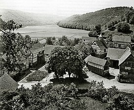
 Gutshof in Asel-Süd (October 2010)
|
|
Asel and Asel-Süd are part of the municipality of Vöhl in the Waldeck-Frankenberg district in northern Hesse .
geography
Asel is located south of Vöhl in the northern part of the Kellerwald-Edersee nature park on the Edersee . The village with its two districts, Asel and Asel-Süd, is the only part of the municipality of Vöhl on both sides of the reservoir : Asel is on a mountain ("Auf dem Weinberg") north of the Edersee, Asel-Süd on the south bank of the lake or on the north slope of the Kellerwald and the Kellerwald-Edersee National Park . The Eder or Edersee tributary Aselbach flows through the valley east of Asel .
history
In Asel the approximately 60 m long, four-arched "Aseler Bridge" led over the Eder. It was built from 1887 to 1890 and was the long-awaited connection between Asel, which lay down in the river valley on the north bank of the Eder, and the estate on the southern slopes of the Edertal. While the bridge was being built, it was not foreseeable that the river would be dammed into a large lake. When the Edertalsperre was built from 1908 to 1914 only about 7.5 km (as the crow flies ) to the east, the days of the bridge as a usable river crossing were numbered. The residents of the village of Asel in the Edertal, which has been called "Alt-Asel" since the reservoir was flooded, looked for a new place to stay. On the ridge "Auf dem Weinberg", north of the newly emerging Edersee, they built the Asel district mostly on their own, and Asel-Süd, which had previously only consisted of an estate, was built on the opposite bank of the future reservoir. Only small remains of the old location are visible today. At the time of the resettlement in 1913, Asel was not a rich community. Everything that could be dismantled was dismantled and taken away or sold. The remains were blown up by pioneers. Only a few foundations can still be found. In the last few years, the Aselers have made showcases and installations on a private initiative to make the old place tangible.
When the reservoir was flooded, the Aseler Bridge disappeared into the water (highest point at the apex: 235.1 m above sea level ), but it becomes visible again from a water level of 235.10 m. Even after more than 100 years in the water, it is still completely preserved and in good condition, with the exception of its two handrails, which were torn down for safety reasons, and can be walked on and driven with bicycles from approx. 228 m if the water level continues to fall. The Eder then flows back in its old bed and the Aselbach meanders through the valley to the Eder as it did in the past. The dry bottom of the lake turns green within a few days and the former paths and field borders are then clearly visible. The bridge was restored in 1982 and 1989 and is a listed building.
(Alt) -Asel around 1900/1905, before the construction of the Edersee.

The "Aseler Bridge" in the Edersee, which is normally flooded today (July 2017)
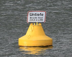
Warning buoy on the sunk in the lake bridge over the river Eder


The small church of (Alt-) Asel, which would have perished in the reservoir, was bought by the community of Lehnhausen and rebuilt there as a school in 1915.
Much of what is now Asel-Süd (with 14 inhabitants) is used by a permanent campsite and a weekend house area. In addition to the old manor (with cattle and agriculture), other permanent buildings include a restaurant including a food market (open seasonally) and a forester's house.
Resettlements
In addition to Asel, the villages of Berich and Bringhausen originally located in the Eder valley and three individual farms were relocated. The village of Neu-Berich is 22 km (as the crow flies) further north; Bringhausen was rebuilt on the higher south bank of the Edersee.
Territorial reform
On February 1, 1971, the place was incorporated into the newly formed municipality of Vöhl as part of the regional reform in Hesse .
Culture and sights

Sights in and near Asel include (alphabetically sorted): * "Alt-Asel" or "Dorfstelle Asel" in the Edersee or on the Eder (to be seen when the water is low)
- "Aseler Bridge" in the Edersee or on the Eder (to be seen at low water)
- Monument "Dorfstelle Asel" on the northern edge of the Edersee or Edertal
- Edersee - reservoir of the Eder
- Bat educational trail
- Kellerwald - low mountain range south of the Edersee
- Kellerwald-Edersee National Park - National Park south of the Edersee
- Kellerwald-Edersee Nature Park - Nature Park with Edersee and Kellerwald
- Waldeck Castle - Castle near Waldeck north above the Edersee
traffic
In terms of traffic, Asel-Süd is at the end of a dead end , just like Bringhausen to the east (part of the municipality of Edertal ) . It can only be reached from the western end of the Edersee via the Vöhler districts of Herzhausen and Harbshausen on the county road "K 59" or via hiking trails. Likewise, Asel itself can only be reached via the district road 31 from Vöhl; From the Hohe Fahrt youth hostel, the route to Herzhausen is only open to hikers and cyclists. When the water level is high, a small motorized passenger ferry, the "Asel ferry", runs between Asel-Süd and Asel; it is also suitable for transporting bicycles. The jetty on the Asel side (north bank) is sometimes also used by excursion boats of the "Edersee Personnel Shipping". Asel and, in combination with the ferry, Asel-Süd can be reached on the waterway by tourist ship in the seasonal regular service from Waldeck , the Scheid peninsula or Bringhausen.
Web links
- Asel district on the website of the municipality of Vöhl-
- Asel (Neu-Asel), Waldeck-Frankenberg district. Historical local dictionary for Hessen. In: Landesgeschichtliches Informationssystem Hessen (LAGIS).
- Photos of the sunken bridge at Asel ( Memento from March 13, 2005 in the Internet Archive )
- When the lost villages appear (Three Videos from Edersee-Atlantis), HNA, September 5, 2016 , accessed on November 9, 2016
Individual evidence
- ↑ a b The place on the website of the municipality of Vöhl , accessed in April 2016.
- ^ History of the districts of Wohra
- ↑ Hercules TV magazine ; hr television, June 5, 2011
- ^ Municipal reform: mergers and integration of municipalities from January 20, 1971 . In: The Hessian Minister of the Interior (ed.): State Gazette for the State of Hesse. 1971 No. 6 , p. 248 , Item 328, Para. 31 ( Online at the information system of the Hessian State Parliament [PDF; 6.2 MB ]).
- ^ Federal Statistical Office (ed.): Historical municipality directory for the Federal Republic of Germany. Name, border and key number changes in municipalities, counties and administrative districts from May 27, 1970 to December 31, 1982 . W. Kohlhammer GmbH, Stuttgart and Mainz 1983, ISBN 3-17-003263-1 , p. 389 .

Asel | Basdorf | Buchenberg | Village knight | Ederbringhausen | Harbshausen | Herzhausen | Kirchlotheim | Marienhagen | Niederorke | Obernburg | Oberorke | Schmittlotheim | Thalitter | Vöhl