
Aspern
| Aspern | |
|---|---|
| coat of arms | map |
 |

|
Aspern was an independent municipality until it was incorporated into Vienna in 1904/05 and is now a district in the 22nd district of Vienna , the Donaustadt , as well as one of the 89 Viennese cadastral communities . A small part of the cadastral community of Aspern is located in the 2nd district, Leopoldstadt .
geography


Aspern lies between the Lobau , Stadlau , Breitenlee , Essling and Hirschstetten . The cadastral municipality covers an area of 2012.87 hectares , of which 24 hectares are in the Leopoldstadt municipal district.
history
The former village went down in history with the battle of Aspern on May 21 and 22, 1809. In this battle, the Austrian army under Archduke Charles defeated Napoleon I for the first time since he came to power. A monumental sculpture in front of St. Martin's Church in Aspern , the Lion of Aspern , has been a reminder of this battle since 1858.
The Aspern area is one of the oldest settlement areas in Vienna. The first written mention of the place took place in 1258 as Asparn . During the Turkish sieges of 1529 and 1683, the village was badly damaged or destroyed. Today's Aspern cemetery was laid out in 1892. In 1904/05, the strongly agricultural Aspern was incorporated as part of the new 21st district of Vienna, which was given the name Floridsdorf . On October 15, 1938, the NSDAP regime transferred the district to the 22nd district called Groß-Enzersdorf, which was newly formed when Greater Vienna was created . When Greater Vienna, as decided in 1946, was greatly reduced in size in 1954, Aspern remained near Vienna and since then has formed the 22nd district called Donaustadt with seven other former municipalities.
The Aspern airfield was opened in 1912 . Up until the Second World War, this was the center of Austrian civil and military aviation. After the Second World War, the airfield was used by the Soviet occupation forces; the parts of Vienna on the left bank of the Danube that had already belonged to Vienna before 1938 belonged to the Soviet sector of Vienna until 1955 , parts added in 1938 to the Soviet occupation zone of Lower Austria. In 1977 the airfield was closed.
In 1979, a contract was signed between Federal Chancellor Bruno Kreisky and GM Austria General Director Helmuth Schimpf regarding the construction of an engine plant in the southern area of the airfield. In 1983, after an investment of 9.8 billion Schillings (roughly estimated around 700 million euros), the plant went into full operation with around 2,200 employees. Up until the 2000s, the plant was expanded several times and is currently (2018) called Opel Vienna .
From 2001 to 2017 the rescue helicopter Christophorus 9 of the ÖAMTC was stationed in its own helicopter station on the former Aspern airfield.
Public transport
Aspern was connected to public transport in the Vienna agglomeration on June 7, 1886. On this day the steam tramway company opened vorm. Krauss & Comp. two lines: one from the Stefanie bridge on the Danube Canal in the 2nd district via Floridsdorf to Stammersdorf , the second, branching off in Floridsdorf, via Kagran and Aspern to Groß-Enzersdorf. After 1901 it was operated from the Augarten Bridge . The travel time from the Danube Canal to Aspern was one hour and five to ten minutes and cost 72 Heller . In the summer of 1901, six trains per day were offered in both directions; the last outward journey was at 7 p.m., the last return journey from Aspern on weekdays at 6:42 p.m., on Sundays at 8:06 p.m.
After the route from Floridsdorf to Kagran had been switched to electric tram operation on January 23, 1912, the section from Kagran via Aspern to Groß-Enzersdorf was electrified by the municipality of Vienna - urban trams exactly ten years later, on January 23, 1922 . Lines 217 (to Aspern or Essling) and 317 (to Groß-Enzersdorf) then operated here until August 30, 1970. Since then, public transport to Aspern has been handled by urban bus routes.
On October 2, 2010, the extension of the U2 underground line to Aspern ( Aspernstraße underground station ) was opened. On October 5, 2013, the subsequent section with the stations An den alten Schanzen (currently only shell construction), Hausfeldstrasse and Aspern Nord (the ÖBB stop there should be available from 2017) to the terminus Seestadt went into operation taken. Since then, Aspern has four underground stations in operation.
Seestadt Aspern
On the parts of the former airfield not used by GM, the city administration has started one of the largest urban expansion projects on the continent, the Seestadt Aspern project . The city's own business agency Vienna , formerly the business development fund, was commissioned to develop a new district for the area. The project, which is scheduled to run until 2028, has been partially under construction since 2013/14.
Attractions
- the Lion of Aspern (in front of St. Martin's Church)
- the church of St. Martin
- the Aspern cemetery
- the Aspern Museum in 1809
- the Wimpffengasse with old farmhouses
- St. Florian in front of the house at Wimpffengasse 3
- the Aspern hunting lodge
- the war memorial on Victory Square
The AHS Heustadelgasse, opened in 2002, has a high proportion of glass elements and a large gymnasium, half of which is underground. The school has a capacity of approximately 900 students.
Personalities
- David Alaba (* 1992), football player
- Anton Hye (1761–1831), honorary canon in Vienna, educator and author of theological writings
- Robert Mayr-Harting (1874–1948), legal scholar and politician, Minister of Justice of the Czechoslovak Republic
- August Portois (1841–1895), entrepreneur
- Otto Weber (1898–1969), politician
Picture gallery

Before the center of Aspern

An old Asperner Strasse: Lobaugasse

The former Aspern airfield (2007)
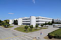
Administration building of the Opel factory

AHS Heustadelgasse


_-_Opel-Werk,_Verwaltungsgeb%C3%A4ude_(2).JPG)

Web links
Individual evidence
- ↑ Opel-wien.at: History ; Retrieved June 22, 2014
- ↑ New home for Christophorus - wien.ORF.at. Retrieved February 5, 2018 .
- ↑ The conductor. Official cours book of the Austrian railways. , Verlag R. v. Waldheim, Vienna 1901, p. 55, timetable 26
- ^ Walter Krobot, Josef Otto Slezak, Hans Sternhart: Tram in Vienna the day before yesterday and the day after tomorrow , Verlag Josef Otto Slezak, Vienna 1972, ISBN 3-900134-00-6 , p. 305 ff.
Aspern |
Breitenlee |
Essling |
Hirschstetten |
Kagran |
Kaisermühlen |
Stadlau |
Süßenbrunn
Lobau (KG Kaiserebersdorf Herrschaft and KG Landjägermeisteramt)
Coordinates: 48 ° 13 ′ 4 ″ N , 16 ° 29 ′ 0 ″ E