Stadlau
| Stadlau | |
|---|---|
| coat of arms | map |
 |

|
Stadlau was until 1904 an independent municipality and is now a district of Vienna in the 22nd district of Vienna Danube city and one of 89 Vienna Katastralgemeinden .
geography
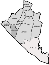
Stadlau bordered to the north Kagran and Hirschstetten , east to Aspern , in the south on the other side of the Danube located Leopoldstadt , the 2nd district, and on the west by Kaisermuehlen beyond the Old Danube . Part of the Danube Island is part of Stadlau. The cadastral community extends over an area of 499.44 hectares .
history
Stadlau was first mentioned in documents as Stadelouve (Stadel in der Au) in 1150 . Originally, Stadlau was a fiefdom of the Babenbergs . The residents were free, relatively wealthy farmers who owned the area between the banks of the Danube and today's pleasure house in the Prater . At that time, Stadlau was one of the most important places in Marchfeld , as the Stadlauer Ufer was the starting point for the crossing to the Stubentorlände. After the Babenbergers had granted the people of Stadlau the “original right”, they could demand tolls for the goods transported across the Danube. In 1160 the place got its own parish church, to which the places Aspern, Deutsch-Wagram , Gerasdorf , Groß-Enzersdorf and Leopoldau belonged.
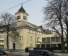
The church, which was consecrated to Saint George , was destroyed along with the site in 1438 (some sources give an earlier date) by a flood after a large ice rush . The church was then rebuilt in neighboring Kagran. As a result, Stadlau belonged to the Kagran parish . In 1795 a school with a bell tower was built, where at least the time of prayer and Vespers could be rung in.
Around 1820 Stadlau consisted of about 10 to 15 houses, which were in the form of a row village on both sides of today's Schickgasse (between Stadlauer Straße and Konstanziagasse). A tributary of the Danube was about 400 to 500 meters away at that time.
The Viennese Danube regulation carried out from 1870 to 1875 led, among other things, to the drainage of branches of the Danube near Stadlau. In 1870, the Stadlauer Bahnhof was opened for Laaer Ostbahn and Marchegger Ostbahn ; subsequently the village developed into a railway and industrial town. The Stadlauer Friedhof was built in 1875 , before that the Stadlauers buried their dead in what was then the churchyard of the Kagran parish church.
In 1904 the 21st district of Vienna ( Floridsdorf ) was founded, made up of the towns of Floridsdorf , Jedlesee , Großjedlersdorf , Donaufeld , Leopoldau, Kagran, Hirschstetten, Aspern and Stadlau.
In 1924 a new church was built by the Salesians . The church initially remained a branch church of the parish of St. Georg in Kagran. It was not until 1940 that Stadlau was raised to its own parish.
After Austria by 13 March 1938 to the German Reich connected had been, they separated in establishing Greater Vienna on 15 October 1938 places Aspern, Hirschstetten and Stadlau of 21 district and formed with them and with Breitenlee , Essling , Süßenbrunn and 15 other Marchfeld communities the huge 22nd district, Groß-Enzersdorf . The Laaer Ostbahn formed the border to the 21st district until 1954. In 1954 most of the Marchfeld communities were transferred back to Lower Austria ; Breitenlee, Essling and Süßenbrunn stayed with Vienna. The district boundary 21/22 was now drawn further northwest in continuation of the district boundary 2/20, so that Kagran and Kaisermühlen came to the new 22nd district. Since Groß-Enzersdorf had left, Donaustadt was chosen as the new district name, a name that had been used eighty years earlier after the Danube regulation for the new building area in the 2nd district near the Reichsbrücke , but did not prevail there and was therefore dropped.
Sports
Two of the most traditional sports clubs in Stadlau are the WAT Stadlau , which was founded in 1914 as a workers gymnastics club in Stadlau , and the soccer club FC Stadlau , which was founded in 1913 as Normania .
traffic
In Stadlau there are the following underground stations on the U2 underground line (from south to north):
- Danube city bridge
- Stadlau : The Vienna Stadlau train station is the largest in the 22nd district. The S-Bahn line S80, regional trains, which run on the Marchegger Ostbahn in the direction of Marchegg and Pressburg , and several bus lines also stop here .
- Hardeggasse
The Vienna Lobau S-Bahn station, which was closed in December 2014, was also located in Stadlau. The Vienna Erzherzog-Karl-Straße station is on the border with Kagran and Hirschstetten, where the two branches of the Eastern Railway north of the Danube fork.
The Südosttangente motorway crosses the district. The Prater Bridge , the northeastern part of which is in Stadlau, is part of this motorway.
literature
- Birgit Trinker, Michael Strand: Vienna district handbooks. 22nd district - Donaustadt . Pichler Verlag, Vienna 2001, ISBN 3-85431-231-8
Web links
Coordinates: 48 ° 13 ' N , 16 ° 28' E


