Kagran
| Kagran | |
|---|---|
| coat of arms | map |

|

|
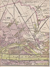
Kagran [ KAGRAN ] was until 1904 an independent municipality and is now a district of Vienna in the 22nd district of Vienna Danube city and one of 89 Vienna Katastralgemeinden . A small part of Kagran is in the 21st district of Floridsdorf .
geography
Kagran borders in the east on Breitenlee and Hirschstetten , in the south on Kaisermühlen and Stadlau , in the west on Leopoldau and Donaufeld and in the north on Süßenbrunn and the Lower Austrian town of Gerasdorf near Vienna . The cadastral municipality extends over an area of 1078.87 ha , of which 5.17 ha are in the area of the Floridsdorf municipality.
history
Kagran was first mentioned in 1199 as Chagaran , which is derived from the related Wagram . The "waves edge of the Danube" called this name this district from times before the Danube regulation . From the period 1785-1821 satirical observations under the title Letters from an Eipeldauers to his master cousin in Kakran over d'Wienstadt (Eipeldau is the historical name of the northwestern neighboring village Leopoldau ). Since 1886 Kagran was served by the steam tramway line Augartenbrücke - Floridsdorf -Kagran - Groß-Enzersdorf ; the Floridsdorf-Kagran route is now used by tram lines 25 and 26.
In 1904/05, Kagran was incorporated into Vienna as part of the new 21st Viennese district, Floridsdorf. In Red Vienna were public housing and urban settlements erected. Between 1940 and 1945, executions by shooting were carried out at the Kagran firing range. Since 1954, Kagran has formed the 22nd district, Donaustadt, with seven other localities . Kagran remained village for a long time, but in the 1970s large residential complexes of the municipality of Vienna were built north-east of the historic village center on the Trabrenngrund , in Neukagran the Donauzentrum , Vienna's largest shopping center.
A stretch of beach on the New Danube , which was created in the 1970s and 1980s , is a particularly important tributary of the Danube in Vienna during floods , and was given the name Copa Cagrana by the media and later by the city administration . Since the renovation began in early 2018, the city administration has been calling the area Copa Beach .
traffic
Today this part of the district is the junction of the Danube city due to the Kagran underground station , the Danube center and the good connection to various motorways. The U1 underground line has been running to Leopoldau since September 2, 2006, and Kagran has two more underground stations at Kagraner Platz and Rennbahnweg .
coat of arms
The St. George represented on the municipal coat of arms slaying the dragon (with golden armor and a silver horse and beaten dragon on the back lying) in the middle of the eight sub-fields of the original eight Marchfeld communities this former Angersdorf. Today St. George is the patron saint of the Kagran parish .
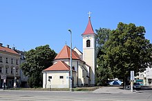
Parish Church of St. George
The church can be traced back to the 15th century as a single-nave village church. The Gothic choir was built in 1438 and the nave was extended in 1642 . The core of the tower with the local stone structure is also Gothic, the bell storey and pointed helmet are from the 17th century. The original Kagran cemetery was located around the church , which was closed in 1890 and abandoned in 1902. Most of the furnishings date from the 18th century.
Web links
- Kagran in the Vienna History Wiki of the City of Vienna
Individual evidence
- ↑ Conversion of the Copa Cagrana begins. In: wien.orf.at. January 17, 2018, accessed November 27, 2018 .
- ^ Kagran Church in the Vienna History Wiki of the City of Vienna
Coordinates: 48 ° 15 ' N , 16 ° 27' E


