Duisburg motorway junction
| Duisburg motorway junction | |
|---|---|
|
|
|
| map | |
| location | |
| Country: | Germany |
| State : | North Rhine-Westphalia |
| Coordinates: | 51 ° 26 '47 " N , 6 ° 46' 43" E |
| Height: | 28 m above sea level NN |
| Basic data | |
| Design type: | Shamrock |
| Bridges: | 1 (motorway) / 2 (other) |
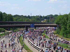
| The A 40 in front of the Duisburg junction during the still-life Ruhrschnellweg . |
|
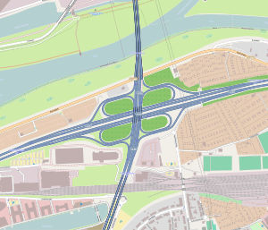
The motorway junction Duisburg (abbreviation: AK Duisburg ; short form: Kreuz Duisburg ) is a motorway junction in North Rhine-Westphalia in the Rhine-Ruhr metropolitan region . It connects the federal highway 40 ( Ruhrschnellweg ; E 34 ) with the federal highway 59 ( Duisburg - Bonn ).
geography
The motorway junction is located in the urban area of the city of Duisburg . The closest districts are Duissern , Meiderich , Altstadt and Kaßlerfeld . It is located about 25 km north of Düsseldorf , about 1.5 km northeast of Duisburg city center and about 15 km west of Essen .
In this area, the A 40 runs parallel to the Ruhr . This is crossed by the A 59 together with the Rhine-Herne Canal and the Duisburg-Ruhrorter ports by the Berlin bridge , which connects to the motorway junction to the north. In the east, the Ruhr tunnel of the Duisburg Stadtbahn passes under the A40 and then runs parallel to the A59.
The Duisburg motorway junction has junction number 13 on the A 40 and number 9 on the A 59.
Design and state of development
The A 40 has been expanded to six lanes, the A 59 is being expanded to six lanes. All connecting ramps are single-track.
The motorway junction was laid out as a clover leaf .
Traffic volume
In 2015 the cross was used by around 157,000 vehicles every day.
| From | To | Average daily traffic volume |
Share of heavy goods traffic |
||||
|---|---|---|---|---|---|---|---|
| 2005 | 2010 | 2015 | 2005 | 2010 | 2015 | ||
| AS Duisburg-Häfen (A 40) | AK Duisburg | 89,500 | 91,900 | 77,600 | 15.0% | 16.2% | 14.6% |
| AK Duisburg | AK Kaiserberg (A 40) | 92,300 | 101,300 | 101,300 | 11.7% | 12.8% | 12.8% |
| AS Duisburg-Ruhrort (A 59) | AK Duisburg | 90,000 | 72,100 | 65,600 | 6.5% | 7.1% | 5.9% |
| AK Duisburg | AS Duisburg-Duissern (A 59) | 69,400 | 51,700 | 69,300 | 4.6% | 4.5% | 5.0% |
Individual evidence
- ↑ Manual road traffic census 2005. (PDF) Results on federal motorways. BASt Statistics, 2005, accessed on November 30, 2017 .
- ↑ Manual road traffic census 2010. (PDF) Results on federal motorways. BASt Statistics, 2010, accessed on November 30, 2017 .
- ↑ Manual road traffic census 2015. (PDF) Results on federal motorways. BASt Statistics, 2015, accessed on November 30, 2017 .

