Bad Friedrichshall (district)
|
Bad friedrichshall
City of Bad Friedrichshall
Coordinates: 49 ° 13 ′ 39 ″ N , 9 ° 12 ′ 37 ″ E
|
|
|---|---|
| Height : | 178 m |
| Area : | 19.08 km² |
| Residents : | 13,971 |
| Population density : | 732 inhabitants / km² |
| Postal code : | 74177 |
| Area code : | 07136 |
|
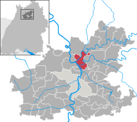
The town of Bad Friedrichshall in the Heilbronn district.
|
|
Bad Friedrichshall is a district of the city of Bad Friedrichshall in the Heilbronn district in northern Baden-Württemberg . It includes the former communities of Kochendorf , Jagstfeld and Hagenbach .
geography
The Bad Friedrichshall district borders the Duttenberg and Untergriesheim districts in the north . In the south to the Plattenwald district . In the west the district borders on Bad Wimpfen and Untereisesheim , in the east on Oedheim .
history
The city of Bad Friedrichshall was created between 1933 and 1935 through the merger of the communities of Kochendorf, Jagstfeld and Hagenbach. In the area between these districts, a new town center has been formed with an extensive industrial area, and a closed settlement area has emerged through the designation of a building area along Hagenbacher Straße between Kochendorf and Hagenbach.
In its main statute, the city has identified the former founding communities together as the Bad Friedrichshall district , which includes the districts of these former communities (excluding the Plattenwald district that was created in 1989 on the Kochendorf district).
The districts of Bad Friedrichshall , Duttenberg , Untergriesheim and Plattenwald, which are shown in the main statute, form residential areas for the Unechte Teilorteschahl.
Population development
The following overview shows the population of the Bad Friedrichshall district according to the respective territorial status.
| year | Residents |
|---|---|
| 1939 | 5,062 |
| 1945 | 5,661 |
| 1950 | 7,300 |
| 1980 | 10,074 |
| 1985 | 10,067 |
| 1990 | 11.013 |
| 1995 | 11,752 |
| 2000 | 12.121 |
| 2005 | 13,014 |
| 2015 | 19,264 |
schools
The primary schools Kochendorf, Jagstfeld and Hagenbach are located in the district. The Bad Friedrichshall School Association (Otto Klenert School Bad Friedrichshall) and the Friedrich von Alberti Gymnasium are also here .
Economy and Infrastructure
traffic
Rail transport and public transport
The bad friedrichshall Hauptbahnhof (until 13 December 2014 Bahnhof Bad Friedrich-Jagstfeld ) is an important railway junction, the 1869-1920 also border station between the Grand Ducal Baden State Railways and the Royal Württemberg State Railways was. This can still be seen today from the widely stretched tracks, as the station building was in the middle until the Second World War.
At Bad Friedrichshall's main train station, the Elsenz Valley and Neckar Railway (from Heidelberg via Sinsheim or via Mosbach ) meet the Franconian Railway from Stuttgart to Würzburg . In addition, the Untere Kochertalbahn to Ohrnberg existed as a private railway of the WEG until 1993 .
The Bad Friedrichshall-Kochendorf station is another stop of the Frankenbahn, which is only served by regional or light rail vehicles. The Bad Friedrichshall-Kochendorf Nord station existed until the Lower Kochertal Railway was closed in December 1993 .
Since the expansion of the Heilbronn tram network in December 2014, the city has been served by the tram lines S41 and S42, which branch out in Bad Friedrichshaller Hauptbahnhof.
Local public transport is served by various bus routes that are integrated into the HNV transport association . These lines provide a connection to the main train station and the city center of Bad Friedrichshall from every district . This so-called city bus traffic means that no citizen has more than 500 meters to the next stop.
Road traffic
The Bad Friedrichshall district is connected to the motorway-like federal highway 27 ( Blankenburg (Harz) - Schaffhausen ) through the interchanges Bad Friedrichshall Mitte , Bad Friedrichshall Süd and Bad Friedrichshall-Jagstfeld . This connects the city directly with the federal motorway 6 .
shipping
The Neckar, on which the city is located, has been expanded for shipping since the 1920s and partially canalised; today it is classified as a federal waterway . In the southern part of the city there is a lock of the Neckar Canal.
Established businesses
The Southwest German salt works AG from 1899 to 1994 the salt mine Kochendorf operated while below Bad Friedrichshall Neckarsulm and around 12 million cubic meters of cavities created. Since the mine only has one shaft, a 3.7 km long underground connection to the Heilbronn facility of the same company was completed in 1984 as an additional evacuation option. In 2007, a second connecting route was built, over which landfill material is transported to the Heilbronn field after its completion. Between 1994 and probably 2015, the mine has been backfilled with rubble , hazardous waste and other waste . A visitor mine is still open, however, including a listed underground dome hall from the 1920s.
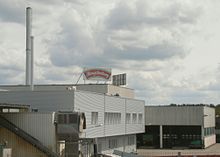
The company Hengstenberg GmbH & Co. KG produces canned food and vinegars in Bad Friedrichshall.
The company Hänel Büro- und Lagersysteme, founded in Bad Friedrichshall in 1953, with branches in Wiesentheid and Altstätten in Switzerland as well as several foreign branches is active in the production of automated warehouse and management systems . The Hänel gear factory, which manufactures gear wheels in Bad Friedrichshall, belongs to the same group of companies .
For a long time, one of the most important companies in the area was the Bachert company , which was originally founded in 1745 as a bell foundry in Dallau, but later had its headquarters in Bad Friedrichshall (district of Kochendorf) and was also active in vehicle construction (fire fighting equipment) there before its Relocated to Karlsruhe.
Individual evidence
- ↑ City of Bad Friedrichshall: General Statute of July 22, 2014 , §§ 13 and 14 (PDF; 49.4 kB)
- ↑ - City of Bad Friedrichshall - Lively city on the Neckar, Jagst and Kocher. Retrieved August 12, 2018 .
- ^ Salzstadt-Aktuell, January 2015 - Local public transport


