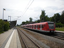
Taufkirchen stop
| Taufkirchen | |
|---|---|
| Data | |
| Operating point type | Breakpoint |
| Platform tracks | 2 |
| abbreviation | MTU |
| opening | October 10, 1898 |
| location | |
| City / municipality | Taufkirchen |
| country | Bavaria |
| Country | Germany |
| Coordinates | 48 ° 3 '4 " N , 11 ° 36' 32" E |
| Railway lines | |
| Railway stations in Bavaria | |
The Taufkirchen stop is a Deutsche Bahn stop on the Munich East – Deisenhofen line in Taufkirchen . The stop is served by the S3 line of the Munich S-Bahn , which runs between Mammendorf and Holzkirchen . The former station building is registered as a monument in the Bavarian list of monuments.
construction
Taufkirchen train station has two partially covered platforms, with all trains in the direction of Munich (Maisach and Mammendorf) stopping on platform 1 and all trains to Holzkirchen on platform 2 .
Next to platform 2 is bus platform 1, where line 241 stops, and next to platform 1 is the second bus platform with line 225.
The former sidings and freight facilities have been removed.
Reception building
The station building to the east of the route, erected when it was built in 1898, is a two-story historicizing bright brick building with a crooked roof. It is used privately today (2019). Like the single-storey outbuilding, partly wood-clad brick building with a flat hipped roof, and the single-storey former goods shed, brick building with a gable roof, it is a listed building.
traffic
The Taufkirchen stop is served every 20 minutes by the S-Bahn line S3 , which runs between Mammendorf and Holzkirchen . Neighboring stations are the Unterhaching stop in the direction of Mammendorf and the Furth stop in the direction of Holzkirchen.
| line | course | Tact |
|---|---|---|
|
|
Mammendorf - Malching - Maisach - Gernlinden - Esting - Olching - Gröbenzell - Lochhausen - Langwied - Pasing - Laim - Hirschgarten - Donnersbergerbrücke - Hackerbrücke - Hauptbahnhof - Karlsplatz (Stachus) - Marienplatz - Isartor - Rosenheimer Platz - Ostbahnhof - St.-Martin-Straße - Giesing - Fasangarten - Fasanenpark - Unterhaching - Taufkirchen - Furth - Deisenhofen - Sauerlach - Otterfing - Holzkirchen | 20 min |
The stop is connected to the MVV regional bus lines 225 and 241. There are two different Park & Ride facilities, which together have a capacity of 160 seats.
literature
- Georg Paula , Timm Weski: District of Munich (= Bavarian State Office for Monument Preservation [Hrsg.]: Monuments in Bavaria . Volume I.17 ). Karl M. Lipp Verlag, Munich 1997, ISBN 3-87490-576-4 , p. 158 .
Web links
- Taufkirchen station . In: www.mvv-muenchen.de , Munich Transport and Tariff Association
- Taufkirchen . In: www.bahnhof.de , Deutsche Bahn AG
- Taufkirchen . In: www.deutschebahn.com , Deutsche Bahn AG
Individual evidence
- ↑ List of monuments for Taufkirchen (PDF) at the Bavarian State Office for Monument Preservation, accessed on February 8, 2019, monument number D-1-84-145-9 .
- ^ Bahnhof Taufkirchen in the Bavarian Monument Atlas, accessed on February 8, 2019
- ↑ Entry in the Bavarian Monument Atlas

