Champigneulles – Sarralbe railway line
| Champigneulles – Sarralbe | |||||||||||||||||||||||||||||||||||||||||||||||||||||||||||||||||||||||||||||||||||||||||||||||||||||||||||||||||||||||||||||||||||||||||||||||||||||||||||||||||||||||||
|---|---|---|---|---|---|---|---|---|---|---|---|---|---|---|---|---|---|---|---|---|---|---|---|---|---|---|---|---|---|---|---|---|---|---|---|---|---|---|---|---|---|---|---|---|---|---|---|---|---|---|---|---|---|---|---|---|---|---|---|---|---|---|---|---|---|---|---|---|---|---|---|---|---|---|---|---|---|---|---|---|---|---|---|---|---|---|---|---|---|---|---|---|---|---|---|---|---|---|---|---|---|---|---|---|---|---|---|---|---|---|---|---|---|---|---|---|---|---|---|---|---|---|---|---|---|---|---|---|---|---|---|---|---|---|---|---|---|---|---|---|---|---|---|---|---|---|---|---|---|---|---|---|---|---|---|---|---|---|---|---|---|---|---|---|---|---|---|---|---|
|
Overpass structure at Benestroff for changing lanes.
| |||||||||||||||||||||||||||||||||||||||||||||||||||||||||||||||||||||||||||||||||||||||||||||||||||||||||||||||||||||||||||||||||||||||||||||||||||||||||||||||||||||||||
| Route number (SNCF) : | 97,000 | ||||||||||||||||||||||||||||||||||||||||||||||||||||||||||||||||||||||||||||||||||||||||||||||||||||||||||||||||||||||||||||||||||||||||||||||||||||||||||||||||||||||||
| Route length: | 82.5 km | ||||||||||||||||||||||||||||||||||||||||||||||||||||||||||||||||||||||||||||||||||||||||||||||||||||||||||||||||||||||||||||||||||||||||||||||||||||||||||||||||||||||||
| Gauge : | 1435 mm ( standard gauge ) | ||||||||||||||||||||||||||||||||||||||||||||||||||||||||||||||||||||||||||||||||||||||||||||||||||||||||||||||||||||||||||||||||||||||||||||||||||||||||||||||||||||||||
| Maximum slope : | 11 ‰ | ||||||||||||||||||||||||||||||||||||||||||||||||||||||||||||||||||||||||||||||||||||||||||||||||||||||||||||||||||||||||||||||||||||||||||||||||||||||||||||||||||||||||
|
|||||||||||||||||||||||||||||||||||||||||||||||||||||||||||||||||||||||||||||||||||||||||||||||||||||||||||||||||||||||||||||||||||||||||||||||||||||||||||||||||||||||||
The Champigneulles – Sarralbe (German actually Champigneulles-Saaralben ) railway line was a double-track, non-electrified railway line in Lorraine .
It was inaugurated on November 1, 1881 for both freight and passenger traffic. Passenger traffic was discontinued as early as 1970 and freight traffic was gradually discontinued between 1972 and 1990. The course book number 232 of the Deutsche Reichsbahn in the period up to 1918 shows a main route . In the second administrative period for the Reichsbahndirektion Saarbrücken (1940-1944), the route named 268a was already of minor importance. The French railway administration SNCF named the line 13 9 . Today it is administered with 97,000 .
history
In February 1869, the construction work began on the track, the cities of Paris and Sarreguemines ( French Sarreguemines should connect) with each other. The shortest route was via Nancy , where the Paris – Strasbourg line had existed since 1852 , and Château-Salins . The city of Chambrey ( German: Kambrich ), the last city before Moncel on the new German-French border, was also very interested in an efficient railway line. The Franco-German War initially prevented further work. They were not resumed until 1873. Until the First World War , however, only the section between Saargemünd and Bénestroff ( Bensdorf in German ) was double-tracked, although the buildings for the entire route were already double-tracked. The overpass structure , which is still in the forest a few kilometers west of Bénestroff and which was supposed to enable crossing-free lane changes in the transition of the driving regulations in the individual countries , is due to this delayed construction method.
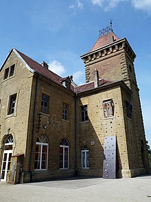
The stations on the German side of the border were much more representative than those on the French. In this sense, Metz's main train station functioned as a kind of lighthouse . The similarities in the construction between Saargemünd , Bénestroff and Chambrey are particularly striking, all of which have a square stone clock tower on a rectangular base, which was always placed next to the reception building. This elevated, hip-roofed tower looks particularly defensive, just like the overall appearance of the neo-Romanesque buildings like medieval castles.
Web links
- Etienne Biellmann: History of the railway stations (French)
- Map of the Champigneulles – Chambrey section with the former border line
literature
- Jean-Marc Dupuy: Gares et tortillards de Lorraine, Editions Cheminements, L'apart-Verlag 2009, ISBN 9782360370016 , p. 152ff
Individual evidence
- ↑ Bulletin des transports internationaux par chemins de fer: Journal for international rail traffic, volumes 71-72, Office centrale des transports internationaux par chemins de fer , January 1, 1905, p. 256; Impr. Friedli, 1963
- ↑ Etienne Biellmann: History of the railway stations (French)
- ↑ Reich course book page from 1944


