Barrow-in-Furness
| Barrow-in-Furness | |
|---|---|
|
|
|
| Basic data | |
| region | North West England |
| Ceremony county | Cumbria |
| Trad. county | Lancashire |
| surface | 77.87 km² |
| population | 71,980 ( 2001 ) |
| Website | [1] |
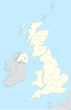
Barrow-in-Furness is a town in Cumbria in north-west England . It is the capital of the Borough of Barrow-in-Furness and has around 71,980 inhabitants (2001). The port city, which used to be part of the county of Lancashire , is one of the UK's major industrial centers . Barrow-in-Furness was still a small village around 1850 and has grown many times over within 20 years. At times it owned the largest steel mill in the world and developed into a center of shipbuilding. The port of Barrow is therefore still of great importance today.
The city is on Morecambe Bay across from Walney Island . The city is connected to the offshore island by the Jubilee Bridge, a bascule bridge . To the northeast is the Lake District .
history

The name Barrow is probably a falsification of an Old Norse term that stands for a bare island. This probably means the island of Barrow Island, which today forms part of the docks. A second theory says that the name is derived from the Old Norse barrey (= Barr Island), where barr is the original Celtic name and means promontory.
During the Middle Ages, the area was dominated by the powerful monks who lived in Furness Abbey , in close proximity to the modern city of Barrow. Until 1845 Barrow was just one of several small villages on the Furness Peninsula , the few hundred inhabitants lived from agriculture and fishing. Access to the village was difficult, with the peninsula surrounded on three sides by the treacherous shallows of Morecambe Bay and the mouth of the River Duddon , and on the fourth side by the mountains of the Lake District.
This changed in 1846 with the construction of the Furness Railway and the establishment of a railway ferry to Fleetwood , where connection to the rest of the railway network existed; from 1854 a continuous connection existed. Thanks to the mining of iron ore in the numerous mines , the tranquil little village grew into a town within a few years. In 1881 Barrow-in-Furness already had 47,000 inhabitants. The city received the status of a Municipal Borough in 1867 and a County Borough in 1889 .
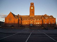
Barrow-in-Furness is one of the few planned cities in England. The square, tree-lined streets are lined with stately terraced houses. The development plan goes back largely to James Ramsden , an industrialist and co-owner of the Furness Railway. The docks were built on Barrow Island and the first steamship was launched in 1870. At the end of the 19th century, the railway company owned the town hall built in Gothic style, parts of the shipyard and extensive residential areas. In 1931 the population peaked at 74,000.
Since 1985 the natural gas reserves in Morecambe Bay and the Irish Sea have been exploited and pumped to Barrow-in-Furness. There the gas is forwarded to the national distribution network. The end of the Cold War resulted in decreased demand for warships and submarines. The city went into decline; Whereas at the beginning of the 1980s over 20,000 workers were still employed in the shipyard, in 2000 there were just under 3,000.
climate
- The highest temperature recorded: 33.3 ° C (92 ° F )
- The lowest recorded temperature: -11.1 ° C (12 ° F)
| month | Average rainfall |
|---|---|
| January | 7.12 cm |
| February | 6.74 cm |
| March | 6.35 cm |
| April | 5.42 cm |
| May | 5.51 cm |
| June | 6.14 cm |
| July | 5.64 cm |
| August | 6.83 cm |
| September | 8.61 cm |
| October | 11.05 cm |
| November | 9.19 cm |
| December | 8.53 cm |
| average | recording | |||
|---|---|---|---|---|
| month | minimum | maximum | minimum | maximum |
| January | 4 / 39.2 | 7 / 44.6 | −10 / 14 | 12.7 / 55 |
| February | 4 / 39.2 | 8 / 46.4 | −8.9 / 16 | 13.9 / 57 |
| March | 4 / 39.2 | 9 / 48.2 | −9.4 / 15 | 18.9 / 66 |
| April | 6 / 42.8 | 12 / 53.6 | −4.4 / 24 | 22.2 / 72 |
| May | 9 / 48.2 | 15/59 | −1.7 / 29 | 27.2 / 81 |
| June | 10/50 | 19 / 66.2 | 2.2 / 36 | 31.1 / 88 |
| July | 11 / 51.8 | 17 / 62.6 | 3.9 / 39 | 32.8 / 91 |
| August | 13 / 55.4 | 19 / 66.2 | 2.8 / 37 | 33.3 / 92 |
| September | 12 / 53.6 | 17 / 62.6 | 0/32 | 26.7 / 80 |
| October | 9 / 48.2 | 14 / 57.2 | −5 / 23 | 23.3 / 74 |
| November | 7 / 44.6 | 10/50 | −6.7 / 20 | 16.1 / 61 |
| December | 4 / 39.2 | 7 / 44.6 | −11.1 / 12 | 13.9 / 57 |
population
population
| Years | population |
|---|---|
| 1801 (count) | 1,958 |
| 1850 (estimate) | 5,000 |
| 1901 (estimate) | 67,354 |
| 1950 (estimate) | 77,000 |
| 2001 (census) | 71,980 |
religion
| religion | Total population |
| Christian | 58,322 |
| No religion | 7,769 |
| Religious community that was not given in the survey | 5,465 |
| Muslims | 1,820 |
| Jewish | 260 |
| other religion | 93 |
| Buddhist | 72 |
| Hindu | 46 |
| Sikh | 6th |
Other information
- The port of Barrow is home to one of the leading shipyards in England and the only submarine shipyard in England.
- In the port of Barrow is the largest naval shipbuilding hall in Europe (BAE Devonshire Dock Hall), which is longer than the tallest building in Europe ( Triumph Palace in Moscow ).
- Before the 1870s, Barrow was the most important steel industry location in the world.
- It is said that the first Japanese restaurant in England was opened in Barrow in the early 19th century.
- In 2002, Barrow suffered the worst Legionnaires' disease outbreak in the country, with 7 deaths and 172 illnesses.
- Barrow has the largest Filipino community of a city its size in the country
- Offshore are the Barrow and Ormonde offshore wind farms
Personalities
- Aim (* 1970), musician, DJ and producer
- Glenn Cornick (1947-2014), rock musician
- William Henry Eccles (1875–1966), physicist
- Emlyn Hughes (1947-2004), football player
- Kenneth L. Johnson (1925-2015), Professor of Mechanics
- Nigel Kneale (1922–2006), writer and screenwriter
- Gary Stevens (born 1963), soccer player
- Ron Suart (1920–2015), football player and coach
- David Tattersall (* 1960), cameraman
Web links
Coordinates: 54 ° 7 ′ N , 3 ° 13 ′ W


