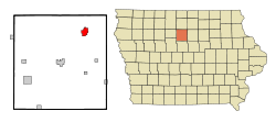
Belmond
| Belmond | |
|---|---|
|
Location in Iowa
|
|
| Basic data | |
| Foundation : | 1856 (created) 1881 (incorporated) |
| State : | United States |
| State : | Iowa |
| County : | Wright County |
| Coordinates : | 42 ° 51 ′ N , 93 ° 37 ′ W |
| Time zone : | Central ( UTC − 6 / −5 ) |
| Residents : | 2,376 (as of 2010) |
| Population density : | 322 inhabitants per km 2 |
| Area : | 7.38 km 2 (approx. 3 mi 2 ) |
| Height : | 359 m |
| Postal code : | 50421 |
| Area code : | +1 641 |
| FIPS : | 19-05680 |
| GNIS ID : | 454502 |
| Website : | www.belmondiowa.com |
| Mayor : | Al Mattison |
Belmond is a small town (with the status " City ") in Wright County in the US -amerikanischen State Iowa . In 2010 , Belmond had 2,376 inhabitants, the number of which had decreased to 2,352 by 2013.
geography
Belmond is located in north-central Iowa on both sides of the Iowa River , a left tributary of the Mississippi .
The geographical coordinates of Belmond are 42 ° 50'46 "north latitude and 93 ° 36'51" west longitude. The urban area extends over an area of 7.38 km² and is mostly in the Pleasant Township . A smaller part of the urban area extends into the Belmont Township .
Neighboring towns to Belmond are Goodell (8.8 km north), Klemme (19.2 km in the same direction), Meservey (18.9 km northeast), Alexander (14.9 km east-southeast), Rowan (17.2 km south-southeast ), Galt (18.2 km south), Clarion (22.2 km southwest), and Kanawha (15.6 km northwest).
The closest major cities are the Twin Cities in Minnesota ( Minneapolis and Saint Paul ) (261 km north), Rochester in Minnesota (207 km northeast), Wisconsin's capital Madison (396 km east), Dubuque at the intersection of the states of Iowa, Wisconsin and Illinois (277 km east-southeast), Waterloo (138 km southeast), Cedar Rapids (241 km in the same direction), Iowa's capital Des Moines (150 km south), Nebraska's largest city, Omaha (362 km southwest), Sioux City (266 km west-southwest ) and South Dakota's largest city Sioux Falls (320 km west-northwest).
traffic
The US Highway 69 runs north-south direction as the main road through Belmond. All other roads are subordinate country roads, some unpaved roads and inner-city connecting roads.
A Union Pacific Railroad (UP) freight line runs north to south-west through the city of Belmond.
The Clarion Municipal Airport is a small airfield 23 km southwest. The nearest commercial airport is Des Moines International Airport (160 km south).
history
| Population development | |||
|---|---|---|---|
| Census | Residents | ± in% | |
| 1890 | 803 | - | |
| 1900 | 1234 | 53.7% | |
| 1910 | 1224 | -0.8% | |
| 1920 | 1797 | 46.8% | |
| 1930 | 1733 | -3.6% | |
| 1940 | 2109 | 21.7% | |
| 1950 | 2169 | 2.8% | |
| 1960 | 2506 | 15.5% | |
| 1970 | 2358 | -5.9% | |
| 1980 | 2505 | 6.2% | |
| 1990 | 2500 | -0.2% | |
| 2000 | 2560 | 2.4% | |
| 2010 | 2376 | -7.2% | |
| 2013 estimate | 2352 | -1 % | |
| 1890-2000 2010-2013 | |||
The place was founded in 1856 under the name Crown Point , the place of origin of one of the founders from Indiana . In 1881 the settlement was incorporated as an independent municipality and the first mayor was elected.
On October 14, 1966, an F5 tornado destroyed or damaged over 600 homes and 75 businesses. Six people were killed and much of the city was damaged.
population
According to the 2010 census , Belmond had 2,376 people in 1,047 households. The population density was 322 inhabitants per square kilometer. Statistically, 2.21 people lived in each of the 1047 households.
The racial the population was composed of 93.2 percent white, 0.1 percent African American, 0.2 percent Native American, 0.3 percent Asian, 0.2 percent Polynesian and 4.2 percent from other ethnic groups; 1.9 percent were descended from two or more races. Regardless of ethnicity, 12.1 percent of the population was Hispanic or Latino of any race.
23.4 percent of the population were under 18 years old, 53.2 percent were between 18 and 64 and 23.4 percent were 65 years or older. 51.9 percent of the population were female.
The average annual income for a household was 43,895 USD . The per capita income was $ 26,719. 6.0 percent of the population lived below the poverty line.
Individual evidence
- ↑ City of Belmond - Mayor & Council.Retrieved January 6, 2015
- ↑ a b c American Fact Finder. Retrieved January 6, 2015
- ↑ Distance information according to Google Maps. Accessed on January 6, 2015
- ↑ AirNav.com - Clarion Municipal Airport Retrieved on January 6, 2015
- ↑ State Data Center of Iowa (PDF; 86 kB) Retrieved January 6, 2015
- ↑ City of Belmond - History.Retrieved January 6, 2015
- ^ "Twister Kills 6 at Belmond," Cedar Rapids Gazette, October 15, 1966, p. 1 (available at Newspaperarchive.com).
