Up to now
| Up to now | ||
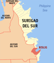
| Location of Bislig in the province of Surigao del Sur | ||
|---|---|---|

|
||
| Basic data | ||
| Region : | Caraga | |
| Province : | Surigao del Sur | |
| Barangays : | 24 | |
| District: | 2. District of Surigao del Sur | |
| PSGC : | 166803000 | |
| Income class : | 4. Income bracket | |
| Households : | 18,269 May 1, 2000 census
|
|
| Population : | 94,535 August 1, 2015 census
|
|
| Population density : | 233.4 inhabitants per km² | |
| Area : | 405 km² | |
| Coordinates : | 8 ° 13 ' N , 126 ° 19' E | |
| Postal code : | 8311 | |
| Area code : | +63 8622 | |
| Mayor : | Librado C. Navarro | |
| Website: | www.bislig.gov.ph | |
| Geographical location in the Philippines | ||
|
|
||
Bislig is a Filipino city of the 5th income category in the province of Surigao del Sur on the island of Mindanao . Bislig is located 152 km south of the provincial capital Tandag City and 158 km southeast of the regional capital Butuan City . Their neighboring communities are Hinatuan in the north and Lingig in the southeast.
Origin of name
The name of the place is derived from a climbing plant that belongs to the palm family and grows in abundance along the river banks of this area. The plant is known for its strong odor.
Legend has it that a royal couple found themselves in a life-threatening situation on one of their hunting expeditions when they tried to cross a river that had been swollen by the flood and were caught and carried away by the raging current. It is said that the hunters lost their last hope of survival when they caught the ¼ inch (6 mm) thick creeper and escaped to shore. As a token of their gratitude, they named the place after the creeper: Bislig .
geography
The city is located in the south of the Surigao del Sur province . It is bounded by the municipality of Hinatuan in the north, by Lingig in the southeast and by the province of Agusan del Sur in the southwest and west. In the northeast the coastline opens to the Pacific Ocean .
The district of Mangagoy is the commercial center of the city. This is where the national and international banks are based. The main tourist destination is the Tinuy-an Falls, known as the "Niagara Falls" of the Philippines. The water flows down three steps a total of 55 m. A sanctuary for the endangered Philippine eagle has been established within the urban area .
The urban area covers a total of 405 km². 216 km² of this is public forest area, 189.9 km² is agriculturally used land, settled or otherwise used and 6.61 km² consists of water.
The main rivers are the Bislig River, Pamanlinan River, and Burboanan River.
Language and religion
A local dialect is known as Kamayo (the pronunciation is uncertain) and is preserved as a cultural asset by the locals. Most of the residents, however, speak the Visayan languages Cebuano and Boholano .
The majority of the population is Roman Catholic . In addition, the religious communities of the Independent Philippine Church and the community of the Iglesia ni Cristo are also represented in the city area.
Barangays
So far it is politically divided into 24 barangays (districts).
|
|
Colleges
history
It is believed that the first inhabitants of Bislig came from the Agusan Valley , where they lived at times below the Magdiwata mountain range in the Mindanao hinterland . These people, known as the Manobo ethnic group, used spears, bows and arrows and lived as semi-nomads .
In the late 17th century they were ruled by a native Datu named Bagani , which means excellent leader . On the one hand, they were supposedly very brave, strong and willing to go to war; on the other hand, they grew crops such as rice , wheat and root vegetables .
At the turn of the next century, Spanish colonists and missionaries came to impose the rule of Spain and the power of the Catholic Church on the people. They were followed by Filipinos from the north, from the Visayas , Luzon and Negros , as members of the Spanish expeditionary forces.
At the end of the 19th century, Bislig was already a pueblo , a political administrative unit that belonged to a large territory that stretched from northeastern Mindanao down to the southeast to the pueblos Caraga and Man-ay of today's Davao Oriental . During the American administrative period, the village belonged to the formerly large province of Surigao, today divided into Surigao del Sur and Surigao del Norte .
With Executive Order No. 6, signed by Governor Francis Burton Harrison on December 28, 1920, Bislig was appointed on January 1, 1921 to an independently administered municipality.
Since that time, the village has expanded and developed, which led to the fact that on September 18, 2000 with the entry into force of Republic Act No. 8804, the municipality of Bislig was raised to the status of a town.
climate
The climate of Bislig falls under climate category II, which is not characterized by a pronounced dry period, but by heavy rainfall in the months of November to January. The city is outside the areas affected by typhoons. The driest months are July and August.
Attractions
- Tinuy-an cases
- Hagonoy Island
- LIBUAC source
- Lawigan Beach
- Forester's Park
Individual evidence
- ↑ NSCB - 2001 Factsheet - 12 New Cities Created , July-December 2000.
