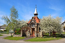
Bliszczyce
| Bliszczyce Bleischwitz |
||
|---|---|---|

|
|
|
| Basic data | ||
| State : | Poland | |
| Voivodeship : | Opole | |
| Powiat : | Głubczyce | |
| Gmina : | Branice | |
| Geographic location : | 50 ° 5 ' N , 17 ° 45' E | |
| Residents : | ||
| Telephone code : | (+48) 77 | |
| License plate : | OGL | |
| Economy and Transport | ||
| Next international airport : | Katowice | |
Bliszczyce (German: Bleischwitz ; Czech Blížčice ) is a village in the rural municipality Branice ( Branitz ) in the powiat Głubczycki in the Polish Voivodeship of Opole .
Geographical location
Bliszczyce is five kilometers northwest of Branice , 15 kilometers southwest of the district town Głubczyce ( Leobschütz ) and 67 kilometers south of the voivodeship capital Opole ( Opole ). The place is on the Czech-Polish border, which is formed by the oppa .
Neighboring towns are Lewice ( Löwitz ) in the northeast, Michałkowice ( Michelsdorf ) in the east and Branice in the southeast, beyond the border with the Czech Republic lies the town of Krnov ( Jägerndorf ) in the west .
history
Bleischwitz was first mentioned in a document in 1248. At that time it belonged to the Margraviate of Moravia . In 1279 the Bohemian Queen Kunigunde von Halitsch gave the place to the town of Jägerndorf . In 1318 Bleischwitz came together with Jägerndorf to the Přemyslid Duchy of Opava , which was a fiefdom of the Crown of Bohemia . After the division of the Duchy of Troppau in 1377 came Bleischwitz to the then newly founded Duchy Jägerndorf whose Regent Duke Johann I was.
For the year 1665 there is a school in Bleischwitz, which was given a new school building in 1850. Today's stone church was built in 1672, replacing a previous wooden building. After the First Silesian War , Bleischwitz, like most of Silesia, fell to Prussia in 1742 . Ecclesiastically it still belonged to the Diocese of Olomouc , whereby the part of the diocese that fell to Prussia was administered by the Katscher Commissariat founded in 1742 . With the reorganization of Prussia, Bleischwitz belonged to the province of Silesia from 1815 and was incorporated into the Leobschütz district from 1818 , with which it remained connected until 1945. For 1818 there are 27 farmers, 26 gardeners and 59 cottagers in Bleischwitz, as well as a non-profit and a Catholic church with a rectory. In 1865, the place had 32 farms, 77 plowed and 36 vacant houses, as well as two water mills and an oil brawler. At that time, 182 students were taught by two teachers at the school. Since 1874 the rural community Bleischwitz belonged to the Branitz district . In 1885 there were 1229 inhabitants.
In the referendum in Upper Silesia on March 20, 1921, 1,041 eligible voters voted to remain with Germany and no one for membership in Poland. Bleischwitz remained with the German Empire . In 1933 there were 1415 inhabitants. In 1939 the place had 1,351 inhabitants. Until 1945 the place was in the district of Leobschütz .
As a result of the Second World War, the German town since 1742 fell under Polish administration in 1945, was renamed "Bliszczyce" and joined the Silesian Voivodeship. The native German population was expelled . In 1950 Bliszczyce came to the Opole Voivodeship, in 1999 it was incorporated into the powiat Głubczycki.
Attractions
- Catholic parish church, 1672 and 1906
- Chapels
- Wayside crosses
- Monument to the fallen (First World War) in the cemetery
- Historic fire brigade wagon
Sons and daughters of the place
- Alfons Tracki (1896–1946), German Catholic clergyman, worked in Albania, a martyr
literature
- Georg Beier: Bleischwitz - District Leobschütz OS. Volume 1, 1982
- Georg Beier: Bleischwitz - District Leobschütz OS. Volume 2, 1986
Web links
Individual evidence
- ↑ See map in: Georg Beier: Die Dörfer des Kreis Leobschütz . Dülmen 1990, ISBN 3-87595-277-4 , p. 13
- ↑ Hugo Weczerka (Ed.): Handbook of historical sites . Volume: Silesia (= Kröner's pocket edition . Volume 316). Kröner, Stuttgart 1977, ISBN 3-520-31601-3 , family tables on p. 600-601.
- ↑ Belonging to the Leobschütz district
- ^ Geographical-statistical handbook on Silesia and the County of Glatz. Volume 2. Breslau and Jauer 1818
- ↑ Cf. Felix Triest : Topographisches Handbuch von Oberschlesien. Wroclaw 1865
- ^ Branitz district
- ^ Results of the referendum in Upper Silesia of 1921: Literature , table in digital form ( Memento from January 24, 2017 in the Internet Archive )
- ^ Michael Rademacher: German administrative history from the unification of the empire in 1871 to the reunification in 1990. Leobschütz district in Upper Silesia. (Online material for the dissertation, Osnabrück 2006).


