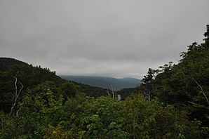
Buels Gore
| Buels Gore | ||
|---|---|---|
 |
||
| Location in Vermont | ||
|
|
||
| Basic data | ||
| Foundation : | November 4, 1780 | |
| State : | United States | |
| State : | Vermont | |
| County : | Chittenden County | |
| Coordinates : | 44 ° 12 ′ N , 72 ° 57 ′ W | |
| Time zone : | Eastern ( UTC − 5 / −4 ) | |
| Residents : | 30 (as of 2010) | |
| Population density : | 2.3 inhabitants per km 2 | |
| Area : | 12.9 km 2 (approx. 5 mi 2 ) of which 12.9 km 2 (approx. 5 mi 2 ) are land |
|
| Height : | 585 m | |
| Area code : | +1 802 | |
| FIPS : | 50-10300 | |
| GNIS ID : | 1462058 | |
| Website : | http://Vermont.gov | |
Buels Gore is a Unincorporated Gore in Chittenden County of the State of Vermont in the United States , with 30 inhabitants (according to census 2010).
geography
Geographical location
Buels Gore is located in the southeastern tip of Chittenden County, in the western foothills of the Green Mountains . There are only a few small watercourses in the Gores area. The largest area is Camel Hump State Park . The surface is hilly. The highest point is the 904 m high Stark Mountain .
Neighboring communities
All distances are given as straight lines between the official coordinates of the places from the 2010 census.
- North: Huntington , 2.4 mi
- East: Fayston , 5.0 mi
- South: Lincoln , 3 miles
- West: Starksboro , 4.8 km
climate
The average temperature in Buels Gore ranges from −11.0 ° C (12 ° Fahrenheit ) in January to 18.2 ° C (61 degrees Fahrenheit) in July. This makes the place about 2 degrees cooler compared to the long-term mean of Vermont. The snowfalls between October and May peak in January and are significantly higher than the mean snow depth in the USA. The daily sunshine duration is at the lower end of the range of values in the USA, in the period from September to December it is sometimes significantly lower.
history
Major Elias Buel was awarded the grant for a Town Coventry, at a point where, due to a measurement error, no more land was available. Therefore, on November 4, 1780, he was given a "flying grant". This enabled him to acquire land that had not yet been taken possession of at that time. He thus took possession of three parcels. Land in Orleans County, now Coventry , Coventry Leg or Coventry Gore (now part of Newport) and Buels Gore. Buels Gore was previously known as Huntington Gore, a triangular parcel south of Huntington.
This land grab was established on October 22, 1788, dated back to the date of the original grant. Buel and his partners had to pay the tax retrospectively for eight years. Buel lost interest and moved to New York.
In 1840, 18 people lived in Buels Gore. There was never a settlement of note, no post office, or representative in the Vermont legislature. Administration is carried out by a supervisor appointed by the state.
The Mad River Road Race runs through Buels Gore.
Population development
| Census Results - Buels Gore, Vermont | ||||||||||
|---|---|---|---|---|---|---|---|---|---|---|
| year | 1800 | 1810 | 1820 | 1830 | 1840 | 1850 | 1860 | 1870 | 1880 | 1890 |
| Residents | 18th | |||||||||
| year | 1900 | 1910 | 1920 | 1930 | 1940 | 1950 | 1960 | 1970 | 1980 | 1990 |
| Residents | 20th | 16 | 14th | 4th | 4th | 3 | 0 | 10 | 9 | 2 |
| year | 2000 | 2010 | 2020 | 2030 | 2040 | 2050 | 2060 | 2070 | 2080 | 2090 |
| Residents | 12 | 30th | ||||||||
Economy and Infrastructure
traffic
Buels Gore is traversed by Vermont State Route 14 in a west-east direction. There are no other roads in the Buels Gore area.
Public facilities
There is no hospital in Buels Gore. The University of Vermont Medical Center at Burlington is the closest hospital.
literature
- Zadock Thompson: History of Vermont, natural, civil and statistical, in three parts . 3rd volume. Chauncey Goodrich, Burlington 1842 ( limited preview in Google book search).
- Abby Maria Hemenway: The Vermont historical Gazetteer . 1st volume. Burlington, Vermont 1867.
Web links
- Profile of the community on the official portal www.Vermont.gov (English)
- Entry on VirtualVermont.com ( Memento from June 4, 2016 in the Internet Archive )
- Buels Gore on roadsidethoughts.com
Individual evidence
- ↑ Buels Gore in the Geographic Names Information System of the United States Geological Survey , accessed June 4, 2017
- ↑ Population data from the 2010 US Census in the American Factfinder
- ↑ Stark Mountain on Peakery.com ( page no longer available , search in web archives ) Info: The link was automatically marked as defective. Please check the link according to the instructions and then remove this notice. , accessed June 4, 2017
- ↑ Index of / geo. In: census.gov. Retrieved May 18, 2019 .
- ↑ Climate data for the neighboring Bolton at www.City-Data.com (English)
- ↑ a b c Buels Gore on Virtual Vermont ( Memento of the original from July 13, 2017 in the Internet Archive ) Info: The archive link was inserted automatically and has not yet been checked. Please check the original and archive link according to the instructions and then remove this notice. , accessed June 4, 2017
- ↑ Population 1800–2010 according to census results

