Burghofen
|
Burghofen
City of Waldkappel
Coordinates: 51 ° 7 ′ 8 ″ N , 9 ° 50 ′ 2 ″ E
|
|
|---|---|
| Height : | 265 m above sea level NHN |
| Area : | 5.07 km² |
| Residents : | 194 (Feb 17, 2015) |
| Population density : | 38 inhabitants / km² |
| Incorporation : | 1st October 1971 |
| Postal code : | 37284 |
| Area code : | 05656 |
|
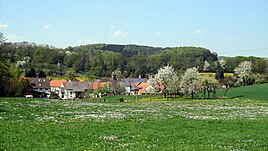
View from the south of Burghofen
|
|
Burghofen is a district of Waldkappel in the Werra-Meißner district in North Hesse .
Geographical location
Burghofen is about four kilometers southwest of the Waldkappel core town in the Stölzinger Mountains . It is located at the mouth of the Fischbach and Goldbach and the Schemmerbach . About 2 km southeast of the goat rises with a lookout tower. State road 3226 ( Schemmern- Burghofen- Friemen ) runs through the village .
history
The village was first mentioned in 1334 under the name Barkoben . Traces such as B. those of a castle over the place, suggest a settlement at the time of Charlemagne . In 1540 Burghofen had 150 inhabitants, in 1939 there were 696. In the Middle Ages, flax cultivation and linen weaving were practiced here.
In the course of the regional reform in Hesse , Burghofen came to the city of Waldkappel on October 1, 1971. It was three times district winner in the competition Our village should become more beautiful .
Individual evidence
- ↑ a b Burghofen, Werra-Meißner district. Historical local dictionary for Hessen. (As of February 8, 2016). In: Landesgeschichtliches Informationssystem Hessen (LAGIS).
- ↑ Burghofen district on the website of the city of Waldkappel, accessed in February 2016.
- ^ Federal Statistical Office (ed.): Historical municipality directory for the Federal Republic of Germany. Name, border and key number changes in municipalities, counties and administrative districts from May 27, 1970 to December 31, 1982 . W. Kohlhammer, Stuttgart / Mainz 1983, ISBN 3-17-003263-1 , p. 388 .
Web links
- Burghofen district on the website of the city of Waldkappel.
- Burghofen, Werra-Meißner district. Historical local dictionary for Hessen. In: Landesgeschichtliches Informationssystem Hessen (LAGIS).

