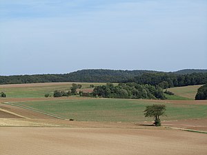
Goat Knuckles (Stölzinger Mountains)
| Goat club | ||
|---|---|---|
|
Goat club from the southwest |
||
| height | 445.4 m above sea level NHN | |
| location | at Rechtebach ; Werra-Meißner-Kreis , Hessen ( Germany ) | |
| Mountains |
Fulda-Werra-Bergland , Stölzinger Mountains |
|
| Coordinates | 51 ° 6 '32 " N , 9 ° 51' 30" E | |
|
|
||
| particularities | Lookout tower goat club | |
The goat club is 445.4 m above sea level. NHN high mountain of the Stölzinger Mountains in the East Hessian highlands . It is located near Rechtebach in the Werra-Meißner district in northern Hesse . The Ziegenküppel observation tower is on the mountain .
The mountain is not to be confused with the goat club 4.7 km (as the crow flies ) to the north in the Stolzhäuser ridge west of Waldkappel .
geography
location
The goat rises in the northeast part of northern Hesse in the Fulda-Werra-Bergland , part of the East Hessian mountains, and in the geo-nature park Frau-Holle-Land (Werratal.Meißner.Kaufunger Wald) . Its summit is 4 km south-south-west of the core town of Waldkappel , to whose urban area it belongs, and 6.5 km north-west of that of Sontra . The Waldkappel districts of Eltmannsee , Gehau , Schemmern , Burghofen , Friemen and Rechtebach as well as the Sontraer districts of Thurnhosbach and Diemerode are spread around the mountain.
Parts of the fauna-flora-habitat area Werra and Wehretal (FFH no. 4825-302; 244.8191 km² ) extend to the south - eastern flank of the Ziegenküppel .
The Goldbach rises to the west-southwest of the Ziegenküppel as a south-east tributary of the Schemmerbach , into which the Rechtebach , which springs to the east of the mountain and flows north, also flows. The Hosbach , which bends north in the nearby Stadthosbach and flows into the weirs , runs south of the mountain .
The premium hiking trail Waldkappeler Berge P17 runs over the summit of the mountain .
Natural allocation
The goat club belongs to the natural spatial main unit group Osthessisches Bergland (No. 35), in the main unit Fulda-Werra-Bergland (357) and in the subunit Sontra-Bergland (with Schlierbachswald) (357.9) to the natural area Hosbach-Sontra-Bergland (357.90) . Its landscape falls to the south and west into the Sontraer Land (357.31), to the northwest and north it leads over into the Schemmerbachgrund (357.32) - two natural areas of the subunit Sontraer Hügelland (357.3).
Observation tower
On the summit of the wooded Ziegenküppels, a wooden observation tower was first built in 1965 by members of the Burghofen Local History and Tourist Association , which was demolished in 2006 because it was dilapidated.
Since August 2009 a 13 m high wooden tower has been built there by companies and citizens from Burghofen and the surrounding area. The shell was finished on September 1st, 2009. In the spring of 2010, its viewing platform was given a roof. Access to the tower is from the northwest side. An outside metal staircase leads over 15 steps to the roof of the hut in the tower and from there over two further metal staircases with 16 and 17 steps to the 10 m high platform, which is provided with a webcam and is wide on the parapet Orientation boards are attached. A closed refuge, the Burghöfer Hut , with table and benches and space for around 20 to 25 people was set up on the ground floor of the tower . In 2016, a wooden terrace was built on the southwest side of the tower, which can accommodate up to 50 more people. There are antennas on the tower roof for connecting the surrounding villages to the Internet .
From the tower the view falls, for example, into the Stölzinger Mountains , to the highest mountain of these mountains, the Iceberg ( 583 m ), to the Hirschberg ( 643.4 m ) in the Kaufunger Forest and to the mountain range Hoher Meißner ( 753.6 m ). In addition, the view extends to the Großer Inselsberg in the Thuringian Forest and the Wartburg in Thuringia .
Web links
- In the Stölzinger Mountains , panoramic view from the observation tower (labeling of visual targets can be activated), on panorama-photo.net
Individual evidence
- ↑ a b c Map services of the Federal Agency for Nature Conservation ( information )
- ↑ Geoportal Hessen, see Hessian administrative units> Administrative boundary (municipality)
- ↑ Waldkappeler Berge P17 on the website of the German Hiking Institute eV
- ^ Hans-Jürgen Klink: Geographical land survey: The natural space units on sheet 112 Kassel. Federal Institute for Regional Studies, Bad Godesberg 1969. → Online map (PDF; 6.9 MB)
- ↑ a b c d e article A hike to the observation tower is worth it ( memento from November 29, 2014 in the Internet Archive ), on archive.org, from February 7, 2011, with a photo of the tower, from burghofen.de
- ↑ Film The tower on which (the) goat club stands , for the construction of the tower from 1965 with views of the landscape, on youtube.com
- ↑ Article New observation tower on the Ziegenküppel ( memento from November 29, 2014 in the Internet Archive ) (with photos from the construction), on archive.org, from September 14, 2009, from burghofen.de
- ↑ Article Turm am Ziegenküppel is blocked ( memento from November 29, 2014 in the Internet Archive ) (with photos of antennas and tower construction), on archive.org, from February 10, 2010, from burghofen.de
- ↑ a b New terrace is being planned in the Werra-Rundschau on August 9, 2016, accessed on April 10, 2018
- ↑ Information according to privately conducted explorations and measurements


