Castielfabib
| Castielfabib municipality | ||
|---|---|---|
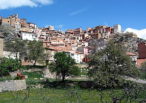
 View of Castielfabib
|
||
| coat of arms | Map of Spain | |

|
|
|
| Basic data | ||
| Autonomous Community : | Valencia | |
| Province : | Valencia | |
| Coordinates | 40 ° 1 ′ N , 1 ° 18 ′ W | |
| Height : | 927 msnm | |
| Area : | 106.29 km² | |
| Residents : | 317 (Jan 1, 2019) | |
| Population density : | 2.98 inhabitants / km² | |
| Postal code : | 46141 | |
| Municipality number ( INE ): | 46092 | |
| administration | ||
| Website : | www.castielfabib.es | |
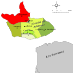
| Location of the municipality | ||

|
||
Castielfabib is a municipality in the north of the province of Valencia , in the Valencian Community in Spain. It is in the Comarca Rincón de Ademuz , an exclave of the Valencian Community, which is surrounded to the north by the province of Teruel in Aragon and to the south by the province of Cuenca ( Castile-La Mancha ).
Population development

- Source: INE , 1842-2007: Censuses
Web links
Commons : Castielfabib - collection of images, videos and audio files
Individual evidence
- ↑ Cifras oficiales de población resultantes de la revisión del Padrón municipal a 1 de enero . Population statistics from the Instituto Nacional de Estadística (population update).

