Chikballapur (District)
| Chikballapur District ಚಿಕ್ಕಬಳ್ಳಾಪುರ ಜಿಲ್ಲೆ |
|
|---|---|

|
|
| State | Karnataka |
| Division : | Bangalore |
| Administrative headquarters : | Chikballapur |
| Area : | 4,209 km² |
| Residents : | 1,254,377 (2011) |
| Population density : | 298 inhabitants / km² |
| Website : | chikballapur.nic.in |
The district of Chikballapur ( Kannada : ಚಿಕ್ಕಬಳ್ಳಾಪುರ ಜಿಲ್ಲೆ ) is a district in the Indian state of Karnataka . The administrative center is the eponymous city of Chikballapur .
geography
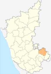
The district of Chikballapur is located in the southeast of Karnataka on the border with the state of Andhra Pradesh . Neighboring districts are Kolar in the southeast, Bengaluru Rural in the south, Tumkur in the west (all part of Karnataka) and in Andhra Pradesh Anantapur in the north and Chittoor in the east.
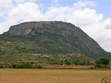
The Chikballapur District covers an area of 4,209 square kilometers. The district area consists of a plateau in the southernmost part of the Dekkan Plateau, from which the isolated foothills of the Eastern Ghats protrude. The most striking elevations are the Nandi Hills (also known as Nandidurg), about ten kilometers south of the district capital Chikballapur, the highest peak of which is 1,478 meters above sea level. The rivers Palar and Ponnaiyar , both of which flow into the Bay of Bengal , have their source in the Nandi Hills .
The district of Chikballapur is divided into the six taluks Bagepalli, Chikballapur, Chinthamani, Gauribidanur, Gudibanda and Sidlaghatta.
history
During the British colonial period , the area of today's Chikballapur district belonged to the Kolar district of the princely state of Mysore . After Mysore joined the Indian Union after Indian independence, the area of Chikballapur became part of the newly formed state of Mysore (renamed Karnataka in 1973 ) after the language borders of the Kannada . In 2007, the Chikballapur District split off as an independent district from Kolar District.
population
According to the 2011 Indian census, the Chikballapur district has 1,254,377 inhabitants. Compared to the last census in 2001, the population had grown by 7.2 percent and thus more slowly than the state average (15.7 percent). The population density of 209 inhabitants per square kilometer is below the average in Karnataka (319 inhabitants per square kilometer). 22.3 percent of the population of Chikballapur district live in cities. The degree of urbanization is thus lower than the average for the state (38.6 percent). At 70.8 percent, the literacy rate is also below the average in Karnataka (76.1 percent). 12.0 percent of the district's residents are classified as members of the tribal population ( Adivasi ) (2001 census).
Individual evidence
- ↑ Census of India 2011: Provisional Population Totals: Data Sheet (PDF; 1.7 MB) and Population and decadal growth rate by residence Persons. (PDF; 1.3 MB)
- ↑ Chikballapur District Website: District Profile. Area and Population 3. ( Memento of the original from June 19, 2009 in the Internet Archive ) Info: The archive link was inserted automatically and has not yet been checked. Please check the original and archive link according to the instructions and then remove this notice.
Web links
- The district website (English)
