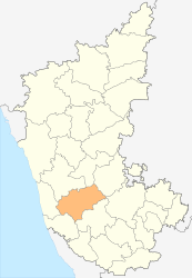
Chikmagalur (District)
| Chikmagalur District ಚಿಕ್ಕಮಗಳೂರು ಜಿಲ್ಲೆ |
|
|---|---|

|
|
| State | Karnataka |
| Division : | Mysore |
| Administrative headquarters : | Chikmagalur |
| Area : | 7,201 km² |
| Residents : | 1,137,753 (2011) |
| Population density : | 158 inhabitants / km² |
| Website : | chickmagalur.nic.in |
The district of Chikmagalur ( Kannada : ಚಿಕ್ಕಮಗಳೂರು ಜಿಲ್ಲೆ ; also: Chikkamagaluru ) is a district of the Indian state of Karnataka . The administrative center is the eponymous city of Chikmagalur .
geography
The district of Chikmagalur is located inland in the southern half of Karnataka. Neighboring districts are Shimoga and Davanagere in the north, Chitradurga in the northeast, Hassan in the southeast, Dakshina Kannada in the south and Udupi in the west.
The area of the Chikmagalur District is 7,201 square kilometers. The district has a share in two large scenic areas: A smaller part in the east belongs to the Maidan region , the part of the Dekkan highlands belonging to Karnataka , and presents itself as a gently undulating plateau. The rest of the district belongs to the mountainous region of Malnad and is taken by the Western Ghats , which border the Deccan from the west coast. To the north of the city of Chikmagalur, the Baba Budan Mountains protrude from the Western Ghats into the Dekkan Plateau. Here is the Mullayanagiri (1930 meters), the highest mountain in Karnataka. Numerous rivers have their source in the mountains, including the Tunga and the Bhadra , the two source rivers of the Tungabhadra .
The Chikmagalur district is divided into the seven taluks Chikmagalur, Kadur, Tarikere, Mudigere, Koppa, Narasimharajapura and Sringeri.
history
During the British colonial period , today's Chikmagalur district was known as the Kadur district after the city of Kadur and belonged to the princely state of Mysore . After Indian independence, the district came in 1956 as part of the States Reorganization Act to the newly created state of Mysore (since 1973 Karnataka) after the language borders of the Kannada and was renamed "District Chikmagalur".
population
According to the 2011 Indian census, the Chikmagalur district has 1,137,753 inhabitants. The stagnating population development is striking: Compared to the last census in 2001, the population shrank by 0.3 percent, while the population of the state of Karnataka grew by 17.5 percent in the same period. The Chikmagalur district is clearly rural: only 21.1 percent of the population lives in cities. The degree of urbanization is thus significantly lower than the mean value for the state (38.6 percent). The population density is one of the lowest in Karnatakas with 158 inhabitants per square kilometer and is well below the state average (319 inhabitants per square kilometer). At 79.2 percent, the literacy rate is above the mean value in Karnataka (76.1 percent).
According to the 2001 census, Hindus make up the majority of the residents of the district with 88.1 percent. For Islam to 8.3 percent of the population profess. There is also a small Christian minority of 2.4 percent.
economy
The Chikmagalur District is a coffee growing center in India. Legend has it that Sufi saint Baba Budan introduced coffee growing to India in the 17th century, brought the first coffee beans from the Hajj and planted them at his hermitage in the Baba Budan mountains named after him. During the colonial era, large coffee plantations were established in the mountains of the Chikmagalur district. Today coffee is grown on almost 70,000 hectares in the district.
Cities
| city | Population (2001) |
|---|---|
| Birur | 22.601 |
| Chikmagalur | 101.022 |
| Kadur | 30.802 |
| Koppa | 5.115 |
| Kudremukh | 8,095 |
| More tired | 8,962 |
| Narasimharajapura | 7,441 |
| Sringeri | 4,253 |
| Tarikere | 34,073 |
literature
- The Imperial Gazetteer of India. Volume 14: Jaisalmer to Karā. New edition. Clarendon Press, Oxford 1908, pp. 261–268 , keyword: Kadūr District .
Individual evidence
- ↑ Census of India 2011: Provisional Population Totals: Data Sheet (PDF; 1.7 MB) and Population and decadal growth rate by residence Persons. (PDF; 1.3 MB)
- ^ Census of India 2001: Basic Data Sheet. District Chikmagalur (17), Karnataka (29). (PDF; 55 kB)
- ↑ Chikmagalur District website: Horticulture crops. ( Memento of the original from June 19, 2009 in the Internet Archive ) Info: The archive link was inserted automatically and has not yet been checked. Please check the original and archive link according to the instructions and then remove this notice.
- ↑ Census of India 2001: Population, population in the age group 0-6 and literates by sex - Cities / Towns (in alphabetic order) ( Memento from June 16, 2004 in the Internet Archive )


