Cieszków
| Cieszków | ||
|---|---|---|

|
|
|
| Basic data | ||
| State : | Poland | |
| Voivodeship : | Lower Silesia | |
| Powiat : | Milicz | |
| Geographic location : | 51 ° 38 ' N , 17 ° 21' E | |
| Residents : | 1800 | |
| Postal code : | 56-330 | |
| Telephone code : | (+48) 71 | |
| License plate : | DMI | |
| Economy and Transport | ||
| Street : | Trzebnica - Krotoszyn | |
| Rail route : | Oleśnica – Chojnice | |
| Next international airport : | Wroclaw | |
| Gmina | ||
| Gminatype: | Rural community | |
| Surface: | 100.67 km² | |
| Residents: | 4680 (June 30, 2019) |
|
| Population density : | 46 inhabitants / km² | |
| Community number ( GUS ): | 0213012 | |
| Administration (as of 2007) | ||
| Community leader : | Ignacy Miecznikowski | |
| Address: | ul.Grunwaldzka 41 56-330 Cieszków |
|
| Website : | www.cieszkow.pl | |
Cieszków [ ˈʨɛʃkuf ] ( German Freyhan ) is a village and the seat of the municipality of the same name in Powiat Milicki ( Militsch district ) in the Polish Voivodeship of Lower Silesia .
Geographical location
The village is located in Lower Silesia , three kilometers southwest of the city of Zduny .
history

Freyhan was founded in the 15th century. Since 1628 it formed its own manor. It was spun off from the Militsch manor and was owned by the von Maltzan family until 1691 . Already in 1660 she obtained the rights of a minority rule . Subsequently, there were frequent changes of ownership, most recently Count Pückler . The castle was built in 1695.
In 1825, 491 residents lived in the market town, plus the castle town with 535 residents. In 1841 Freyhan lost the town charter. Because of its wooded surroundings, it became a popular excursion destination.
In 1945 Freyhan belonged to the Militsch district in the Lower Silesia province of the German Empire.
Towards the end of the Second World War , the region was occupied by the Red Army in the spring of 1945 . Shortly afterwards Freyhan was placed under Polish administration. Subsequently, the German residents of the village were evicted by the local Polish administration and replaced by Poles. The German village of Freyhan was renamed Cieszków .
Population numbers
- 1885: 551
- 1933: 1,361
- 1939: 1,376
Attractions
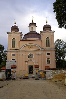
- Catholic church, built in 1753. It is a cross-domed building with an apse .
- Evangelical Church, completed in 1828.
Rural community
The rural community ( gmina wiejska ) Cieszków with an area of 100.67 km² and 4,672 inhabitants (2005) includes the following places:
- Biadaszka ( Peadauschke , incorporated into Freyhan from 1937 Freyhan Ost )
- Brzezina ( Breschine-Freyhan , 1936–45: Grünweiler )
- Cieszków ( Freyhan )
- Dziadkowo ( Altenau )
- Grzebielin ( Grebline , 1937–45: Langendamm )
- Guzowice ( Kuschwitz , 1937–45: Hellefeld NS )
- Góry ( Guhre , 1936–45: Konradshöh )
- Jankowa ( Jantkawe , 1937–45: Hansdorf )
- Jawor ( Jawor , 1936–45: Erlgrund )
- Nowy Folwark ( Neuvorwerk )
- Pakosławsko ( Bogislawitz , 1936–45: Altmühlgrund )
- Pustków ( Schadehof )
- Rakłowice ( Rackelsdorf )
- Sędraszyce ( Sandraschütz , 1936–45: Deutschwalde )
- Słabocin ( Schlabotschine , 1939–45: Grunewald )
- Trzebicko ( Strebitzko , 1936–45: Hochrode )
- Trzebicko Dolne ( Nieder-Strebitzko , 1936–45: Niederrode )
- Trzebicko-Piaski ( Santomischel / Residence to Strebitzko , 1936–45: Kleinrode )
- Ujazd ( Ujast , 1935–45: Kreisau )
- Wężowice ( Wensewitz )
- Zwierzyniec ( Thiergarten )
- Zymanów (formerly "Siemianów"; Sower's Court )
traffic
Cieszków is located on the Oleśnica – Chojnice railway with the no longer served stops Cieszków and Rakoniewice Milickie (in the district of Rakłowice).
Sons and daughters of the place
- Johann Moritz von Strachwitz (1721–1781), Apostolic Vicar, Vicar General and Auxiliary Bishop in Breslau
- Leopold von Luck (1740–1813), Prussian major general
- Arved von Teichman and Logischen (1829–1898), royal Prussian lieutenant general
- Mark G. von Pückler (* 1940), German lawyer and specialist author
Web links
Individual evidence
- ↑ population. Size and Structure by Territorial Division. As of June 30, 2019. Główny Urząd Statystyczny (GUS) (PDF files; 0.99 MiB), accessed December 24, 2019 .
- ^ A b c Michael Rademacher: German administrative history from the unification of the empire in 1871 to the reunification in 1990. militsch.html. (Online material for the dissertation, Osnabrück 2006).


