Zduny
| Zduny | ||
|---|---|---|

|
|
|
| Basic data | ||
| State : | Poland | |
| Voivodeship : | Greater Poland | |
| Powiat : | Krotoszyn | |
| Geographic location : | 51 ° 39 ' N , 17 ° 23' E | |
| Height : | 119-158 m npm | |
| Residents : | 4512 (June 30, 2019) |
|
| Postal code : | 63-760 | |
| Telephone code : | (+48) 62 | |
| Economy and Transport | ||
| Next international airport : | Wroclaw | |
| Gmina | ||
| Gminatype: | Urban and rural municipality | |
| Gmina structure: | 6 school offices | |
| Surface: | 85.20 km² | |
| Residents: | 7560 (June 30, 2019) |
|
| Population density : | 89 inhabitants / km² | |
| Community number ( GUS ): | 3012063 | |
| Administration (as of 2013) | ||
| Community leader : | Wladyslaw Ulatowski | |
| Address: | Rynek 2 63-760 Zduny |
|
| Website : | www.zduny.pl | |
Zduny ( German 1943–1945 Treustädt ) is a city in Poland in the Greater Poland Voivodeship . It is the seat of the town and country municipality of the same name in the Powiat Krotoszyński .
history

The first documentary mention dates back to 1241. At that time it was a ducal village and was called Sdunkow . The name of the village should be derived from "the many potters [...] who once lived here". In 1261, with the permission of Duke Boleslaus the Pious of Greater Poland, Zduny was elevated to the status of a town under Neumarkt law . As a result of the Counter Reformation , a mass exodus from Silesia led to a significant influx of Protestants from around 1630 , which contributed to a significant expansion of Zduny by around 2000 settlers. Landlord Peter Sienuta allowed the establishment of the Neustadt Deutsch-Zduny and the Protestant parish in 1637. With a third settlement laid out as a town in 1647 under the name of Sienutowo, the other two were united in 1772 under the rule of the Sułkowski family . In 1703 the cities of Sienutowo and Deutsch-Zduny were largely destroyed by fire and rebuilt.
In 1793, at the Second Partition of Poland , the city became part of Prussia . At the end of the 18th century, the city had seven public buildings, two hospitals, an Evangelical and a Catholic church and 439 residential buildings, seven of which had a tile roof. From 1807 to 1815 Zduny belonged to the Duchy of Warsaw , then back to Prussia.
The connection to the rail network took place in 1894 with the Oels - Jarotschin connection of the Prussian State Railways . After the First World War , Zduny became part of the re-established Poland on January 10, 1920 . In September 1939 the city was occupied by the German Wehrmacht as part of the attack on Poland , on October 26th it was incorporated into the part of the German Reich, later called Reichsgau Wartheland , in violation of international law and renamed Treustädt on May 18th, 1943.
In the spring of 1945, towards the end of the Second World War , the area was occupied by the Red Army . Unless the German population fled before the end of the war, they were subsequently expelled by the local Polish administrative authorities .
Religions
With the approval for the establishment of the Protestant parish, the first Protestant church was built as a wooden structure in 1637. After it was destroyed by fire in 1789, the next church was built as a plastered brick building with double wooden galleries according to plans by the Wroclaw builder JF Hansen and consecrated on November 18, 1792. The church was used as a warehouse until 1989 after the end of World War II.
Population development
| year | 1865 | 1875 | 1880 | 1890 | 1905 | 1910 | 1993 | 2002 |
|---|---|---|---|---|---|---|---|---|
| Residents | 3300 | 3352 | 3323 | 3477 | 3285 | 3431 | 4411 | 4421 |
| year | 2005 | 2006 | 2007 | 2008 | 2009 | 2010 | 2011 | 2016 |
| Residents | 4461 | 4505 | 4515 | 4500 | 4498 | 4498 | 4514 | 4565 |
The population development is shown graphically below.

In Zduny in 1890, 2,400 Protestants, 1,025 Catholics and 52 Jews were among the 3,477 inhabitants.
Town twinning
Zduny maintains a city partnership with the following cities :
Culture and sights
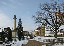
- baroque town hall, built in 1684
- Baroque church of St. Johannes, built 1719–1721
- Baroque-classical Protestant church built 1789–1792
local community
In addition to the city of Zduny, the city and rural community also includes six further districts ( German names, official until 1945 ) with a Schulzenamt .
Other localities in the municipality are:
- Dziewiąte ( Dziewionte )
- Hadrianów
- Ostatni Grosz ( Last Groschen )
- Piaski ( Piaski )
- Rochy ( revenge )
- Siejew ( Schönmühl )
- Szczerków ( Stscherkow )
- Trzaski ( Trzaski )
Economy and Infrastructure
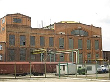
The most important industrial enterprise in the city was the sugar factory founded in 1882, which was taken over by Pfeifer & Langen KG after the turn of the millennium , but ceased operations in 2002. Zduny has a station on the Oleśnica – Chojnice railway line that is no longer used by passengers .
Personalities
sons and daughters of the town
- Ernst Daniel Adami (1716–1795), German conductor and Protestant theologian.
- Richard Pfeiffer (1858–1945), German hygienist, bacteriologist and immunologist.
- Bernhard Heinrich Irrgang (1869–1916), German organist and composer.
People who worked in Zduny
- Ludwig von Jazdzewski (1838–1911), Polish Catholic theologian and politician.
- Bolesław Jaśkowski (born December 19, 1884 in Łobżenica , Wyrzysk district, killed on November 10, 1939 near Gniewkowo near Inowrocław), Polish Catholic priest in Zduny from 1918 to 1926, founder of the Zduny people's team in the Greater Poland uprising , protector of the German Catholics in the Zdunyer parish.
literature
- Heinrich Wuttke : City book of the country Posen. Codex diplomaticus: General history of the cities in the region of Poznan. Historical news from 149 individual cities . Leipzig 1864, pp. 452-455.
Web links
Footnotes
- ↑ a b population. Size and Structure by Territorial Division. As of June 30, 2019. Główny Urząd Statystyczny (GUS) (PDF files; 0.99 MiB), accessed December 24, 2019 .
- ↑ a b c www.mapa.szukacz.pl , accessed on December 29, 2010
- ^ A b Heinrich Wuttke : City book of the country of Posen . Codex diplomaticus: General history of the cities in the region of Poznan. Historical news from 149 individual cities. Leipzig 1864, p. 452–455 ( google.de [accessed December 31, 2018]).
- ↑ a b Vossberg, FA: Book of Arms of the Cities of the Grand Duchy of Posen (1866), p. 18, online: www.bsb-muenchen-digital.de , accessed on February 28, 2011
- ↑ a b c d Julius Kohte : Directory of the art monuments of the province of Posen. Vol. III. The administrative districts of Posen, Berlin 1896, pp. 310–316 Online: PDF , accessed on December 29, 2010
- ↑ Land of the Great Rivers . From Poland to Lithuania. In: Rogall, Joachim (Hrsg.): German history in Eastern Europe . Siedler Verlag, Berlin 1996, ISBN 3-88680-204-3 , p. 136, 139 .
- ^ Adolf Warschauer : The Municipal Archives in the Province of Posen, Leipzig 1901, p. 285 , PDF file, accessed on January 9, 2011
- ↑ a b Michael Rademacher: German administrative history from the unification of the empire in 1871 to the reunification in 1990. Krotoschin district. (Online material for the dissertation, Osnabrück 2006).
- ↑ www.territorial.de , accessed on January 1, 2011
- ↑ Order about a change of place name in Reichsgau Wartheland in the ordinance sheet of the Reich Governor in Warthegau from May 18, 1943 (pdf; 1.9 MB), accessed on February 27, 2011
- ↑ ZDUNY.PL | Gmina i Miasto. (No longer available online.) Archived from the original on September 8, 2009 ; Retrieved December 29, 2010 (Polish).
- ^ Pierer's Universal Lexicon . tape 19 . Altenburg 1865, p. 538 ( zeno.org [accessed April 25, 2012]).
- ^ A b c Michael Rademacher: German administrative history from the unification of the empire in 1871 to the reunification in 1990. pos_krotoschin.html. (Online material for the dissertation, Osnabrück 2006).
- ^ Meyer's Large Conversational Lexicon . tape 20 . Leipzig 1909, p. 858 ( zeno.org [accessed April 25, 2012]).
- ^ Municipal directory Germany 1900. Kingdom of Prussia - Province of Posen - District of Posen - District of Krotoschin. In: www.gemeindeververzeichnis.de. Uli Schubert, December 9, 2018, accessed December 31, 2012 .
- ↑ a b c d e f g h Polska. In: pop-stat.mashke.org. 2019, accessed May 8, 2019 .
- ↑ The Genealogical Place Directory
- ↑ Cf. web link " Order about change of place names in Reichsgau Wartheland " - Krotoschin district
- ^ Lidl, Johann Jakob: Novissimum Silesiae Theatrum. In: mapy.mzk.cz. Map collection Moll, 1745, accessed January 5, 2019 .


