
Dato (Liquiçá)
| Date | |||
.jpg)
|
|||

|
|||
| Data | |||
| surface | 16.33 km² | ||
| population | 9314 (2015) | ||
| Chefe de Suco | Oscar da Silva (election 2009) |
||
| Aldeias | Population (2015) | ||
| Cabuilimo | 270 | ||
| Camalehohoru | 3,006 | ||
| Camalelara | 730 | ||
| Hecar | 198 | ||
| Laclolema | 449 | ||
| Lebuhei | 90 | ||
| Leopa | 3,320 | ||
| Lisa-Ico | 73 | ||
| Puquelara | 1.108 | ||
| Quirilelo | 70 | ||
|
|||

Dato is an East Timorese place and Suco in the administrative office of Liquiçá ( Liquiçá municipality ).
The district
Liquiçás district Dato is located in the north of the Sucos, at an altitude of 5 m . Here is the primary school of sucos, the Escola Primaria Casabauc .
The Suco
| Date | ||
| places | position | height |
| Cabuilimo | 8 ° 38 ′ S , 125 ° 21 ′ E | ? |
| Camalehohoru | 8 ° 35 ′ S , 125 ° 19 ′ E | 6 m |
| Camalelara | 8 ° 36 ′ S , 125 ° 19 ′ E | 108 m |
| Date | 8 ° 36 ′ S , 125 ° 20 ′ E | 5 m |
| Hecar | 8 ° 37 ′ S , 125 ° 20 ′ E | 603 m |
| Kalapa | 8 ° 36 ′ S , 125 ° 19 ′ E | ? |
| Camels | 8 ° 37 ′ S , 125 ° 18 ′ E | ? |
| Laclolema | 8 ° 37 ′ S , 125 ° 18 ′ E | 461 m |
| Lebuhei | 8 ° 40 ′ S , 125 ° 20 ′ E | 1126 m |
| Leopa | 8 ° 36 ′ S , 125 ° 20 ′ E | 5 m |
| Quirilelo | 8 ° 39 ′ S , 125 ° 20 ′ E | 1056 m |
| Vila de Liquiçá | 8 ° 36 ′ S , 125 ° 20 ′ E | 28 m |

Dato has 9,314 inhabitants (2015), of which 4,650 are men and 4,664 women. The population density is 570.4 inhabitants / km². There are 1407 households in the Suco. Almost 55% of the population give Tokodede as their mother tongue. Almost 43% speak Tetum Prasa , minorities Mambai or Baikeno .
Before the 2015 regional reform, Dato had an area of 15.45 km². Now there are 16.33 km². The Suco is located in the north of the Liquiçá administrative office. It encloses the Suco Loidahar to the south in the west, north and east. To the south Dato also borders on the Sucos Hatuquessi , Leotala , Darulete and Luculai . In the west Dato borders on the administrative office of Maubara with its Suco Vatuvou and in the east on the administrative office of Bazartete with its sucos Metagou and Maumeta . In the north lies the Sawu Sea . The shape of the suco is similar to the Greek letter η . The river Laklo flows on the eastern border of the inside of the η . In the north it crosses Dato and flows into the Sawu Sea. The western limit of the tip of the elongated leg of the η forms the Ricameta , a source river of the Laklo. The easternmost border is first the Gaulara , then the Gularkoo , into which it flows. The Gularkoo also divides the municipal capital Vila de Liquiçá into a western part with the center of the city in Suco Dato and an eastern part in Suco Maumeta until it flows into the Sawu Sea.
The districts of Leopa , Dato , Camalehohoru ( Kamalehohoru , Kemalehohunu ), Camalelara ( Kemalelara ) and Kalapa ( Kelapa ) belong to the western districts of Dato . In the southwest are the places Kamaulete and Laclolema ( Laklolema ), in the southeast are the villages Hecar ( Hekar ), Cabuilimo ( Cabulimo , Cabuilimu ), Quirilelo ( Kirilelo ) and Lebuhei ( Lebuhai ). In addition to public institutions in Vila de Liquiçá, such as the secondary school Escola Secundaria Liquica , there are primary schools in Cabuilimo ( Escola Primaria Cabuilimo ) and Laclolema.
In the Suco there are the ten Aldeias Cabuilimo , Camalehohoru , Camalelara , Hecar , Laclolema , Lebuhei , Leopa , Lisa-Ico , Puquelara and Quirilelo .
history

In 1893 the Maubara Empire , along with Atabae , revolted against the expansion of military and administrative control over Portugal . The Liurai attacked two Portuguese military posts in Dato and Vatuboro and tried to win the Dutch back as a protective power. As a result of the suppression of the uprising, cholera broke out in Maubara . In November the Liurai officially signed a written treaty with Portugal on Maubara's vassal status.
At the end of 1979 there was a so-called transit camp in Dato , in which the Indonesian occupiers interned East Timorese civilians. Large parts of Vila de Liquiçá were destroyed by pro-Indonesian militias during the East Timor crisis in 1999 .
During the church massacre in Liquiçá on April 6, 1999, between 61 and 200 people died by Indonesian security forces and militias, depending on the source.
300 families were left homeless when floods ravaged Dato, Luculai and Maumeta on January 1 and 2, 2008. 100 houses were completely destroyed, 90 more damaged. The population was able to be evacuated by the national police in time, so that no people were harmed.
Buildings

In Dato, in Rua Kofi Annan, there are several buildings worth noting, which could be beneficial for a tourist development of the place. One of the most striking is the building of the Office of Administration (Posto Administrativo) with a representative of nine 5-meter-high pillared porch, two small, round and several large, pointed-arch windows and a, red-tiled typical of Portugal gable roof . Opposite is the Escola Primária elementary school , the oldest building of which dates back to the 1940s. In the same street, the Edifisu MOPTC , renovated in 2016, is worth seeing, an administrative building of the Ministry of Transport ( Portuguese Ministerio das Obras Públicas, Transportes a Comunicações ), which was built in 1936 in the neoclassical style and also under the previous name Escritório do Secretário-Adjunto do Administrador de Liquiçá is known. The former villa of the administrator of the Liquiçá district has the same architectural style with its representative open staircase. In front of the building, on the other side of the street, a small green area with shady pavilions was created.
At the end of Rua Kofi Annan, the former municipal primary school Escola Municipal , built in the 1920s, is worth seeing. The two-winged, neoclassical building is now owned by the diocese of Maliana . Opposite rises, built originally in 1946 Catholic parish church Igreja de São João de Brito with their highly visible bell tower, through the massacre Liquiçá gained notoriety. Another remarkable building from the colonial era is the former Hotel Tokodede , which was built between 1930 and 1950 to accommodate Portuguese officials and officers traveling through. From its terrace there is an impressive view of the coconut palm beach.

Seat of the Liquiçá administrative office
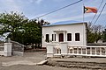
Office of the assistant secretary of the administrator of Liquiçá (born 1936). Today the administration building of the Ministry of Transport

Primary school Escola Primária

Former municipal school Escola Municipal

Parish Church of Sao Joao de Brito

Parish Church of Sao Joao de Brito

Former Hotel Tokodede
.jpg)
.jpg)


politics
In the elections of 2004/2005 was Oscar da Silva elected Chefe de Suco and in 2009 re-elected.
economy
Dato residents use the sea for fishing. To the east of Liquiçá, salt is obtained through the evaporation of sea water. A hotel has been established on Black Rock.

Salt production east of Liquiçá
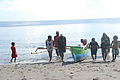
In Camalehohoru, fishermen bring their boats ashore with their catch

The fish are sorted according to their size

The fish are laid out to dry in the sun

Water is brought in to eviscerate the fish.

Packaged dried fish

The store for selling dried fish was built with Australian help

Black Rock Resort and Restaurant at Leopa


Web links
- Results of the 2010 census for the Suco Dato ( tetum ; PDF; 8.3 MB)
- Results of the 2015 census for the Suco Dato (tetum; PDF)
- Seeds of Life: Suco information sheets Liquiçá (tetum)
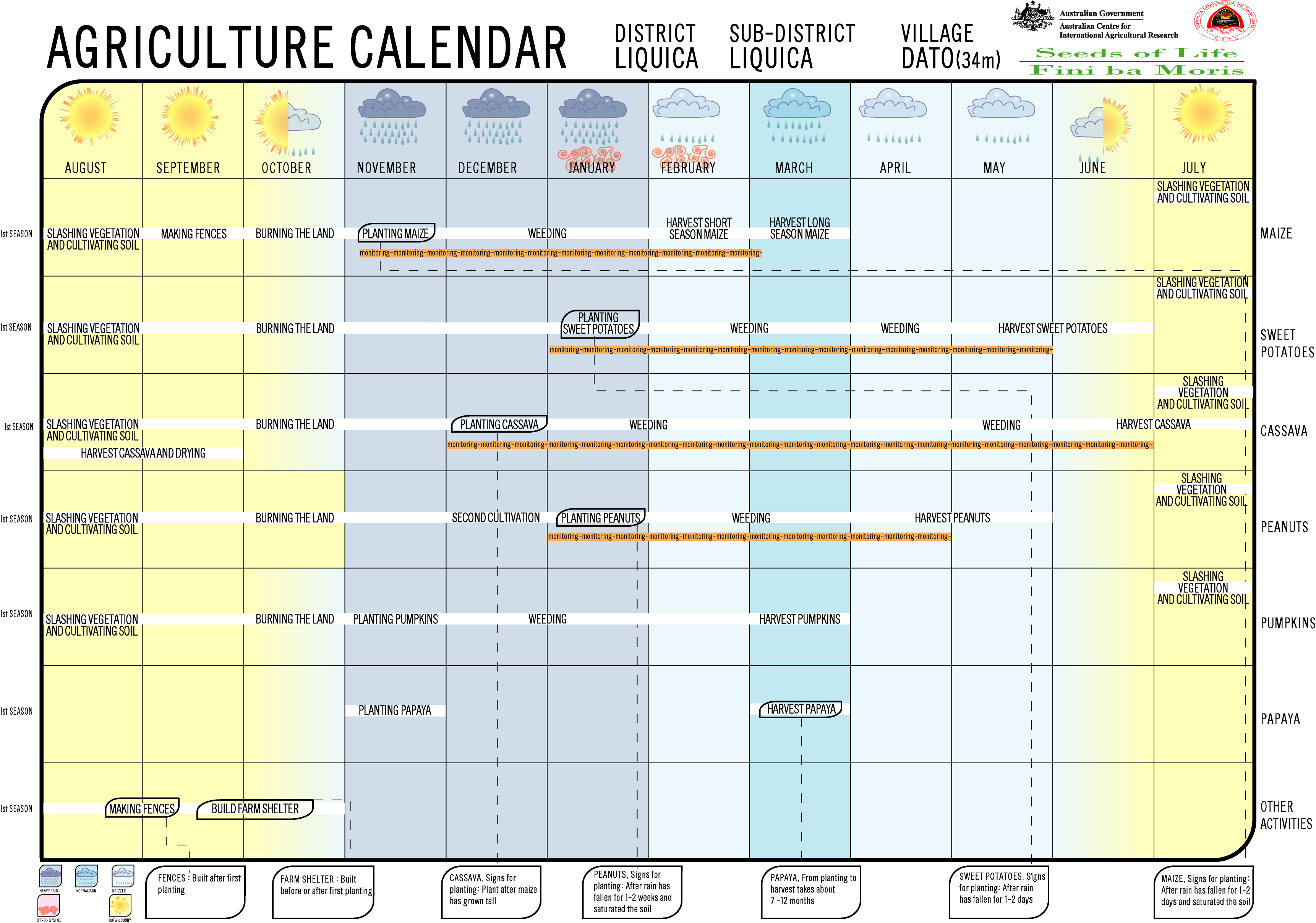
- Seeds of Life: Agriculture Calendar (English)
Individual evidence
- ↑ a b c d Direcção-Geral de Estatística : Results of the 2015 census , accessed on November 23, 2016.
- ↑ a b List of polling stations for the parliamentary elections in East Timor 2007 (PDF; 118 kB)
- ↑ Fallingrain.com: Directory of Cities, Towns, and Regions in East Timor
- ↑ Results of the 2010 census for the Suco Dato ( tetum ; PDF; 8.3 MB)
- ↑ Direcção Nacional de Estatística: Population Distribution by Administrative Areas Volume 2 English ( Memento from January 5, 2017 in the Internet Archive ) (Census 2010; PDF; 22.6 MB)
- ^ Timor-Leste GIS-Portal ( Memento from June 30, 2007 in the Internet Archive )
- ↑ UNMIT: Timor-Leste District Atlas version 02, August 2008 ( Memento of December 3, 2011 in the Internet Archive ) (PDF; 486 kB)
- ↑ Jornal da Républica with the Diploma Ministerial n. 199/09 ( Memento of February 3, 2010 in the Internet Archive ) (Portuguese; PDF; 323 kB)
- ↑ Geoffrey C. Gunn: History of Timor ( Memento of the original from March 24, 2009 in the Internet Archive ) Info: The archive link was inserted automatically and has not yet been checked. Please check the original and archive link according to the instructions and then remove this notice. - Lisbon Technical University (PDF; 805 kB)
- ↑ "Chapter 7.3 Forced Displacement and Famine" ( Memento of November 28, 2015 in the Internet Archive ) (PDF; 1.3 MB) from the "Chega!" Report of the CAVR (English)
- ↑ Relief Web, January 7, 2008, Timor-Leste: Humanitarian update, December 21 - January 7, 2008
- ↑ a b c d e Information board in front of the building (in Tetum, Portuguese, English)
- ↑ Secretariado Técnico de Administração Eleitoral STAE: Eleições para Liderança Comunitária 2004/2005 - Resultados ( Memento of August 4, 2010 in the Internet Archive )
- ↑ Secretariado Técnico de Administração Eleitoral STAE: Eleições para Liderança Comunitária 2009 - Resultados ( Memento of August 4, 2010 in the Internet Archive )
![]() Map with all coordinates: OSM | WikiMap
Map with all coordinates: OSM | WikiMap
The administrative borders within East Timor changed in 2015. This article must therefore be checked and updated if necessary. See New Administrative Boundaries .