
Dirmsteiner Almond Path

The Mandelpfad is a vineyard of Dirmstein , an ancient Palatine winemaker community in northeastern Leiningerland ( Rheinland-Pfalz ). After the reorganization of the vineyards in the village in the second half of the 20th century, it represents the second largest single location with 152.5 hectares. Both white and red grape varieties, predominantly Riesling , gray and white Burgundy (white) or Dornfelder and are grown Pinot Noir (red).
geography
location
The almond path extends to heights between 164 and 104 m above sea level. NHN west and north-west of the historic upper village. It borders in the south on the district of Laumersheim , in the west on the district of Obersülzen , in the north on the district of Offstein . Its eastern border is formed by the state road 455 (Offstein – Dirmstein), beyond which the largest single location Dirmsteiner Herrgottsacker begins, as well as the residential development of Dirmstein. As a special feature, a vineyard belonging to the Almond Path is located in the middle of the small, isolated Dirmsteiner Jesuitenhofgarten .
The Floßbach , a left tributary of the Eckbach , which in turn touches the vineyards in the extreme south, flows through the northern area of the Almond Path from west to east .
Climate and soil
The sunny and rain-free climate of the Leiningerland also favors the production of high-quality plants in Dirmstein . The Almond Trail is located on sheltered and slightly sloping hills, on the east and south-east slopes of the Wörschberg and on the east slope of the Goldberg . The soil is dry and consists partly of sand , partly of loess , in the lower areas to the left of the Eckbach and on both sides of the Floßbach also from deposits of limestone marl . All components ensure rapid heating in the sunshine. The terrain is at a favorable angle to the course of the sun, which increases the intensity of the radiation and extends the time during which the grapes are exposed to the sun during the day and can form sugar . The slope of the slope also means that on frosty spring nights, cold air masses flow off in small areas to the residential areas and the vines usually do not freeze .
Natural monuments
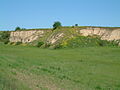
Three of Dirmstein's natural monuments are located within the Almond Trail . From south to north / east it is:
- the loess walls west of Dirmstein , into which the state road 453 (Dirmstein – Obersülzen) is cut
- the Wörschberger Hohl, also characterized by loess walls
- the Chorbrünnel , a sulfur spring set in stone in the 16th century
Wörschberger Hohl and Chorbrünnel are stops on the Chorbrünnel circular route .
Loess walls west of Dirmstein

Loess walls of the Wörschberger Hohl

Chorbrünnel


history
Wine has been grown in the Vorderpfalz since Roman times . In Dirmstein, viticulture was first mentioned in a document in 1141.
Shortly before the end of the Second World War , the Englishman Cyril William Sibley survived the shooting down and crash of his aircraft as a crew member on the slope of the Almond Path south of today's L 453, but was subsequently the victim of a so-called air murder by Adolf Wolfert , a local NSDAP functionary .
There used to be numerous vineyards in Dirmstein, most of which were not very extensive. Soon after the Second World War, they were combined into three individual layers, from west to east Almond Path (152.5 hectares), Jesuitenhofgarten (5.5 hectares) and Herrgottsacker (155.2 hectares). All of them belong to the black earth area .
Web links
- Location and outline of the Dirmstein Almond Trail at weinlagen-info.de
- Map of the three vineyards of Dirmstein at weinlagen-info.de
Individual evidence
- ↑ a b vineyards online. Chamber of Agriculture Rhineland-Palatinate, accessed on May 29, 2015 (search: single site Mandelpfad (Dirmstein)).
- ↑ Map service of the landscape information system of the Rhineland-Palatinate nature conservation administration (LANIS map) ( notes )
- ↑ The names Oberdorf and Niederdorf for the two settlement centers of the municipality are derived from the location above and below at the Eckbach , which flows through Dirmstein from west to east.
- ↑ Rudolf Kraft : Das Reichsgut in Wormsgau (= sources and research on Hessian history . Volume 16 ). Hessischer Staatsverlag, Darmstadt 1934, p. 259 .
Coordinates: 49 ° 34 ′ 5 ″ N , 8 ° 14 ′ 2 ″ E