Chota district
| Chota district | ||
|---|---|---|
 The district of Chota is located in the central east of the province of Chota |
||
| Symbols | ||
|
||
| Basic data | ||
| Country | Peru | |
| region | Cajamarca | |
| province | Chota | |
| Seat | Chota | |
| surface | 261.8 km² | |
| Residents | 47,279 (2017) | |
| density | 181 inhabitants per km² | |
| ISO 3166-2 | PE-CAJ | |
| Website | munichota.gob.pe (Spanish) | |
| politics | ||
| Alcalde Provincial | Werner Cabrera Campos (2019-2022) |
|
| Political party | Acción Popular | |
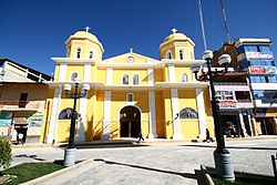
| Chota Cathedral | ||
Coordinates: 6 ° 34 ′ S , 78 ° 39 ′ W
The district of Chota is located in the province of Chota in the Cajamarca region in northwestern Peru . The district has an area of 261.75 km². The 2017 census counted 47,279 inhabitants. In 1993 the population was 43,913, in 2007 45,958. The district administration is seated in the provincial capital Chota at an altitude of 2388 m with 22,159 inhabitants (as of 2017).
Geographical location
The district of Chota is located in the Peruvian Western Cordillera in the central east of the province of Chota. The area is drained to the northwest via the Río Chotano , the right source river of the Río Chamaya .
The district of Chota borders in the west on the district Lajas , in the northwest on the districts Cutervo ( province Cutervo ) and Chiguirip , in the northeast on the district Conchán , in the east on the district Chalamarca , in the southeast on the districts Bambamarca and Hualgayoc and in the southwest the district of Chugur (the last three districts are in the province of Hualgayoc ).
Individual evidence
- ↑ a b Chota, Province in Cajamarca Region . www.citypopulation.de. Retrieved April 10, 2020.

