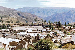
Corculla district
| Corculla district | |
|---|---|
 The Corculla district is located in the southeast of the Páucar del Sara Sara province (marked in red) |
|
| Basic data | |
| Country | Peru |
| region | Ayacucho |
| province | Páucar del Sara Sara |
| Seat | Corculla |
| surface | 101 km² |
| Residents | 469 (2017) |
| density | 4.6 inhabitants per km² |
| founding | July 24, 1952 |
| ISO 3166-2 | PE-AYA |
| politics | |
| Alcalde District | Percy Conberty Mendoza Acapana (2019-2022) |
| Political party | Movimiento Regional Gana Ayacucho |
Coordinates: 15 ° 16 ′ S , 73 ° 12 ′ W
The Corculla district is located in the Páucar del Sara Sara province in the Ayacucho region in south-central Peru . The district was established on July 24, 1952. It has an area of 101 km². The 2017 census counted 469 inhabitants. In 1993 the population was 753, in 2007 it was 566. The district administration is based in the 3470 m high village of Corculla with 311 inhabitants (as of 2017). Corculla is just 16 km east of the provincial capital Pausa .
Geographical location
The Corculla district is located in the Cordillera Volcánica in the southeast of the Páucar del Sara Sara province. It is bounded in the northwest and in the west by the Río Oyolo and Río Marán. The Río Ccachi crosses the district centrally in a westerly direction.
The Corculla district is bordered to the west by the district Pausa , in the northwest on the district Colta , to the north by the district of San José de Ushua , on the east by the district Quechualla , in the extreme southeast of the district Tauria and the south by the district Sayla ( the last three districts mentioned belong to the province of La Unión ).
Localities
In addition to the main town, there are the following larger towns in the district:
- Huayrana
- Pampachacra
Web links
- Peru: Ayacucho region (provinces and districts) at www.citypopulation.de
- INEI Perú
