Palca District (Lampa)
| Palca district | |
|---|---|
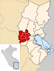
 The district of Palca is north-central in the province of Lampa (marked in red) |
|
| Basic data | |
| Country | Peru |
| region | Puno |
| province | Lampa |
| Seat | Palca |
| surface | 495 km² |
| Residents | 1930 (2017) |
| density | 3.9 inhabitants per km² |
| founding | October 25, 1901 |
| ISO 3166-2 | PE-PUN |
| politics | |
| Alcalde District | Humberto Salazar Mamani (2019-2022) |
| Political party | Poder Democrático Regional |
Coordinates: 15 ° 14 ′ S , 70 ° 36 ′ W
The Palca district is located in the Lampa province in the Puno region in southern Peru . The district was founded on October 25, 1901. It has an area of 495 km². The 2017 census counted 1930 inhabitants. In 1993 the population was 3081, in 2007 3027. The seat of the district administration is the 4020 m high village of Palca with 712 inhabitants (as of 2017). Palca is located 28 km west-northwest of the provincial capital Lampa .
Geographical location
The district of Palca is located in the Andean highlands north-central in the province of Lampa. The longitudinal extension in east-west direction is almost 33 km, the maximum width is 25 km. Along the southern district boundary runs a mountain range with the peaks Quilca, Jatun Pasto, Huayquera, San Luis, Milna Punta and San Carlos. The Río Lampa (also Río Palca) drains the area to the east.
The Palca district borders in the west on the Ocuviri district , in the north on the Vilavila district , in the northeast on the Ayaviri ( Melgar province ) and Pucará districts , in the east on the Lampa district and in the south and southwest on the Paratía district .
Web links
- Peru: Region Puno (provinces and districts) at www.citypopulation.de
- INEI Perú