Providencia District
| Providencia District | |
|---|---|
| Basic data | |
| Country | Peru |
| region | Amazon |
| province | Luya |
| Seat | Providencia |
| surface | 71.2 km² |
| Residents | 1316 (2017) |
| density | 18 inhabitants per km² |
| founding | June 18, 1987 |
| ISO 3166-2 | PE-AMA |
| politics | |
| Alcalde District | Wild Puerta Vásquez (2019-2022) |
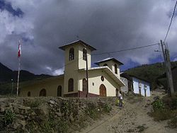
| The Church of Providencia | |
Coordinates: 6 ° 17 ′ 52 " S , 78 ° 14 ′ 24" W
The Providencia district is one of the 23 Peruvian districts that the luya province in the region Amazon form. The district has an area of 71.22 km². The population was 1316 at the 2017 census. The district administration is located in the village of Providencia.
Providencia is located in a very hot area, on the slope above the Marañón river .
There are numerous ruins of the Chachapoya people in the Providencia district . To get to Providencia you have to drive to Ocallí and walk from there, Providencia itself has no access to the road.
The village festival in Providencia takes place on July 17th . The Providencia district is part of the Ocallí parish.
Most of the district's residents make a living from growing coffee and coca .
Geographical location
In the north, the Providencia district borders on the Pisuquía district , the Camporredondo district and the Ocallí district , in the east on the Ocumal district and in the southwest on the Choropampa district .
Villages and homesteads in the Providencia district
- Providencia
- Huingo
- Gramalote
- San Antonio
- Cruz Lomas
- Lima Yacu
- El Carmelo
- Nuevo Chota
- Hondul
- Las Palmas
- San Pedro
- La Playa Jumith
- Trapichepampa
- Chirapa
- Huidac
- La Libertad
Web links
- Peru: Amazonas region (provinces and districts) at www.citypopulation.de
