San Pablo District (Canchis)
| San Pablo District | |
|---|---|
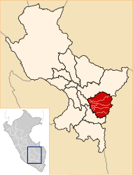
 The district of San Pablo is south-central in the province of Canchis (marked in red) |
|
| Basic data | |
| Country | Peru |
| region | Cusco |
| province | Canchis |
| Seat | San Pablo |
| surface | 523 km² |
| Residents | 4582 (2017) |
| density | 8.8 inhabitants per km² |
| founding | October 12, 1897 |
| ISO 3166-2 | PE-CUS |
| politics | |
| Alcalde District | Jose Quispe Puma (2019-2022) |
Coordinates: 14 ° 12 ′ S , 71 ° 19 ′ W
The district of San Pablo is located in the Canchis Province of the Cusco region in south-central Peru . The district was founded on October 12, 1897. It has an area of 523 km². At the 2017 census, 4582 people lived in the district. In 1993 the population was 6004, in 2007 it was 4979. The district administration is located in the 3486 m high town of San Pablo with 1838 inhabitants (as of 2017). San Pablo is located on the north bank of the Río Vilcanota (upper reaches of the Río Urubamba) 12 km northwest of the provincial capital Sicuani .
Geographical location
The district of San Pablo is located in the Andean highlands south-central in the province of Canchis. The Río Vilcanota crosses the far west of the district in a north-westerly direction. The Río Salcca flows through the eastern and central parts of the district in a westerly direction.
The district of San Pablo borders in the extreme southwest with the district Yanaoca ( province Canas ), in the northwest with the districts Tinta , San Pedro and Combapata , in the north with the district Checacupe , in the east with the districts Corani ( province Carabaya ) and Nuñoa ( province Melgar ) and in the south to the Sicuani district .
Localities
In addition to the main town, the district has the following larger towns:
- Chara (271 inhabitants)
- Santa Barbara (234 inhabitants)
Web links
- Peru: Region Cusco (provinces and districts) at www.citypopulation.de
- INEI Perú