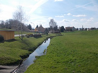
Eckartsbach
| Eckartsbach | ||
|
The Eckartsbach in Eckartsberg |
||
| Data | ||
| Water code | DE : 674154 | |
| location | Saxony | |
| River system | Or | |
| Drain over | Lusatian Neisse → Oder → Baltic Sea | |
| source | in Oberseifersdorf 50 ° 57 '1 " N , 14 ° 47' 20" E |
|
| Source height | 342 m above sea level NN | |
| muzzle | south of the Weinau in Zittau in the Lusatian Neisse Coordinates: 50 ° 53 ′ 49 ″ N , 14 ° 50 ′ 14 ″ E 50 ° 53 ′ 49 ″ N , 14 ° 50 ′ 14 ″ E |
|
| Mouth height | 218 m above sea level NN | |
| Height difference | 124 m | |
| Bottom slope | approx. 12 ‰ | |
| length | approx. 10 km | |
| Left tributaries | Feldbach, Ochsengraben | |
| Right tributaries | Krebsbach, Döringwasser, Riesten or Hasenbergwasser, Bergstraßenwasser | |
| Small towns | Zittau | |
| Communities | Mittelherwigsdorf | |
The Eckartsbach is a left tributary of the Lusatian Neisse with a length of approx. 10 km in the town of Zittau in the east Saxon district of Görlitz .
description
The stream rises on the north-western outskirts of Oberseifersdorf on the edge of the Kohlige in a depression south of the Steinberg (373.5 m above sea level) or northeast of the Pferdeberg and is crossed after approx. 50 m by the federal road 178 , which forms the watershed at Sonnenhübel to the Erlichbach . The village of Oberseifersdorf extends along its upper course, which initially leads to the south-east and then from the Schanzberg to the south through a gentle hollow.
Below the confluence of the Krebsbach, the Eckartsbach flows under the new B 178 at the Lehdegarten farmstead to Eckartsberg . From the Schleekretscham down, the brook has created a deep valley east of the Höllberg, in which the Schleemühle was built in 1676. Basalt gravel was previously extracted in several quarries on this section .
At the height of the Hasenberggüter the Eckartsbach flows into the area of the city of Zittau; there it takes a south-easterly direction and flows around the city to the north and east, bridging it by the Zittau – Görlitz railway line. On the left side of the terrace above the valley, the village of Eckartsberg stretches out, with the Eckartsbach flowing alternately on the Zittauer and Eckartsberger Flur near the boundary of the district. Towards Zittau the terrain level rises only slightly, the wide and fertile floodplain was previously used by the numerous Zittau gardeners for growing vegetables. Since the end of the 19th century, the town has been expanding towards Eckartsbachaue, and a large part of the former gardening area in Zittau North and Zittau East has since given way to residential development.
At the Zittau crematorium, the stream is crossed by federal road 99 . In its last section, the straightened Eckartsbach flows west and south of the Weinau Park through Zittau. Before the Weinau marshland was drained, the stream at the foot of the vineyard near Neumühle fed the eight wine ponds (Komturteich, Aueteich, Lehmanns pond, Oberer, Mittlerer and Nieder Bergteich, Lessigteich, Mühlteich). The stream flows north of the Chopinstrasse bridge on the border with Poland into the Lusatian Neisse .
Flood
On May 27, 1984, the stream in Oberseifersdorf flooded almost 30 houses after a downpour.
The lower Eckartsbach in Zittau is affected by backwater when the Neisse floods occur. Even with a medium high water level of HQ 20, extensive flooding of the adjacent built-up areas occurs. On August 7th and 8th, 2010, sustained heavy rainfall led to a century flood of the Neisse, which prevented the Eckartsbach from flowing away and flooded the entire Weinau Park, including the zoo and the Weinau Park Stadium . Within a short time the water in the park accumulated up to a height of 1.5 m, sometimes up to 2.5 m, and turned it into a large lake.
literature
- The south-eastern Upper Lusatia with Zittau and the Zittau Mountains (= values of the German homeland . Volume 16). 1st edition. Akademie Verlag, Berlin 1970
Individual evidence
- ^ Miles sheet Zittau
- ↑ Archive link ( Memento of the original from February 13, 2016 in the Internet Archive ) Info: The archive link was inserted automatically and has not yet been checked. Please check the original and archive link according to the instructions and then remove this notice.
- ↑ https://www.umwelt.sachsen.de/umwelt/wasser/download/39-1_01_Zittau.pdf
- ↑ http://tierpark-zittau.de/ueber-uns/flut-2010/
