Elbe map
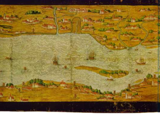
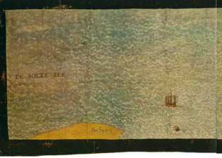
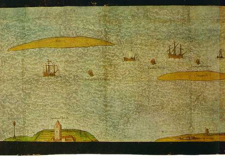
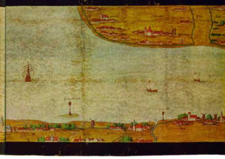
The Elbe map by Melchior Lorichs is a one meter high and twelve meter long view of the Lower Elbe from Geesthacht to the North Sea from 1568, created on behalf of the City Council of Hamburg . The card is in the Hamburg State Archives . A reproduction is on display in the Museum of Hamburg History .
background
The background was a dispute between the city of Hamburg and the Duchy of Braunschweig and Lüneburg over stacking rights on the Elbe , which Hamburg claimed for itself. In the 16th century the cities complained Harburg , Stade , Buxtehude and Lueneburg in the Supreme Court on their right to free navigation, claiming that the 1482 by Emperor Frederick III. The privilege granted to Hamburg only applies to the Norderelbe from the Bunthausspitze to the Mühlenberger Loch , while the Süderelbe is the main river in the Elbe delta to which Hamburg cannot expand its sphere of influence.
The Hamburgers then commissioned the painter and cartographer Lorichs to draw up a map of the course of the Elbe, which was presented to the court in 1568. This showed, on the one hand, that the Elbe is a uniform river, the main water of which flows over the Norderelbe, and on the other hand, through the precise drawing of beacons and fairway markings, that the city of Hamburg is primarily responsible for securing the river. Lorichs received 580 marks for this work, which was roughly the annual salary of the then senior councilor . On April 16, 1619 the judgment was issued on the basis of this Elbe map, which recognized the Hamburg privileges for the entire area of the Lower Elbe, but rejected the extension of the stacking right to the southern Elbe. Hamburg immediately accepted the judgment, Denmark , which had added further points to the proceedings, only waived the revision in the Gottorp Treaty of 1768 and thus made the judgment legally binding.
description
The map measures 12.15 meters by 1.09 meters including the black border. It consists of 44 folded folio sheets measuring approximately 56.5: 44.5 cm. These sheets are glued on top of each other in two rows and another row 11 cm high is added at the top. The leaves are laid on canvas with a vertical overlap of 2 to 3 cm and a horizontal one of 6 cm. It was presented to the court hearing in December 1567, presumably uncoloured, and only colored in a later operation and completed on March 1, 1568.
presentation
Although the North Elbe is unrealistic in size compared to the South Elbe, the overall representation of the map with its other accuracy and richness of detail is considered to be one of the most informative documents on the topography of the Lower Elbe in the 16th century. Above all, the conditions in the Hamburg area are, with a few exceptions, clearly recorded. They make up about a third of the map.
In the eastern part of the map, in the representation of the Vierlande and Marschlande, the already completed dikes of the Gose Elbe and Dove Elbe as well as the construction of the lock ditch between Bille and Dove Elbe south of Bergedorf can be seen. Upstream of the city of Hamburg are the Grasbrook , which is not yet divided into the large and the small Grasbrook , and Grandeswerder . There are a number of river islands between the Norder- and Süderelbe, the former Gorieswerder , which was divided by several storm surges. The main part was dammed together around 1700, this is where the later Hamburg district of Wilhelmsburg emerged . The confluence of the Süderelbe is shown in the western part of the archipelago , with various branches of the river, including the Köhlbrand , and the islands of Finkenwerder and Altenwerder located in it .
The other two thirds of the map mainly show shipping traffic and the Hamburg buoys and beacons regulating the route . The numerous neighboring towns such as Stade or Brunsbüttel are drawn relatively small next to the two Hamburg locations Ritzebüttel and Neuwerk in the mouth of the Elbe.
Drawing by Eugen Schuback
Eugen W. Schuback made a drawing in 1843. It is reduced to about a quarter. Towards the sea it ends with Neuwerk and does not depict Scharhörn. It is also an eighth shorter. In addition, the map contains a replica of a Ritzebuettel map by Melchior Lorck from 1595, reduced to a quarter, which was lost in the fire of 1842.
See also
literature
- Ernst Baasch : The battle of the House of Braunschweig-Lüneburg with Hamburg for the Elbe from the 16th to 18th centuries (= sources and representations on the history of Lower Saxony. Vol. 21, ISSN 0930-908X ). Hahn, Hanover / Leipzig 1905, available in open library .
- Jörgen Bracker : Hamburg's port facilities in the 16th century. In: Jörgen Bracker: Hamburg. From the beginning to the present. Turning marks in a city's history. 2nd, revised edition. Kabel, Hamburg 1988, ISBN 3-8225-0043-7 , pp. 83-93.
- Johann Martin Lappenberg : Melchior Lorich's Elbe map from 1568. Meissner, Hamburg 1847, digitized .
- Ernst Christian Schütt: Elbe map as evidence. In: Chronicle Hamburg. 2nd, updated edition. Chronik-Verlag, Gütersloh 1997, ISBN 3-577-14443-2 , pp. 94-95.
Web links
- December 3, 1567: The secret of this Elbe map in Hamburg. In: mopo.de. Retrieved April 28, 2019 .
- Hamburg's claim to the Elbe. In: hamburg.de. Retrieved April 28, 2019 .


