Falerone
| Falerone | ||
|---|---|---|

|
|
|
| Country | Italy | |
| region | Brands | |
| province | Fermo (FM) | |
| Coordinates | 43 ° 6 ' N , 13 ° 28' E | |
| height | 433 m slm | |
| surface | 24.52 km² | |
| Residents | 3,262 (Dec. 31, 2019) | |
| Population density | 133 inhabitants / km² | |
| Post Code | 63837 | |
| prefix | 0734 | |
| ISTAT number | 109005 | |
| Popular name | Faleronesi | |
| Patron saint | Fortunatus of Todi | |
| Website | Falerone | |
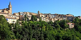
 Panorama of Falerone |
||
Falerone (in the local dialect: Falleró or Faleró ) is an Italian commune ( comune ) with 3262 inhabitants (as of December 31, 2019) in the province of Fermo in Marche .
geography
The municipality is located about 28 kilometers west-southwest of Fermo , about 21 kilometers south of Macerata and about 33 kilometers north-northwest of Ascoli Piceno . Falerone borders directly on the province of Macerata . The Tenna , into which the Salino flows here, flows south of the municipality .
history
In ancient times the place of Falerio was of some importance. It takes its name from the Latin toponym Mons Falarinus , at whose foot Falerone was founded. It is probably a colony founded by Augustus after the Battle of Actium for the returning legionaries.
Falerone has been a titular bishopric since 1969 .
traffic
The station on the Porto San Giorgio - Amandola line was closed like this one in 1956.
Parish partnership
Falerone and the neighboring municipality of Montappone have a partnership with the French municipality of Cormeilles in the Eure department .
Web links
Individual evidence
- ↑ Statistiche demografiche ISTAT. Monthly population statistics of the Istituto Nazionale di Statistica , as of December 31 of 2019.

