Fatu Hiva
| Fatu Hiva | ||
|---|---|---|
| Fatu Hiva, west coast | ||
| Waters | Pacific Ocean | |
| Archipelago | Marquesas | |
| Geographical location | 10 ° 30 ′ S , 138 ° 40 ′ W | |
|
|
||
| length | 16 km | |
| width | 9 km | |
| surface | 84 km² | |
| Highest elevation | Mont Touaouoho 1125 m |
|
| Residents | 636 (2007) 7.6 inhabitants / km² |
|
| main place | Omoa | |
| Map of Fatu Hiva | ||
Fatu Hiva (also Fatuhiva , Fatu Iva , old name: Magdalena ) is an inhabited island in the Pacific Ocean that geographically belongs to the southern group of the Marquesas Islands.
geography
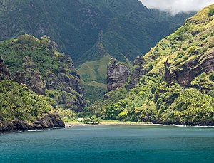
The island is - although it does not offer the "typical" South Sea image with palm-covered beaches - the landscape is probably the most spectacular of the archipelago . Steep basalt cones densely overgrown with tropical rainforest characterize the landscape. The highest point is the 1125 m high Mont Touaouoho. Rugged rock faces with narrow crevices and deep gorges rise directly from the sea. There is no coastal plain, except for a few places the coast is inaccessible. Small beaches of black gravel or sand have formed at some valley cuts. The strong surf hits the island unprotected as no fringing reef could form.
geology
Geologically, Fatu Hiva belongs to the "Marquesas linear volcanic chain", which was formed from a hotspot on the Pacific plate and moves at a speed of 103 to 118 mm per year in the direction of the WNW. The island's basaltic rocks are 1.3 to 3.7 million years old.
climate
Fatu Hiva is located in the tropical belt of the earth. The climate varies from hot and humid in the coastal areas to cool and humid in the mountain regions with frequent and abundant rainfall on the windward south-east side of the island. The clouds carried along by the trade winds accumulate on the high peaks and rain down. The daytime temperatures rarely drop below 25 ° C in the coastal area, but the nights can occasionally be uncomfortably cool.
flora
The landscape around the settlements in the coastal area and up the valleys has been extensively remodeled for human food production, so little of the original vegetation has remained. The massive interventions, already in historical times, probably led to the extinction of an unknown number of endemic and indigenous plants in the lower and middle areas of the island. Today's residents cultivate breadfruit , coconut , yams , taro , sweet potatoes , bananas and other tropical fruits for their own needs .
The higher areas of the mountainous island are covered by natural mountain rainforest and cloud forest interspersed with tree ferns . About 600m dominate metrosideros (Metrosideros- and Weinmannia woods are). But even these inaccessible areas are threatened, because wild goats are a heavy burden on the flora. The peaks of the peaks and extensive areas in the lee of the mountains are arid .
The mountain rainforest is still home to some endemic plants, including Pelea fatuhivensis (syn. Melicope fatuhivensis ), which belongs to the rue family , but which may have already died out. A systematic study of the flora with the support of the Smithsonian Institution in 1988 revealed the number of 175 indigenous , 21 endemic and 136 anthropochoric plants.
fauna
The rich flora contrasts with a relatively species-poor fauna. It is limited to land and sea birds, insects, butterflies, spiders and a single species of bats. The Fatuhiva monarch ( Pomarea whitneyi ) is endemic . Since Fatu Hiva is considered to be free from rats, efforts are being made to relocate endangered land bird species from other islands in the Marquesas. This has been achieved, for example, with the Ultramarine Loris ( Vini ultramarina ) from the Loris family .
history
→ Main article: History of the Marquesas
Fatu Hiva was the first island of the Marquesas to be landed on July 21, 1595 by a European, Alvaro Mendana de Neira . He called her Santa Magdalena . The island was the last of the Marquesas to become a French colony (1880).
Little is known about the culture of Fatu Hiva before the European influence, as it was significantly affected with the arrival of the missionaries. In the great valleys, as in the rest of the Marquesas Islands, stratified tribal societies were formed . Karl von den Steinen describes nine tribes in 1897 that inhabited the valleys Hanamoohe, Hanateone, Hanahouuna (Hanaouua? Haahouna?), Ouia, Hanavave and Omoa. In the Hanavave valley, four tribes of the stones are known. Systematic archaeological excavations have so far not taken place. The American anthropologist Ralph Linton carried out surface studies on behalf of the Bishop Museum, Honolulu in the years 1920–1921. The findings are less numerous than on the other islands of the Marquesas and indicate less extensive construction activity. Linton found the remains of several tohua (ceremonial and power-political centers) with house platforms ( paepae ) and small me'ae in the Omoa Valley . This suggested to Linton that several tribes used to live there. During his brief visit to the Hanavave Valley, Linton could only find small remains of a tohua and a stone ceremonial platform . In contrast to the other islands of the Marquesas, the dead on Fatu Hiva were occasionally mummified (smoked) and often buried in the houses. Thor Heyerdahl discovered petroglyphs during his stay in 1937, which "were carved on large stone slabs in the forest and represented motifs unknown in other areas of Polynesia." The bas-relief of a fish was about 2 meters long.
Colossal stone statues were not found on the island, but some roughly made small stone sculptures have been preserved. This does not mean that there were no outstanding works of art on Fatu Hiva in prehistoric times. The island was better known for tattooists and wood carvers, whose ephemeral works have barely survived the ages.
Politics and administration
Politically, the island belongs to the French Overseas Zealand ( Pays d'outre-mer - POM) French Polynesia and is therefore affiliated to the EU. It is administered by a subdivision ( Subdivision administrative des Îles Marquises ) of the High Commission of French Polynesia ( Haut-commissariat de la République en Polynésie française ) based in Papeete . Fatu Hiva forms an independent municipality ( Commune de Fatu Hiva ) with 636 inhabitants (2012), the population density is around 7 people / km².
The official language is French. The currency is (still) the CFP franc, which is linked to the euro . The main town and administrative center is the village of Omoa on the west coast with around 250 inhabitants.
Infrastructure
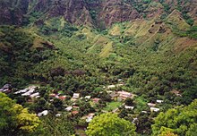
The inhabitants of the 84 km² island live mainly in the villages of Omoa and Hanavave on the west coast, which are connected by a dirt road over the mountains. The larger of the villages is Omoa, with a Catholic church, a preschool and elementary school ( école maternelle et primaire ), a small shop, post office and satellite telephone. Fatu Hiva has no paved roads between the two places, no docks for large ships and no airfield. Safe landing on the inaccessible coast is only possible in the two bays on the west coast, where the villages are located.
economy
The islanders live mainly from subsistence farming . Selling monoi oil , carvings and painted tapa bark fibers to the rare cruise tourists and circumnavigators brings some money.
Fatu Hiva has been known for the high quality and craftsmanship of the tapa work since historical times. Today they are still produced in the traditional way, mainly monochrome . However, chemical colors are now used and no longer the soot of the light nut .
A local variant of Monoi oil called Umu Hei Monoi is produced on the island . It contains fragrances of sandalwood , jasmine , ginger , ylang-ylang and other herbs and spices.
The Tourism plays a minor role economically. There is no corresponding infrastructure with a hotel, restaurants, bank and organized sightseeing tours. Visitors are dependent on modestly furnished private quarters and a high degree of initiative. Fatu Hiva does not have a beach. The island is rarely visited by cruise ships.
Attractions
- The three-hour walk between the two villages is strenuous because of the heat, the steep climbs and the omnipresent mosquitoes, but it is rewarding and offers spectacular views over the island and the ocean. It also leads past an impressive waterfall.
- In the house of the Grélet family in Omoa, who originally came from Switzerland, there is a small private collection of interesting art, cult and everyday objects that are gladly shown to the rare visitors. The stock includes carefully cut stone blades made of black basalt, artfully decorated, historical weapons, carvings, traditional tapas and small stone figures. The extensive collection of masterfully ornamented bowls made from rare woods is unique. The vessels, called koka'a , with a diameter of up to one meter, were used to serve popoi , a porridge made from breadfruit, which was once the island's main food and is still an important part of meals today.
Others
- The island was best known through the book of the same name by Thor Heyerdahl , who in 1937 spent around eight months on the island with his first wife Liv in a self-chosen robinsonade . The couple first lived near the west coast in the Omoa Valley, later on the east coast in Ouia, which is now uninhabited; In 1937 there was also an old man named Tei Tetua, who, according to his own statement, was the son of one of the last real cannibals, who lived there with his twelve-year-old adopted daughter.
- A first book about the stay was published in 1938 by Gyldendal , Oslo, sold poorly despite the best reviews and was never translated, probably because of the war. Heyerdahl's well-known book Fatu Hiva was later rewritten, according to the author's note: After the success of his book about the Kon-Tiki company, his first work was out of date.
- In Jack London's short story collection "A Son of the Sun" , the island appears under the name Fitu-Iva. In the story “Feathers of the Sun”, Fitu-Iva comes under the influence of a cunning deceiver from the Solomon Islands who, with the tolerance of the always drunk chief, introduces paper money and exchanges all valuables for self-made means of payment. When the fraud is discovered, he is beaten with a dead pig, a particularly dishonorable punishment, and banned from the island.
Web links
Individual evidence
- ↑ Carlo Doglioni and Marco Cuffaro: The hotspot reference frame and the westward drift of the lithosphere . Rome 2005.
- ↑ Valérie Clouard & Alain Bonneville: Ages of seamounts, islands and plateaus on the Pacific plate . In: Foulger, GR, Natland, JH, Presnall, DC, and Anderson, DL, (eds.): Plates, plumes, and paradigms . Geological Society of America Special Paper , No. 388, pp. 71-90.
- ^ Jacques Florence and David H. Lorence: Introduction to the Flora and Vegetation of the Marquesas Islands . In: Allertonia , Vol. 7, February 1997, pp. 226-237, ISSN 0735-8032
- ↑ Ralph Linton : Archeology of the Marqueas Islands , Bernice P. Bishop Bulletin No. 23, Honolulu 1925, pp. 181-185
- ^ A b Thor Heyerdahl: Fatu Hiva - Back to Nature , Bertelsmann-Verlag, Munich-Gütersloh-Vienna; New edition: Goldmann-Verlag. Munich 1996, ISBN 3-442-08943-3
- ^ Institut Statistique de Polynésie Française (ISPF) - Recensement de la population 2012
- ↑ Heyerdahl, Fatu Hiva p. 19.
- ↑ Jack London: A son of the sun and other South Sea stories (original title: A Son of the Sun ), Universitas-Verlag, Berlin 1926


