
Fort St Lucian

The Fort St Lucian , and St Lucian Tower or Fort de Rohan , is one of during the reign Hospitaller Order of 1610 and was built to 1611 significantly expanded in the period of British colonial rule fortress on Malta . The fort is located on a peninsula in the bay of Marsaxlokk and dominates this natural harbor in the south of the main island, it has been included in the National Inventory of the Cultural Assets of the Maltese Islands .
prehistory

The construction of the fort is variously traced back to a legend. According to this, a Tunisian female slave who converted to Christianity is said to have revealed a dream to a Jesuit priest in which John the Baptist predicted a threat to the island and advised the building of a fortress near Marsaxlokk. However, the Grand Master of the Order was busy with other projects and did not implement this proposal. It was only when eight Ottoman galleys landed on the coast the following year , but had been repulsed by the coast guard, that the construction of the fort was decided.
In fact, the construction of the fortress is believed to be due to the presence of a large natural harbor on the south coast of the island. At the beginning of the siege of Malta , the Ottoman fleet had anchored in the bay on May 19, 1565 and landed the siege army on this and the following day. In fact, as early as 1609, the knights of the order began to fortify possible landing sites with towers.
Building and construction

Construction of the fort began in 1610 under the reign of Grand Master Alof de Wignacourt . The fort, equipped with bronze cannons, was completed on June 11, 1611. The construction costs amounted to 11,745 Scudi . That was a comparatively high sum, as the larger St Thomas Tower was only slightly more expensive at 13,450 Scudi.
Wignacourt had a number of similar fortifications built during his reign, which are named after him as Wignacourt Towers . The St Lucian Tower is about twenty meters high and has a square floor plan. The roof is flat, has a parapet and was used to set up guns. The corners of the roof are designed as pseudo bastions . On the ground floor there are two large interior rooms with barrel vaults . Here the walls are about seven meters thick. The first floor also has two rooms with barrel vaults. The almost five meter thick walls were provided with a total of six loopholes.
Due to the low location just above sea level, there was no direct line of sight from this to other towers. However, this was essential for the transmission of signals and to alert the garrison in Valletta . They made do by using the church of St Gregorio (English: St Gregory ) in Żejtun as a relay station. A guard was able to observe the St Lucian and St Thomas towers through a breakthrough in the masonry and relay the signals placed there.
The tower had to pass its first test in 1641, when an Ottoman fleet tried to land five thousand soldiers in the bay. However, the intended landing was discovered by the Order's cavalry. The guns of the St Lucian Tower were able to keep the enemy fleet away from the beach and thus prevent the landing.
Extensions in the 18th century

During the 18th century the fortifications were modernized. In front of the tower, a semicircular battery was built directly in front of the tower on the edge of the cliff. This battery did not have a ditch yet. In 1761, French fortress builders proposed the construction of trenches to connect St Lucian to other coastal batteries. At this time, five 10-pounder, two 6-pounder cannons and two small mortars were set up in the fort . However, a moat was not built around the fort until 1795. In that year the fort was also renamed Fort de Rohan after Grand Master Emmanuel de Rohan-Polduc , his coat of arms is located above the entrance of the tower.
French rule

During the French invasion of the islands, the fort, like many other fortifications of the knights of the order, initially played no role. However, after British troops landed on the island in 1799, Marsaxlokk Bay was chosen as a retreat position. In the event that the British troops were forced to withdraw from the island, they should assemble on the headland at the fort and defend until a British fleet rushed to pick them up. For this purpose, a retrenchment with a redoubt in front of it would be created over the headland . The redoubt was secured by the fort's artillery and the coastal batteries of Vendôme and Ferretti. However, since the French troops surrendered on Malta, these plans did not have to be tested in practice.
British colonial rule


After the islands were occupied by British troops and converted into a British colony, the fort was initially used largely unchanged. In 1801 the tower was used as accommodation for soldiers. The armament consisted of four 32-pounder cannons in the battery, which were reinforced by two 10-inch mortars. Inside the battery was a triangular ammunition storage room that was probably dug into the ground. Another five 18-pounder cannons were set up on the roof of the tower. The external appearance of the complex remained unchanged until the 1860s.
In 1866, Colonel William Jervois examined the fortifications in Malta and made suggestions for their improvement. In addition to the construction of six forts to protect the land side of Valletta, Fort St Lucian was also to be modernized. While Jervoi's first proposals were not implemented, work began on expanding the fort.
In 1868 the strategic situation in the Mediterranean was examined and Malta's defense capabilities were assessed. As a result of these investigations, it was assumed that a conquest of the area around the Grand Harbor , where the naval base of the Royal Navy with the port facilities and docks was located, would only succeed if the enemy had dominion over a period of six to eight weeks. During this period, however, the Mediterranean Fleet could be brought in and the enemy's maritime domination was broken. The situation on the south coast was more critical. Here the enemy would have had less than ten days of naval domination to land troops three to four times stronger than the entire British garrison on Malta. The most favorable place for such a landing was Marsaxlokk Bay, which was only five miles from Grand Harbor. In this case, the arrival of the Mediterranean Fleet could not be guaranteed if it was operating in remote areas of the Mediterranean. Therefore, special attention was paid to the fortification of the south coast. £ 50,000 has been allocated to build fortifications in Marsaxlokk Bay .

The area of the plant was enlarged. In place of the old, semicircular battery, casemates for artillery, open at the rear, were built. Initially, three RML 10 inch 18 ton guns were installed in the casemates . The loopholes were given iron shields. Magazines and ammunition depots were built under the casemates . The cannons had a range of 5500 m. Two RML 64 pounder 64 cwt guns were installed on disappearing carriages on the casemates . Moncriefs mountings were used here as mountings . This is a purely mechanical construction. The recoil of the gun moved a counterweight into a curved guide. This shift in weight lowered the cannons. In the lowered position the cannons could not be seen from sea. In contemporary documents a maximum range of a maximum of 4000 yards is specified for the 64 pounder , so that the entire bay could be dominated. Another two cannons of this type were placed in the rear of the fort. By 1878 all guns were positioned in the fort.
In 1885, the works committee suggested removing the smooth-barreled cannons on the roof of the tower, as they were no longer useful for military purposes. Colonel Schaw of the Royal Engineers also suggested that the turret be removed, as in his opinion it represented a danger to the operators of the guns in and on the casemates. Even Nicholson and Goodenough saw in its report to the tower as the biggest threat to the guns. However, since demolition would be very expensive due to its size and massive construction and the tower represented a historical monument in their opinion, they spoke out against demolition. In fact, the tower was preserved. This decision was favored by the fact that the muzzle loading cannons were outdated and the military use of the fort was abandoned.
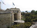
Main gate on the land side of the fort
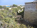
Casemate (right) with moat and glacis (left), a gallery can be seen in the moat

Back of the tower, above the entrance the coat of arms of de Rohan. In the foreground a position for a RML 64 pounder cannon
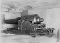
RML 10 inch 18 ton gun

RML 64 pounder 64 cwt Mk I gun, but here on a center pivot mount


literature
- Quentin Hughes : Malta. A guide to the fortifications. Said International, 1993, ISBN 9990943-07-9 .
- Stephen C. Spiteri : The Knight's Fortifications: an Illustrated Guide of the Fortifications built by the Knights of St. John in Malta. Book distributors limited, 2001, ISBN 9789990972061 .
- Charles Stephenson: The Fortifications of Malta 1530-1945. Osprey Publishing Limited, Wellingborough 2004, ISBN 1-84176-693-3 ( Osprey Fortress Series 16).
Web links
Individual evidence
- ↑ a b c d e f g h i j k l Quentin Hughes: Malta. A guide to the fortifications , ISBN 978-9990943078 , pp. 203ff
- ^ Treatise on the construction and manufacture of ordnance in the British Service. 1877 (English)
Coordinates: 35 ° 49 ′ 49 ″ N , 14 ° 32 ′ 37 ″ E