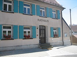
Frankenhofen (Ehingen)
|
Frankenhofen
City of Ehingen (Danube)
Coordinates: 48 ° 19 ′ 54 ″ N , 9 ° 36 ′ 7 ″ E
|
|
|---|---|
| Height : | 731 m above sea level NN |
| Area : | 11.1 km² |
| Residents : | 286 (Dec. 31, 2019) |
| Population density : | 26 inhabitants / km² |
| Incorporation : | 1st December 1973 |
| Postal code : | 89584 |
| Area code : | 07395 |
Frankenhofen (with the residential area Tiefenhülen ) is a suburb of the large district town of Ehingen (Danube) in the Alb-Danube district in Baden-Württemberg . The place was incorporated into Ehingen in 1973. Jutta Uhl is the head of the village.
history
Frankenhofen and its district Tiefenhülen were first mentioned in 1152. At least the Lords of Steusslingen were once involved in the suzerainty of the place. In 1270 the rights of the Steusslingers passed to Württemberg . They were then part of the fiefdom of the Lords of Freyberg . Local rule was transferred to the Cistercian monastery of Salem in the 13th century .
During the Thirty Years' War Frankenhofen was largely destroyed by the Swedes and the Württembergians in 1633.
The Swedes marching through on the military road from Münsingen to Ehingen partially burned Frankenhofen in 1633 and dragged the Catholic pastor Dyck to their field camp in Ehingen. There it was ransomed for the amount of 187 fl ( guilders ), which was received when the large church bell was sold to a neighboring community.
In 1634 the local church burned down except for the tower. It wasn't until much later that people settled in the village again, mainly immigrants from Switzerland. Since 1803 Frankenhofen and Tiefenhülen belonged to the Princes of Thurn and Taxis , who set up the care of Frankenhofen. In 1806, sovereignty fell to the Kingdom of Württemberg .
The parish and church of St. George were first documented in 1152, like the place. The nave and choir did not get their current appearance until the 18th century. The tower is late Gothic.
On December 1, 1973 Frankenhofen was incorporated into Ehingen with Tiefenhülen and has been its district ever since.
Individual evidence
- ^ From the district descriptions of the state of Baden-Württemberg. The Alb-Donau-Kreis Volume II. In: B. Community descriptions Ehingen to Westerstetten . Published by the Baden-Württemberg State Archives Directorate in conjunction with the Alb-Danube District, by Jan Thorbecke Verlag Sigmaringen 1992.
- ^ Federal Statistical Office (ed.): Historical municipality directory for the Federal Republic of Germany. Name, border and key number changes in municipalities, counties and administrative districts from May 27, 1970 to December 31, 1982 . W. Kohlhammer, Stuttgart / Mainz 1983, ISBN 3-17-003263-1 , p. 542 .

