
Erbstetten (Ehingen)
|
Erbstetten
City of Ehingen (Danube)
|
|
|---|---|
 |
|
| Height : | 608 m above sea level NN |
| Area : | 10.6 km² |
| Residents : | 186 (Dec. 31, 2019) |
| Population density : | 18 inhabitants / km² |
| Incorporation : | 1st December 1973 |
| Postal code : | 89584 |
| Area code : | 07386 |
 Erbstetten
|
|
The village Erbstetten is a suburb of Ehingen (Donau) in the Alb-Donau-Kreis ( administrative region Tübingen , state Baden-Württemberg , Germany) with the districts Erbstetten and Unterwilzingen . The Vogelhof hamlet also belongs to Erbstetten .
Erbstetten is suburb in the sense of the Baden-Württemberg municipal code, which means it has one of the eligible voters in each local election to be elected Ortschaftsrat (eight local councils) with a mayor as chairman. The entire area is part of the Swabian Alb biosphere area .
geography
Geographical location


Erbstetten is the most south-westerly suburb of Ehingen an der Donau and borders the Reutlingen district .
The Erbstetten district is located on the south-eastern edge of the Swabian Alb north of the Great Lautertal at 604 m above sea level. NN and is almost completely surrounded by forest.
Unterwilzingen , which belonged to Erbstetten even before the municipal reform, is located 1.5 kilometers south in the most scenic area of the Great Lautertal, which is only crossed by the K 7337 district road.
One kilometer east of Erbstetten is the Vogelhof hamlet on the plateau.
Neighboring places
The following places and communities border on Erbstetten. They are named starting in the north in clockwise order and, unless otherwise named, belong to Ehingen:
Granheim , Mundingen, Reichenstein ( Lauterach community ), Oberwilzingen (Hayingen community), Hayingen ( Reutlingen district ), Anhausen (Hayingen community).
Further location data
Erbstetten extends over an area of 10.76 km² . Josef Missel has been the mayor since 2014.
history

The Erbstetten and Unterwilzingen have had a common history only since 1825.
Erbstetten is first mentioned as " Erfstetim " in a deed of donation dated October 23, 805. Wago and Chadaloh I , sons of Count Perahtold, donated goods in the Alaholfsbaar , including "in Erfstetim cum omni marca sua, id est et illam terrem in suprior Wilzinga et inferiori" to the St. Gallen monastery . This place name goes back to the personal name Erph and is to be understood as "settlement of Erph". As a result, Erbstetten was probably created in the course of the older state expansion - around 800.
Evidence is only available again with the Counts of Wartstein. In 1143 there is evidence of a Rapoto (son of Count Heinrich I von Berg and Adelheids von Mochental ) who named himself after the castle Wartstein built for him or by him . In 1392 Count Heinrich sold the county and castle to the dukes Friedrich, Stephan and Johann of Bavaria. Already in 1394 they pledged the property for 600 fl to Walter von Königsegg , the family can be proven there until 1461. Erbstetten seems to have been badly devastated in armed conflicts around 1481, since in the spring of 1482 Duke Albrecht IV of Bavaria awarded five farms and three selden fiefs with the stipulation that the necessary housing and a barn should be built on the farm within one year. The nearby Monsberg Castle came into the possession of Hans Speth von Ehestetten between 1486 and 1489 .

In 1495, in a feud, Wartstein Castle and Erbstetten were destroyed by Hans Speth. In return, the Bavarians destroyed Monsberg Castle. Both castles were not rebuilt, Erbstetten remained desolate for a long time. In 1504, Duke Albrecht of Bavaria transferred the Wartstein fiefdom to Count Eitelfried von Zollern , who probably initiated the reconstruction of Erbstetten. As early as 1505 there was a pastor there again. In 1507/1508 Eitelfriedrich Erbstetten ceded parts of Ringingen to Hans Speth, son of the above-mentioned. Until the Reichsdeputationshauptschluss , Erbstetten remained in the possession of the Imperial Knight Speth zu Schülzburg in the knightly canton of Danube . The farms were granted as inheritance in 1523 with the right that every fiefdom holder received the necessary building and firewood from the feudal lord's forests. This right was satisfied in 1817 when Johann Baptist von Speth ceded 610½ acres of forest to the community. 1805 came the place to the Kingdom of Württemberg , there to the Oberamt Münsingen .
Unterwilzingen is probably even older. The name is derived from Wilzo , the ending -ingen indicates the older settlement around 500. Initially the hamlet belonged to the Wartstein fiefdom, but the Zwiefalten monastery received several donations soon after its foundation, and other parts of the hamlet belonged to Rechtenstein Castle . In 1825 Unterwilzingen came to the municipality of Erbstetten.
In 1842 the municipality of Erbstetten consisted of 20 farms and 10 farms. By 1848 all gradients were removed. In 1907 there were 37 farms, two restaurants and one pub.
In 1938 Erbstetten came to what was then the district of Ehingen.
On March 18, 1944, shortly before 3:00 p.m., the American B-17G "Fortress" bomber (ID no. 42-37832, "Casa de Embrigados") crashed around one kilometer south of Erbstetten. Five crew members were able to jump off in time, shortly before the plane hit another three men jumped out of the aircraft, but their parachutes no longer opened because of the low altitude. In Unterwilzingen and Erbstetten, many people had followed the last part of the flight and immediately rushed to the crash site, where they were able to rescue a wounded man from the burning plane. Behind the sacristy is a large wooden cross on the church, which originally stood on the grave of the American aviator who had crashed. In 2000 it was renovated and rebuilt here as a memorial for the victims of the air war.

Plane crash memorial stone

Inscription on the memorial stone

Old inscription memorial cross plane crash 1944


Incorporation
On December 1, 1973, the previously independent municipality of Erbstetten was incorporated into the city of Ehingen as part of the municipal territorial reform by resolution of the Erbstetten municipal council and has been a part of Ehingen since then.
logo

Since the formerly independent municipality did not have a coat of arms, Erbstetten cannot be awarded a new coat of arms today according to the municipal regulations for Baden-Württemberg. The local council therefore decided on a logo in December 2010. It is aligned with the logo of the city of Ehingen and shows the coat of arms of the Counts of Wartstein in addition to the stylized tower of the Wartstein ruins above the Great Lautertal.
Population development
- 1825: 186 inhabitants
- December 31, 2009: 207 inhabitants
- December 31, 2010: 204 inhabitants
- December 31, 2011: 194 inhabitants
- December 31, 2012: 198 inhabitants
- December 31, 2013: 198 inhabitants
- December 31, 2014: 192 inhabitants
- December 31, 2015: 187 residents (+ 21 asylum seekers in an accommodation in the district)
- December 31, 2016: 183 residents (+ 19 asylum seekers in an accommodation in the district)
Culture and sights
Museums
In the museum "Pastor Dr. Walz-Saal" in the former rectory you can find the old altar of the church and devices from Dr. med. Walz, the pastor in Erbstetten, can be seen.
Buildings
St. Stephen's Church

The church was built in the 16th century on the foundations of a much larger Romanesque three-nave predecessor church (mentioned in 1208). This was so big because the castles of Schülzburg, Wartstein, Monsberg and the surrounding villages (which have since been removed) were " parish ". It was probably destroyed along with the village in 1485.
For a small village church, today's church is almost "excessively" artistically designed. The frescoes, from the late 16th century of high quality and with a Northern Italian influence, were uncovered during the renovation in 1978/79. Life-size apostles are shown on a lettering that reproduces the Apostles' Creed . At the beginning of the lettering (under St. Petrus on the gallery) the scribe is also named: "Martinus Gerthauer, Schreiber zu Schilzburg". Above the four windows of the ship are the four evangelists who symbolically bring light into the church through their word. In the middle of the north side, Christ is depicted as judge of the world, below the kneeling kneeling with the (not preserved) banner, probably one of the prelates from Zwiefalten or Obermarchtal . At the choir arch the Last Judgment : on the left the righteous, who are led by angels from the graves to Christ, whom one has to imagine at the end of the choir arch (not preserved), on the right the damned, who are dragged by the devils into the jaws of hell. A painted Gothic altar can be seen on the left side of the choir, which once housed the tabernacle in a niche .
The Pietà on the high altar comes from the previous church and was built around 1420, the baptismal font is from 1591, the end of the construction period.
The frescoes on the rear wall of the choir, the two side niches (left: The Adoration of the Magi from the Orient, right: Baptism of Jesus) and the ceiling painting (Martyrdom of St. Stephen) in the nave are by Prof. Johannes Wohlfart from Rottenburg , who was in the church in 1943 worked. The picture above the side entrance (Schutzmantelmadonna) is from him.

fresco
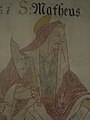
Fresco apostle Mathäus

Fresco Apostle Judas Thaddaeus

fresco

Fresco Apostle Andrew

Fresco Apostle Peter

Fresco Apostle James the Elder
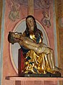
Pietà

St. Stefanus

Baptismal font from 1591


St. Georg branch chapel
The St. Georg branch chapel in Unterwilzingen was built in 1908, including the old building from 1724.

Chapel of St. Georg Unterwilzingen

Chapel of St. Georg Unterwilzingen, altar
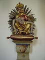
Chapel of St. Georg Unterwilzingen, little Pièta

Chapel of St. Georg Unterwilzingen, flag


Others
The former parsonage opposite the church from the same time as the Church of St. Stephen received the painted Renaissance facade and the window surrounds around 1600.
At Anhauser Straße 1 there is a half-timbered house from the same period that was renovated and modernized in 2002 under monument conservation aspects, and another renovated small half-timbered house at Dorfmolke 3.

Former rectory

Half-timbered house
Anhäuser Str. 3
Half-timbered house
Dorfmolke 3


Hiking area

Two long-distance hiking trails run by the Swabian Alb Association lead through the Erbstetten district : the Südrand-Weg HW 2 and the Schwarzwald-Schwäbische-Alb-Allgäu-Weg HW 5 . Both paths touch the Wartstein ruins. The HW 5 is on Erbstettener district identical to the Burgenweg Neckar Danube and also touches on the ruins Monsberg and St. Ruprecht .
A newly developed circular hiking trail "Field crosses around Erbstetten" opens up the landscape of the Voralb and leads past most of the field crosses in the district.
A nine-kilometer-long section of the hiking trail “Paths of reflection and contemplation on the Ehinger Alb” , certified as a quality trail , also runs along the district. As a supplement to the reflection path, the approximately seven kilometer long themed path “Our daily bread” runs along the Erbstetten district.
As part of a new hiking concept for the Alb-Danube district , the “Castle Rock Path” was redesigned in 2017. It runs mainly on sections of the above-mentioned Paths of Reflection and Contemplation and HW 2 .
Above Erbstetten on the road (K 7338) to Anhausen is the "Waldzeltplatz Berg" of the forest administration of the Alb-Danube district.
Economy and Infrastructure
The place is still largely agricultural with three full-time farmers and five part-time farmers (as of 2007).
A part of the Erbstetten-Frankenhofen primary school with 2 classes is located in the village . The gym and the teaching pool in the building are also available to the public.
The Vogelhof school camp of the city of Kornwestheim has been located in the Vogelhof hamlet since 1956 . The Evangelical Recreational Home Schlößle is next to it.
Web links
- Erbstetten (Ehingen) at LEO-BW
- Homepage of the city of Ehingen
- Homepage of the path of reflection on the Ehinger Alb
literature
- Johann Daniel Georg von Memminger : Description of the Oberamt Ehingen . Cotta-Verlag, Stuttgart and Tübingen 1826.
- K. Statist. State Office (Hrsg.): Description of the Upper Office Münsingen , revision. Kohlhammer, Stuttgart 1912
- Landesarchivdirektion Baden-Württemberg Ed .: District descriptions of the state of Baden-Württemberg, Der Alb-Donau-Kreis . Jan Thorbecke Verlag, Sigmaringen 1989, Vol. II
- Gunther Dohl: The Counts of Wartstein and their castles in the Lautertal . Working group of local museums in the Alb-Donau district, 1991, ISBN 3-88294-172-3
- Ludwig Ohngemach: On the history of Erbstetten and Unterwilzingen . In: Bulletin of the large district town of Ehingen (Danube) , West edition, 2005
- Peter Münch: Erbstetten . In: Hidden things brought to light , City of Ehingen Working Group Local Agenda 21, Ehingen 2006
- Otmar Gotterbarm: When the enemies fell from the sky . Library of Contemporary History, Zeitgut-Verlag, Berlin 2003, ISBN 3-933336-50-3
Remarks
- ↑ According to § 14 of the main statute of the city of Ehingen, the village consists of these two districts
- ↑ Erbstetten brought most of what is now Ehingen's forest property when it was incorporated in 1975.
- ↑ . On June 27, 1946, the dead were exhumed and reburied in the US war graveyard of St. Avold in Lorraine
- ↑ As the frescoes were exposed , underfloor heating was necessary. When they were installed, the foundations were found.
- ↑ During the work in 1978, traces of fire were found.
- ↑ http://www.architekt-steinhart.de/Projekte/Wohnbau/Wohn_haebe/wohn_haebe.html The half-timbered house on the Internet, accessed February 2, 2010
- ↑ There are two classes in Erbstetten and in Frankenhofen: 1st + 2nd school year and 3rd + 4th school year together.
- ↑ Schullandheim Vogelhof ( Memento of the original from March 26, 2010 in the Internet Archive ) Info: The archive link was inserted automatically and has not yet been checked. Please check the original and archive link according to the instructions and then remove this notice. , accessed February 2, 2010
- ^ Description of the Schlößle, accessed February 2, 2010
Individual evidence
- ^ Georg von Memminger, p. 147
- ↑ Fainting
- ↑ K. Statist. State Office, p. 642
- ↑ K. Statist. State Office, p. 641
- ^ Federal Statistical Office (ed.): Historical municipality directory for the Federal Republic of Germany. Name, border and key number changes in municipalities, counties and administrative districts from May 27, 1970 to December 31, 1982 . W. Kohlhammer, Stuttgart / Mainz 1983, ISBN 3-17-003263-1 , p. 542 .
- ^ In: Schwäbische Zeitung , 1979, No. 117, 182
- ↑ Hidden things brought to light, p. 45
- ↑ www.lokale-agenda-ehingen.de
- ↑ www.besinnungsweg-ehinger-alb.de ( Memento of the original from January 4, 2012 in the Internet Archive ) Info: The archive link was inserted automatically and has not yet been checked. Please check the original and archive link according to the instructions and then remove this notice.
- ↑ [1]
- ↑ [2]

Altbierlingen | Altsteusslingen | Mountain | Dächingen | Erbstetten | Frankenhofen | Gamer Swan | Granheim | Herbertshofen | Heufelden | Core city | Kirchbierlingen | Churches | Mundingen | Nose City | Cracks | Schaiblishausen | Volkersheim