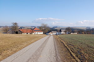
Freileben (community Altenfelden)
|
Freileben ( Rotte ) locality cadastral community Altenfelden |
||
|---|---|---|
|
|
||
| Basic data | ||
| Pole. District , state | Rohrbach (RO), Upper Austria | |
| Pole. local community | Altenfelden | |
| Coordinates | 48 ° 29 '44 " N , 13 ° 58' 25" E | |
| Residents of the village | 41 (January 1, 2020) | |
| Area d. KG | 12.52 km² | |
| Post Code | 4121 | |
| Statistical identification | ||
| Locality code | 10833 | |
| Cadastral parish number | 47202 | |
| Counting district / district | Altenfelden area (41304 001) | |
 The buildings Freileben 2 and 3 |
||
| Source: STAT : index of places ; BEV : GEONAM ; DORIS | ||
Freileben is a group of the Altenfelden community in Upper Austria ( Rohrbach district ). The village has 41 inhabitants (as of January 1, 2020).
geography
Freileben is in the eastern central area of the municipality of Altenfelden and in the north of the Altenfelden cadastral community. The settlement is about 1.2 kilometers north of Altenfelden's market square. Freileben is bounded in the east by the eastern municipality border, in the south and west by Rohrbacher Straße (B 127) and in the north by a forest. Neighboring towns are Fraunschlag in the north, Unterfeuchtenbach in the east, Langhalsen in the southeast, the market Altenfelden in the south, Godersdorf with Kainberg in the west and Haselbach in the northwest.
A total of 11 buildings were counted for outdoor living in 2001, with nine buildings having a main residence and 17 apartments or 15 households. There were also nine agricultural and forestry operations and two jobs. The buildings in the village are scattered individually or in small groups of a maximum of three houses, with the Union Altenfelden sports field (panorama stadium) and part of the Altenfelden industrial park also belonging to Freileben.
History and population
According to the place name researcher Konrad Schiffmann , the place name Freileben derives from "bei dem free Leb" (= Leo) . So a free man named Leo would have built a farm here. Likewise, a derivation of the place name from “Freilehen” would be conceivable, although here too the resident farmer would have had no master other than bishop and king. When Freileben was first mentioned in a document in 1379, however, it was already part of the Tannberg rule. Freileben could have been created together with the Altenfelden church between 1100 and 1200.
In 1869, 53 people lived in seven houses in Freileben. The population remained almost unchanged until 1910, with 50 residents in seven houses that year. The population was exclusively Catholic. In 1923 the population was 52 people, with the number of buildings remaining the same. However, the statistics differentiated between the group of six houses with 41 residents and a single farm with 11 residents. In 1951 only 41 people lived in Freileben, by 1971 the number of inhabitants rose again to 54 people in seven houses each. In 1981, 43 residents lived in eight buildings in Freileben.
Individual evidence
- ↑ Classification according to Statistics Austria
- ↑ Statistics Austria: Population on January 1st, 2020 by locality (area status on January 1st, 2020) , ( CSV )
- ^ Statistics Austria (ed.): Ortverzeichnis 2001. Oberösterreich. Vienna 2005
- ^ Katzinger: Altenfelden pp. 7–9
- ^ Kk statistical Central Commission (ed.): Orts-Repertorium des Erzherzogthumes Oesterreich ob der Enns. Based on the census of December 31, 1869 Linz 1871, p. 85
- ↑ kk Central Statistical Commission (Ed.): Spezialortsrepertorium von Oberösterreich. Edited on the basis of the results of December 31, 1910. Vienna 1916, p. 100
- ^ Federal Statistical Office (ed.): Directory of Austria. Edited on the basis of the results of the census of March 7, 1923. Vienna 1930, p. 19 Upper Austria
- ^ Austrian Central Statistical Office (ed.): Local directory of Austria. Edited on the basis of the results of the census of June 1, 1951. Vienna 1953, p. 92 Upper Austria.
- ↑ Austrian Central Statistical Office (ed.): Ortverzeichnis 1971. Upper Austria. Edited on the basis of the results of the census of May 12, 1971. Vienna 1976, p. 105
- ^ Austrian Central Statistical Office (ed.): Local directory 1981. Upper Austria. Vienna 1985, p. 235
literature
- Willibald Katzinger : Altenfelden. Review - panoramic view. Altenfelden municipal office 1978

