Radlau municipality
| Radlau Commune Gmina Radłów |
||
|---|---|---|

|
|
|
| Basic data | ||
| State : | Poland | |
| Voivodeship : | Opole | |
| Powiat : | Oleski | |
| Geographic location : | 50 ° 56 ' N , 18 ° 32' E | |
| Height : | 210-275 m npm | |
| Residents : | see Gmina | |
| Postal code : | 46-331 | |
| Telephone code : | (+48) 34 | |
| License plate : | OOL | |
| Economy and Transport | ||
| Next international airport : | Katowice | |
| Gmina | ||
| Gminatype: | Rural community | |
| Gmina structure: | 9 school offices | |
| Surface: | 116.73 km² | |
| Residents: | 4308 (Jun. 30, 2019) |
|
| Population density : | 37 inhabitants / km² | |
| Community number ( GUS ): | 1608052 | |
| Administration (as of 2014) | ||
| Wójt : | Włodzimierz Kierat | |
| Address: | ul.Oleska 3 46-331 Radłów |
|
| Website : | radlow.pl | |
The municipality Radlau ( Polish Gmina Radłów ) is a rural municipality in the powiat Oleski of the Opole Voivodeship in Poland . It has around 4400 inhabitants and has been officially bilingual (Polish and German) since 2006. Their seat is the village of the same name with about 600 inhabitants.
geography
The rural community is located in the northeast of the voivodeship on the Silesian plateau and borders the district town of Olesno (Rosenberg OS) . Częstochowa (Czestochowa) is 30 kilometers southeast. The northern municipal border forms the border between Upper Silesia and Lesser Poland . The largest flowing water is the Prosna , which rises near Wollentschin. The Prąd brook also has its source in the municipality.
The municipal area covers an area of 116.73 km², 59.3% of which are used for agriculture and 34.5% for forestry. Forests mainly occupy the south of the municipality.
Neighboring communities are in the north Rudniki , in the east Krzepice , in the south Olesno and in the west Gorzów Śląski (Landsberg OS) .
history
The municipality was founded in 1946 as Gmina Sternalice . The smaller Radłów became the seat of the municipality in 1952. From 1975 to 1998 the municipality belonged to the Częstochowa Voivodeship .
The municipality of Radlau became officially bilingual in 2006 - in accordance with the Polish minority law of 2005 - and in 2007 a municipal resolution to set up bilingual place-name signs was approved by the Ministry of the Interior. On September 12, 2008 Radlau was the first municipality in Poland to set up bilingual place-name signs.
- coat of arms
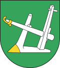
Blazon : The coat of arms of the municipality shows a silver plow in green .
The coat of arms was introduced in this form in 2001. It is a talking coat of arms , as the place name is derived from the word radło (= plow). The green color of the sign stands for the importance of agriculture in the community.
structure
The rural municipality of Radlau consists of the following villages with a Schulzenamt (sołectwo):
| District | Inhabitants 1910 |
Population 2007 |
|---|---|---|
| Bischdorf / Biskupice | 1,050 | 435 |
| Friedrichswille / Kolonia Biskupska | 186 | |
| Kostellitz / Kościeliska | 961 | 737 |
| Ellguth / Ligota Oleska | 631 | 395 |
| New Karmunkau / Nowe Karmonki | 739 | 449 |
| Radlau / Radłów | 561 | 627 |
| Sternalitz / Sternalice | 950 | 838 |
| Wichrau / Wichrów | 603 | 427 |
| Wollentschin / Wolęcin | 204 | 146 |
The rural community includes three other localities that do not have the status of a Schulzenamt: Straßenkrug / Biskupskie Drogi , Psurow / Psurów and Alt Karmunkau / Stare Karmonki .
politics
Community leader
The head of the municipal administration is the municipality leader . Since 2014 this has been Włodzimierz Kierat from the German minority. The regular election in October 2018 brought the following result:
- Włodzimierz Kierat ( German Minority Election Committee ) 55.1% of the vote
- Justyna Szoprun (Election Committee “Local Work”) 44.9% of the vote
Kierat was thus re-elected in the first ballot.
Municipal council
The municipal council consists of 15 members and is directly elected in single-person constituencies. The 2018 municipal council election led to the following result:
- Election committee German minority 52.3% of the vote, 10 seats
- Election Committee "Local Work" 19.6% of the vote, 1 seat
- Election Committee Łukasz Kansy 13.1% of the vote, 3 seats
- Polskie Stronnictwo Ludowe (PSL) 11.9% of the vote, 1 seat
- Electoral committee Marek Lotza 3.1%, no seat
education
There is a middle school (gimnazjum) in the main town. The municipality maintains a library, a village community center (Ośrodek Kultury) and a kindergarten in Radlau .
Web links
- Community website (Polish)
Individual evidence
- ↑ population. Size and Structure by Territorial Division. As of June 30, 2019. Główny Urząd Statystyczny (GUS) (PDF files; 0.99 MiB), accessed December 24, 2019 .
- ↑ Gmina radlow.pl
- ↑ Polish Interior Ministry: Dz.U. 2006 no. 17 poz. 141 (Polish)
- ↑ n-tv.de: New Normality , September 12, 2008.
- ↑ Result on the website of the election commission, accessed on August 12, 2020.
- ↑ Result on the website of the election commission, accessed on August 12, 2020.


