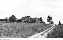
Gleina (Malschwitz)
|
Gleina
Hlina Community Malschwitz
Coordinates: 51 ° 14 ′ 25 ″ N , 14 ° 33 ′ 44 ″ E
|
|
|---|---|
| Height : | 148 m above sea level NN |
| Residents : | 148 (December 31, 2016) |
| Incorporation : | July 1, 1950 |
| Incorporated into: | Buchwalde |
| Postal code : | 02694 |
| Area code : | 035932 |
Gleina , Upper Sorbian , is a village in the East Saxon district of Bautzen and has been part of the Malschwitz community since 1994 . It belongs to Upper Lusatia and is located in the Sorbian settlement area .
geography
Gleina is about 12 km northeast of Bautzen at 148 m above sea level. NN. It is overlooked by the 168 m high Windmühlenberg. Gleina is an extended dead end village and the last place on the Kotitzer Wasser before it flows into the Löbauer Wasser . There is an estate in the eastern part of the village. The district of Kleingleina is to the north.
history
The place is first mentioned in 1433 as Cleyne ; the current spelling is first recorded in 1510. The place name comes from the Sorbian word for clay or loam ( old Sorbian glina , today hlina ). At the Upper Lusatian Pönfall in 1547, the settlement was owned by the city of Bautzen. In 1604 the first manor was mentioned in Gleina.
On May 20 and 21, 1813, Gleina was on the northern edge of the main battle area of the Battle of Bautzen when French troops fought against Prussians and Russians. The headquarters of the allies was located near the village on Windmühlenberg.
Gleina was an independent rural community until June 30, 1950, when it was incorporated into Buchwalde . From 1974 to 1994 it belonged to Baruth . Since then it has been part of the Malschwitz community.
population
Around 1900 Gleina had about 340 inhabitants.
The majority of the believing Gleina residents are traditionally Evangelical Lutheran. The place has belonged to the Guttau parish since the 16th century .
For his statistics on the Sorbian population in Upper Lusatia, Arnošt Muka determined a population of 223 inhabitants in the 1880s; 202 of them were Sorbs (91%) and 21 Germans.
traffic
The next junction of the Autobahn 4 ( Bautzen-Ost ) is about 10 km away. Local roads connect Gleina with Guttau (3 km), Malschwitz (3 km), Buchwalde (1 km) and Preititz (4 km).
The Löbau – Radibor railway passed Gleina directly to the south; the nearest train station was in Guttau. It was finally shut down in 1995 and is now dismantled.
Web links
- Gleina in the Digital Historical Directory of Saxony
swell
- ^ Walter Wenzel: Oberlausitzer Ortnamesbuch. Domowina-Verlag, Bautzen 2008, p. 67
- ↑ Marion Völker: The urban constitution from the beginnings to the Pönfall in 1547 in From Budissin to Bautzen , Lusatia, Bautzen 2002
- ↑ Digital Historical Directory of Saxony
- ↑ Ernst Tschernik: The development of the Sorbian population . Akademie-Verlag, Berlin 1954, p. 50 .


