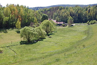
Gleiritsch (river)
| Slip | ||
|
The Gleiritsch at the cabbage mill |
||
| Data | ||
| Water code | EN : 14498 | |
| location | Schwandorf district | |
| River system | Danube | |
| Drain over | Pfreimd → Naab → Danube → Black Sea | |
| source | west of Zeinried 49 ° 29 ′ 59 ″ N , 12 ° 20 ′ 59 ″ E |
|
| Source height | 527 m | |
| muzzle | south of Trausnitz in the Pfreimd Coordinates: 49 ° 30 '52 " N , 12 ° 15' 31" E 49 ° 30 '52 " N , 12 ° 15' 31" E |
|
| Mouth height | 389 m | |
| Height difference | 138 m | |
| Bottom slope | 14 ‰ | |
| length | 9.9 km | |
| Catchment area | 28.84 km² | |
| Left tributaries | Kroaubach, Klingenbach | |
| Right tributaries | Mühlbach, Schweizerbach | |
| Communities | Gleiritsch , Pfreimd , Trausnitz | |
The Gleiritsch is a 9.9 km long left and eastern tributary of the Pfreimd in the Upper Palatinate in Bavaria . It rises from several sources southwest of Zeinried and flows into the Pfreimd near Trausnitz .
Surname
The name comes from Slavic and contains the educational elements slav.glova 'ground elevation' and slaw.rěčica 'small brook', so it means 'raised ground by a small brook'. The Gleiritsch flows past the elevation with the village of Gleiritsch near the Kohlmühle near Bernhof , which is the motivating factor for the name .
course
The Gleiritsch rises west of Zeinried in the valley of Ödmiesbach and Zeinried and flows quite steadily to the west. At Lampenricht the Mühlbach coming from the direction of Tännesberg flows past the Neumühle, Schnegelmühle and Boxmühle into the Gleiritsch. The Gleiritsch flows past the Kohlmühle and Bernhof in the direction of Bornmühle , Bornmühlschleife, Atzenmühle near Atzenhof and joins the Pfreimd south of Trausnitz .
Tributaries
Listed downstream by estuary. Position and lengths (measured there) according to the BayernViewer.
- Mühlbach , from the right at the southwest end of Lampenricht next to Seebergstrasse, 4.84 km. Flows from the lowest of several lakes in a wide basin north of the Bürschling.
- Kroaubach , from the left at the Gleiritscher Kohlmühle , 2.44 km. Originates in the Fichtental east of the Großer Kulm
- Klingenbach , from the left immediately after passing the Pfreimder Bornmühle, approx. 1.4 km. Arises northwest of the Großer Kulm.
- Schweizerbach , from the right in front of the Pfreimder Bornmühleschleife into the Gleiritsch brook itself, 2.95 km. Arises below the drum space.
Picture gallery
Headwaters near Zeinried
The slip at Lampenricht
The Gleiritsch flows into the Pfreimd near Trausnitz
literature
- Schwarz, Ernst: Language and Settlement in Northeast Bavaria. Nuremberg 1960
- Bavarian Land Surveying Office, Map L 6540, Oberviechtach
- Bavarian Land Surveying Office, Map L 6538, Nabburg
Individual evidence
- ↑ a b c d BayernAtlas of the Bavarian State Government ( notes )
- ↑ a b c d e Directory of brook and river areas in Bavaria - Naab river area
- ^ Schwarz, Ernst: Language and Settlement in Northeast Bavaria. Nuremberg 1960, p. 312
- ↑ Length measured according to: BayernAtlas of the Bavarian State Government ( notes )
- ^ Name of the residence of a mill.
Web links
- "BayernAtlas": Gleiritsch at BayernAtlas


