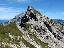
Great Palfelhorn
| Great Palfelhorn | ||
|---|---|---|
|
Wimbachtal with Palfelhorns (right) - Kühleitenschneid - Hundstod (left) |
||
| height | 2222 m above sea level NHN | |
| location | Border Bavaria - Salzburg near Ramsau near Berchtesgaden and Weißbach near Lofer | |
| Mountains | Berchtesgaden Alps : Hochkaltergebirge resp. Stone Sea | |
| Dominance | 0.97 km → Seehorn | |
| Notch height | 74 m ↓ Hochwiesscharte | |
| Coordinates | 47 ° 31 '40 " N , 12 ° 51' 44" E | |
|
|
||
| rock | Ramsaudolomit | |
The Große Palfelhorn (also Palfenhorn, Balfenhorn, Palvenhorn ) is a 2222 m high peak in the Berchtesgaden Alps , on the border between Bavaria and Salzburg .
location
The Große Palfelhorn, like the Kleine Palfelhorn ( 2073 m , to the north, collectively called Palfelhorn ), is located at the end of the Berchtesgadener Wimbachtal and above the Weißbachtal near Lofer in Pinzgau . The border between Germany and Austria runs at the summit .
The Hochkalter rises to the north, the Watzmann to the northeast , the Große Hundstod to the southeast , and the Hocheisspitze to the northwest .
The Wimbachscharte ( 2004 m , southeast of the Kühleitenschneid (minimum around 2020 m )) follows directly northwest of the ridge . As a result, the Palfelhörner and the south-facing Seehorn ( 2321 m ) at the Dießbach reservoir (between the Hochwiessattel , approx. 2040 m ) form a small subgroup. On the Bavarian side, this is included in the southern Wimbach chain of the Hochkaltergebirge , and on the Austrian side usually in the Steinerne Meer .
The name stands for Palfen 'rock'. The brittle Ramsaudolomit gives the summit its appearance.
Approaches
The Große Palfelhorn can be reached from the Wimbachscharte (from the Wimbachtal from the Wimbachgrieshütte ) or from the Hochwiessattel (crossing the Seehorn, from the Dießbachtal or from the Ingolstädter Haus , the latter both via the Hochwies) via the brittle southwest ridge. The partially slipped, sparsely marked path leads mostly to the right of the ridge to the summit cross.
Individual evidence
- ↑ Max Zeller: The Hochkalter Mountains. In: Heinrich Heß (Ed.): Journal of the German and Austrian Alpine Association , Part 1 1914, pp. 177–218, Part 2 1915, pp. 157–200.
- ↑ mountain group classification according to Trimmel ; Lukas Plan: Verbal description of the delimitation of the subgroups of the Austrian cave directory . Status: January 8, 2008. Ed .: Association of Austrian Cave Researchers. ( hoehle.org [PDF; 321 kB ; accessed on May 15, 2018]).


