
Hochkalter
| Hochkalter | ||
|---|---|---|
 Highly cold with blue ice from the north |
||
| height | 2607 m above sea level NN | |
| location | Bavaria , Germany | |
| Mountains | Berchtesgaden Alps | |
| Dominance | 4.5 km → Watzmann | |
| Notch height | 621 m ↓ Wimbachscharte | |
| Coordinates | 47 ° 34 '9 " N , 12 ° 51' 56" E | |
|
||
| First ascent | Prince-Bishop Schwarzenberg with Gemminger, Tatz and Wein, 1830 | |
| Normal way | about the "beautiful spot" from the Blaueishütte , II | |
| particularities | The easiest ascent is not the normal route, but the route from the Ofental, I. | |


The Hochkalter in the Berchtesgaden Alps is with a height of 2607 m the highest peak of the mountain range of the same name (also: Hochkaltergebirge, Hochkalterstock, Hochkaltermassiv) and thus one of the highest mountains in Germany . The Hochkalter massif is located to the west of the Watzmann massif and, like this one, lies in the Berchtesgaden National Park . The Hochkaltergebirge is divided into the subgroups Hochkalter Group , Hocheis Group and Southern Wimbach Range . The most important base of the mountain range is the Blaueishütte of the German Alpine Club at 1653 m above sea level in the Blaueiskar below the Blaueis , the northernmost glacier in the Alps . Other refuges are the Hirschbichl mountain home for the Hocheisgruppe , the Wimbachgrieshütte for climbs on the eastern flank of the massif and the Ingolstadt house for the southern Wimbach chain .
Geology of the Hochkaltergebirge
Like the entire northern Limestone Alps, the Hochkaltergebirge consists of a mixture of dolomite and limestone . In the Hochkalter and Hocheis groups there is mainly the more solid Dachstein limestone , which can be traced back to deposits in the Tethys in the Younger Triassic (220 million years ago). When the Alps were formed, the banked Dachstein limestone layers were tilted at an angle of 30 ° to 40 ° due to the tectonic plate movement of the African and European continental plates , which is clearly visible on the Hochkalter massif, especially in the Ofental. The southern Wimbach chain consists largely of brittle Ramsaudolomite , which has contributed significantly to the gravel of the Wimbach valley .
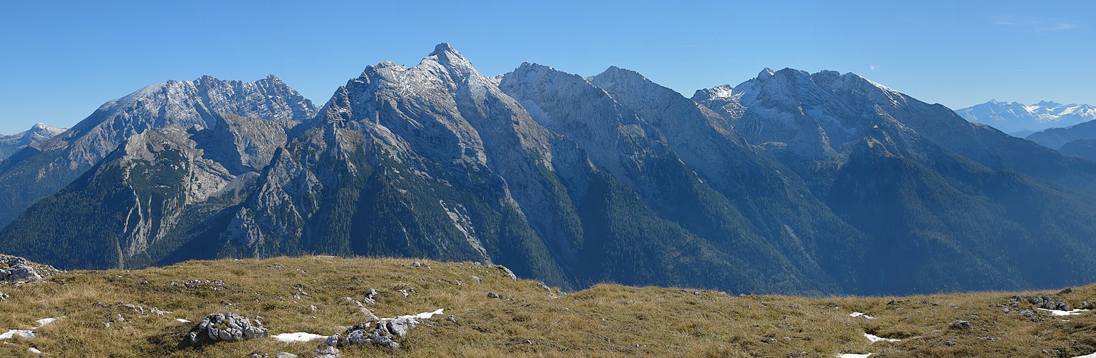
View from the Reiter Alm over the entire Hochkaltergebirge, on the left in the picture also Kahlersberg and Watzmann and on the far right the Glockner group

Landslides
There were always major landslides on the Hochkalter massif . In prehistoric times - around 3500 years ago - more than 15 million m³ of rock fell from the upper Blaueiskar into the valley. The Hintersee was also dammed by this landslide . The big boulders in the magic forest still bear witness to this tremendous event. But even in recent times there have been frequent rockfalls on a large scale:
- On August 24, 1908, the summit structure of the Hochkalter crashed and changed the shape and height of the summit significantly. The volume of the broken rock is estimated at 240,000 m³. The rock fall was felt as an earthquake in the Ramsau valley.
- On July 25, 1954, the second Blaueisturm in the north ridge of the Blaueisspitze collapsed.
- Nine years later, on July 25, 1963, the demolition of a pillar at the top of the Schärtenspitze led to significantly increased difficulties in the north face route.
- In February 1959, several hundred thousand cubic meters of rock slid from the Palfelhorn area on the snow underlay into the rear Wimbach valley.
In general, the fragility of the rock in the Wimbachtal is particularly clear. The bottom of the valley is covered by flowing rubble of great thickness. This magnificent landscape can be experienced by anyone who hikes the valley from Ramsau (Wimbachbrücke car park) first through the Wimbachklamm and then on the opening valley floor (approx. One hour to Gasthaus Wimbachschloss , another hour to the Wimbachgrieshütte, 1327 m ).
Alpinism
Hochkalter

The Hochkalter ( 2607 m ) with its Trabanten is a versatile and worthwhile area for tours of all kinds. The alpinist has all possibilities from simple mountain hikes to climbing trips in all degrees of difficulty to ski tours. The very cold can even come up with a challenging glacier ascent. The summit ascents are only suitable for experienced mountaineers. The route taken in 1830 by the first ascent, Bishop Fürst Schwarzenberg and his guides Gemminger, Tatz and Wein through the Hochkalter west flank (through the so-called Kaltergraben ) never became popular because it is difficult to find and hunting interests previously opposed an inspection.
Hochkalter normal route over the »beautiful spot«

The Hochkalter normal route, a partly exposed and long ridge climb, was climbed for the first time in 1833 by Karl Thurwieser and the guide Wein. It has several places in the second degree of difficulty on the UIAA scale. The ascent leads from the Blaueiskar over a steep gully to the ridge of the »Schönen Flecks«, from which you follow the ridge in a southerly direction over Rotpalfen and Kleinkalter to the main summit (approx. 3½ hours from Blaueishütte).
Through the furnace valley
The ascent through the Ofental is somewhat easier (difficulty level I) than the route over the Schönen Fleck . However, orientation is more difficult and there is no hut on the way. In the upper Ofental, extensive debris fields make the ascent difficult. This is why the route through the valley is more often climbed downhill than uphill. In spring the Ofental is a popular ski tour.
Over the blue ice and the east ridge
This ascent, first carried out by the Ramsau mountain guide Johann Grill (called Kederbacher) in 1874 with E. Richter, is significantly more demanding than the lead over the Schönen Fleck or the Ofental route. It leads from the Blaueishütte over the glacier to the approx. 2400 m high Blaueisscharte and from there over the east ridge to the summit. The steepness of the ascent on the glacier is up to 50 °. The most favorable season for the inspection is usually the early summer, as later in the year the increasing evaporation increasingly exposes bare ice and the difficulties in crossing the rift below the blue ice gap increase significantly. The saddle separates the Hochkaltergipfel from the 2480 m high Blaueisspitze. This was first entered on the occasion of a new tour on the Hochkalter on June 14, 1885 by the Salzburg gymnastics teacher Ludwig Purtscheller and is easy to "take" from the saddle. Above the Blaueisscharte in the rocks of the Hochkalter east ridge, longer passages in the second degree of difficulty have to be mastered.
Blue ice cream framing
Experienced alpinists also like to climb the so-called "blue ice framing", which leads from the Eisbodenenscharte over blue ice towers, blue ice peaks, high and low ages as well as the red palfen back to the blue ice hut. Up to the Blaueisspitze it is a climb in the fourth degree of difficulty on the UIAA scale. If you touch the route, you can see from Schärtenspitze and Steinberg, all of the peaks that surround the Blaueis Glacier in a horseshoe shape .
Schärtenspitze

The summit of the Schärtenspitze ( 2153 m ) can be reached from the Blaueishütte in around 1¼ hours on a marked trail. The summit panorama is characterized by the Blaueis Glacier and its frame, the Watzmann west flank and the Reiteralm . If you don't want to go back to the Blaueishütte, there is a worthwhile alternative to descend over the Eisbodenscharte to the lonely high alp (level of difficulty I) and further into the Wimbachtal. Some wire rope insurances are in place both on the ascent from the hut and on the descent from the Eisbodenscharte to the Hochalm. In addition, the top of the Schärtenspitze is also a popular destination for climbers in a sharper direction, to which the short approaches from the Blaueishütte may also have contributed. Several routes of higher levels of difficulty lead through the north and north-east face.
Ofentalhörnl

The Ofentalhörnl ( 2513 m ) has two peaks. The main summit can only be reached by easy climbing and is rarely climbed. The normal route leads from the Ofental through the north flank, which is criss-crossed by flat ribbons, and has passages in the second degree of difficulty. In contrast, the south-west summit, which is a few meters lower, can easily be reached from the Steintal via the Steintalscharte. This route is a popular ski tour in spring.
Hocheisspitze
→ Main article: Hocheisspitze
The highest peak of the Hocheisgruppe, the Hocheisspitze ( 2523 m ), is unmarked and very difficult to reach through the Hocheiskar. The first tourist ascent was carried out by Hermann von Barth in 1868. The summit is the highest point of the so-called high ice framing, one of the longest closed ridge climbs in the Berchtesgaden Alps (third degree of difficulty, 10 to 14 hours). In spring the Hocheisspitze is a very popular ski touring destination.
Kammerlinghorn
The Kammerlinghorn ( 2483 m ) is the southernmost peak of the Hocheisgruppe and has a large summit cross. A marked trail leads from the Hirschbichl pass to the summit, either via the north side via Bindalm and Mittereisalm , or from the south via the Kammerlingalmen. The ridge starting at the summit of the Kammerlinghorn forms the frame of the Hocheiskares with the Hochkammerlinghorn, Hocheisspitze, Hinterberghorn and Hocheishörnl.
Palfelhörner – Seehorn

The three peaks Kleines Palfelhorn ( 2073 m ), Großes Palfelhorn ( 2222 m ) - both also called Palfenhörner, Balfenhörner, Palvenhörner - and Seehorn ( 2321 m ) form a subgroup standing across the southern Wimbach chain (Großes Palfelhorn in the main ridge) between Wimbachscharte and Kühleitenschneid . On the Austrian side, this small group is usually counted as part of the Steinerne Meer in the vicinity of Hundstod (from Wimbachscharte).
The Palfelhorns are made of brittle Ramsaudolomite , the Seehorn of Dachstein limestone . The latter is to be crossed on the marked path, the Große Palfelhorn, on the other hand, is already climbing, the Kleine Palfelhorn even in the 2nd degree. At the time, it was considered the most difficult ascent in the Berchtesgaden Alps, along with the east face of the Watzmann. To the west of the Seehorn is the Kallbrunnalm , one of the largest alpine pastures in the Berchtesgaden Alps.
An overview of the peaks of the Hochkaltergebirge


-
Hochkalter group
- Hochkalter, 2607 m
- Ofentalhörnl, 2513 m
- Small age, 2513 m
- Blauerisspitze, 2480 m
- Steintalhörnl, 2468 m
- Schönwandeck, 2450 m
- Rotpalfen (Wasserwandkopf), 2367 m
- Schärenspitze, 2153 m
- Schartenwandkopf, 2065 m
- Steinberg, 2065 m
- At the dog, 1803 m
- Stanglahnerkopf, 1791 m
- Schottmalhorn, 1662 m
-
Hocheis Group
- Hocheisspitze , 2523 m
- Hinterberghorn, 2493 m
- Kammerlinghorn, 2483 m
- Wimbachschneidspitze, 2368 m
- Hinterbergkopf, 2247 m
- Hocheishörnl, 2252 m
- Karlkogel, 2195 m
- Eislhörnl, 2095 m
- Vorderberghörnl, 2083 m
- Kleineishörnl, 1934 m
-
Southern Wimbach range
- Seehorn , 2321 m
- Alpelhorn, 2254 m
- Great Palfelhorn , 2222 m
- Prunnerkopf, 2076 m
- Kleines Palfelhorn , 2073 m
- Kühleitenschneid (connecting ridge between the Great Hundstod and the Great Palfelhorn)
- Sigeretkopf, 2066 m
literature
- Max Zeller: The Hochkaltergebirge , part 1, in: Heinrich Heß (ed.): Journal of the German and Austrian Alpine Association 1914 , Vienna 1914, pp. 177-218.
- Max Zeller: The Hochkaltergebirge , part 2, in: Heinrich Heß (ed.): Journal of the German and Austrian Alpine Association 1915 , Vienna 1915, pp. 157-200.
Web links
- Homepage of the Blaueishütte
- Hochkalter route description with pictures on tourentipp.de
Individual evidence
- ↑ According to information from the Bavarian Land Surveying Office from 2008, the exact height is 2606.9 m . The information of 2606 m , which differs in some maps, is due to the deletion of the decimal place without rounding.
- ↑ mountain group classification according to Trimmel ; Lukas Plan: Verbal description of the delimitation of the subgroups of the Austrian cave directory . Status: Jan. 8 2008. Ed .: Association of Austrian Speleologists. ( hoehle.org [PDF; 321 kB ; accessed on May 15, 2018]).