
Hadelner Canal


The Hadelner Canal (also Hadeler or Hadler Canal ) is part of the Elbe-Weser shipping route . It is an approximately 32 km long navigable drainage canal between the Elbe near Otterndorf and the lake near Bad Bederkesa . From there the Bederkesa-Geeste Canal (1858-1860) continues to the Geeste and to Bremerhaven . The Hadelner Canal was built from 1852 to 1854. Today, in addition to drainage, it is mainly used for small Kümos (coasters) and pleasure boats as a shortcut between the Weser and the Elbe.
The canal is designed for ships such as coasters and barges with a length of up to 33.5 and a width of up to 5 m. A draft of up to 1.5 m is possible and, due to the many bridges, a maximum height of 2.7 m. This official information is only of a theoretical nature, as the sewer is no longer "managed" and reports of deviations are increasing.
The Hadelner channel has a lock in Ottersdorf that both sewer drainage, as well as a chamber lock is used for navigation. In the further course of the Elbe-Weser shipping route there is the Lintiger lock on the Bederkesa-Geeste Canal and the third one in the Bremerhaven tide barrier on the Geeste. The so-called "Schiffdorfer Stauschleuse" is a sewage system that is no longer in operation without a lock chamber.
history
After repeated severe floods in Sietland, the respected Captain Böse from Bederkesa promoted a major drainage project, the Hadelner Canal, which had already been planned several times in the past but was never realized.
A draft drawn up in 1832 on the initiative of Landdrostei Stade envisaged dividing the area into two drainage areas. The water from the area around Bederkesa was to be fed directly to the Elbe through a peripheral channel. In 1834 the Landdrostei ordered the building. The farmers of the highlands again got a respite because they did not benefit from the drainage themselves, but should share in the costs.
The Hadler Canal was built between 1852 and 1854 about 20 years later. Around 1150 workers moved a million cubic meters of earth. A 31.7 kilometer long canal was created with a bed width of 8.2 to 12.3 meters. The Neuhaus-Bülkau Canal was also built from 1852 , which led the moor waters of the Balksee into the Oste . This put an end to the frequent floods that hit the Sietland in particular practically every winter and after heavy rains in summer. The previously relatively backward Hadler Sietland experienced a considerable economic boom.
Likewise, by draining the moors, the previously rampant malaria (" marsh fever ") was contained. In 1859, the Geeste-Weser Canal was also opened, so that an important inland connection for freight traffic between the Elbe and Weser was created via the Bederkesaer See. At the end of the 19th century there was also an important structural change in agriculture. Because of cheap grain imports from overseas, arable farming declined in the highlands and grassland farming (beef fattening) gained in importance.
However, the channel alone did not have the desired effect. Only the construction of the various side canals and receiving waters as well as the Otterndorfer pumping station brought the desired success and a significant improvement in life.
Between 1957 and 1965 the Hadelner Canal was deepened considerably and expanded to a bottom width of 14 meters.
course
The canal begins hydrologically and hydrographically at the Lintig lock , which marks the watershed between the Lower Weser and Lower Elbe. In contrast, it is still part of the Bederkesa-Geeste Canal up to Bederkesa Castle . From here it lies in the former Medem overflow, known as the Aue. After recording the current artificial Flögelner lake drainage (GKZ: 39924) it turns to the east and crosses the old Medem / Aue tributary Mühe. In fact, the southern upper reaches of the Mühe (GKZ: 59926) flows into the canal by means of a pumping station.
The northern part of the effort is insignificant for the water balance today and is interrupted in some places. The canal flows northeast for the next six kilometers, crossing the once great Medem tributary Gösche . Here the water is lifted from its upper course into the canal. The lower course of the Gösche (GKZ: 5992728) is reversed today, its water enters the canal through the main receiving water Steinau (GKZ: 599272). Its pumping station is 870 m upstream of the upper Gösche pumping station.
Before Bovenmoor he turns left. Here it was led in the border area between the river basin of the Medem and the Oste tributary Aue straight northwards to the Elbe dike. There are no inflows from adjacent areas on this route, but the possibility of draining water from the canal through the Kehdingbrucher Wetter (GKZ: 5988392) and the Aue (GKZ: 598839) in the direction of Oste (GKZ: 598).
On the back of Hadelner Elbdeichs the channel runs and west is a Dredge - lock passed outer dike. On the back of the dike there is a cross-connection to the Medem called a “piercing”. It makes it possible to use the Otterndorf pumping station to drain the canal when there is a large amount of surface water , primarily the eastern one of its two completely separate systems, the so-called "Disel pumping station", which is now electrically operated.
Halfway from the sluice to the banks of the Elbe, the Hadelner Canal joins the Medem (GKZ 2994) or the Medem-Außenentief. Statistically, both bodies of water are considered separately.
“Steinau receiving water” pumping station, clearly recognizable: the low water level in the receiving water
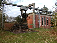
Bucket for the goose, the rake is freed from floating debris

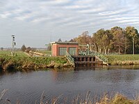
Otterndorf pumping station from the north, left “Diesel pumping station”, today for the canal, right “Electric pumping station” for the Medem


River system as a list
This list represents only a selection from the complicated drainage network. It shows that there are flow paths that are longer than the canal stretch from the Lintig lock to the Elbe.
Explanations:
- Upstream sequence, at the beginning of the line distances of the mouths and branches from downstream mouths.
- Where in a line the indication of the connection side has been moved below the water code number of a body of water listed above, the water body mentioned in this line connects to the one under whose water code number its side is indicated.
- Distances highlighted in gray from an estuary from the confluence of the Hadelner Canal into the Elbe are partly in waters that are fed into it.
- The (upper) bog floodplain has several drainage paths and is therefore entered several times with a stronger background color.
| km from the Elbe | km from the previous estuary; Inflow from / A BZWEIG NACH ; Water code |
Surname | length | km origin → Elbe |
Origin; Catchment area; (Remarks) |
||||
| 0 | 3992 | Hadelner Canal | 34.3 | 34.3 | Lintig lock ; 301.5 km² | ||||
| 20.08 | right | 59928 | Stinstedter Rand Canal | 17.35 | 37.45 | Lamstedt ; Stinstedt, Moorausmoor, Mittelstenahe | |||
| 28.17 | 8.09 | AFTER LI | 59926 | Gösche (south) | s. u. | ||||
| 28.45 | 8.37 | Left | 5992816 | (lower) bog floodplain | 1.72 / 7.31 | (Cross connection) | |||
| 30.17 | 10.09 | 1.72 | AFTER LI | 59926 | Trouble ((south)) | s. u. | |||
| 59926 | Bog floodplain | 5.53 | 35.7 | Bull lake; between Moorausmoor and Armstorf | |||||
| 22.0 | right | 599274 | Gösche (south) | see above; Moorausmoor, Neu- and Altbachenbruch (eastern part) | |||||
| 22.87 | Left | 599272 | Steinauer receiving water | 3.5 | arises from five tributaries at a double water crossing | ||||
| 23.21 | 0.34 | Left | 5992728 | Goose (North) | |||||
| 25.01 | right | 59926 | Trouble | 7.65 / 13.16 | weaker branch of the upper moorland; Area around Mühedeich and Meckelstedter Moor | ||||
| 32.66 | 7.65 | AFTER RE | 5992816 | Bog floodplain | for the Stinstedter Randkanal s. O. | ||||
| 59926 | Bog floodplain | 5.53 | 38.16 | Bull lake; between Moorausmoor and Armstorf |
|||||
| 27.4 | Left | 599252 | Lehe | 3.45 | today the second outflow of the Flögelner See | ||||
| 27.8 | Left | 59924 | Flögelner lake drainage | 3.0 | |||||
| 30.0 | 2.2 | right | 599244 | Fickmühlen Rand Canal ← Bahlenbach | 10.6 | 40.6 | to the west of Bederkesa | ||
| 30.8 | 3.0 | 59924 | Flögelner See | 1.4 | |||||
| 32.3 | 4.4 | 59924 | Flögelner lake tributary | 1.34 | |||||
| 33.64 | 5.74 | 59924 | Halemer See | 1.5 | (officially attributed to the Flögelner lake tributary) | ||||
| 34.1 | 7.6 | right | 5991414 | Neumühlen Aue | 1.8 | 36.2 | west of the Flögelner See | ||
| 36.3 | 9.8 | 2.2 | right | 59924142 | Neuenwalder Mühlbach | 1.9 | Area west of the Flögelner See | ||
| 38.2 | 11.7 | 4.1 | 1.9 | RIGHT OUT | 59924122 | Neuenwald Rand Canal | Neuenwalde | ||
| 34.1 | 7.6 | 59924 | Dahlemer See | 1.7 | (officially attributed to the Ahlenrönne) | ||||
| 34.1 | 9.3 | 59924 | Ahlenrönne | 5.26 | 39.36 | north of the Flögelner See | |||
| 31.7 | right | 5992299 | Bederkesaer See | ||||||
| 33.5 | 1.8 | right | 599222 | Ankeloher Randkanal | 8.6 | 42.1 | between Ankelohe , Lintig u. Meckelstedt | ||
| 34.6 | 2.9 | 1.1 | Left | 5992228 | Falkenburger Randkanal ((North)) | 3.5 | east of the Bedakesaer See | ||
| 42.1 | 11.5 | 8.6 | LI OFF | 59926 | Bog floodplain | 5.5 | 47.6 | (unrealistic as a drainage route) | |
| 33.2 | 1.5 | (Left) | 599221 | Falkenburger Bach | 1.6 | ||||
| 34.8 | 3.1 | 1.6 | LI OFF | 5992228 | Falkenburger Randkanal ((South)) | 2.32 | 37.1 | Area east of Lake Bedakesa | |
| 34.3 | Lintig lock | 34.3 | The top of the Elbe-Weser waterway | ||||||
Places along the canal
- Otterndorf
- Mahrdorf> Ott
- Bahrdorf> Ott
- Belum
- Osterbruch Bulwickel to Nubhusen
- Kehdingbruch
- Bülkau Sprenge to Lichtenpils
- Odisheim northern part to southern part
- Stinstedt Sankt Joost
- Altbachenbruch
- Mill dike
- Neubachenbruch
- Steinau
- Höring
- Bad Bederkesa
Fishing waters
The Hadelner Canal, like its tributaries and neighboring lakes, is used as a fishing area in which there are many species of fish, such as eel, pike and pikeperch.
Sports waters
The rowing regatta of TSV Otterndorf has been held on the canal in May for over 40 years . It is an official regatta of the German Rowing Association . Rowing takes place on three lanes on a 1000 m long stretch that has a curve shortly after the start.
literature
- Willi Klenck: home book of the former district Neuhaus an der Oste . 1957.
- Norbert Fischer : The canalized water. Technical modernization, state and regional society in Hadeln in the 19th century. In: Stader Jahrbuch 2005/2006, pp. 407–432.
- Michael Bergemann: Complete list of flowing waters in the Elbe catchment area . Authority for the Environment and Energy, Hamburg July 1, 2015 ( digitized [PDF; 802 kB ; accessed on November 29, 2015]).
Web links
- Stadtwiki Cuxhaven - Hadelner Canal
- Picture from 1964 canal with a coaster. In: www.niederelbebahn.de. Archived from the original on September 5, 2012 ; Retrieved April 6, 2017 .
- Measuring point for the water quality. Bülkau measuring point 59922184. In: www.lkharburg.de. September 29, 2007, archived from the original on September 29, 2007 ; Retrieved April 6, 2017 .
- Recording from the canal
Individual evidence
- ↑ Dirk Peters : 125 years of the Schiffdorfer floodgate. A technical monument to the history of hydraulic engineering in the Elbe-Weser triangle . In: Men from Morgenstern , Heimatbund an Elbe and Weser estuary e. V. (Ed.): Niederdeutsches Heimatblatt . No. 817 . Nordsee-Zeitung GmbH, Bremerhaven January 2018, p. 1–2 ( digitized version [PDF; 5.4 MB ; accessed on July 2, 2019]).
- ↑ a b Gerhard Großkopf: Coastal protection and internal drainage between the Weser and Elbe. In: Johann Kramer, Hans Rohde (edit.): Historical coastal protection. Dyke construction, island protection and inland drainage on the North and Baltic Seas. Konrad Wittwer, Stuttgart 1992, ISBN 3-87919-163-8 , pp. 255–288, here p. 286.
- ↑ Großkopf, coastal protection and inland drainage between Weser and Elbe; P. 287.